# library for handling STAC data
import pystac_client

# library for acessing Microsoft Planetary Computer's STAC catalog
import teledetection

# dataframes and their geospatial data counterpart
import pandas as pd
import geopandas as gpd

# library for vector data
import shapely

# visualization
import folium  # maps

# NumPy arrays
import numpy as np

# miscellanous
from IPython.display import display
import json
from functools import partial
from itertools import cycleI. Discovery of Satellite Data Through a STAC Catalog
Author(s): Quentin Yeche, Kenji Ose, Dino Ienco, Pablo Boizeau - UMR TETIS / INRAE
1. Introduction
1.1. Satellite data access: the emergence of cloud native solutions
There are several possibilities to discover and download satellite images. In a fairly classic way, we discover and download the images on websites. If we take the example of data from the Sentinel constellation, we connect to the SchiHub website of the Copernicus program.
However, there are other recent solutions based on new specifications. They make it possible to optimize in particular the download by targeting only the useful portions of the images.
This first notebook introduces the STAC (SpatioTemporal Asset Catalog) specification and outlines a practical and convenient method for searching and obtaining spatiotemporal assets.
Here we will use Microsoft’s Planetary Computer’s STAC Python API, but STAC is meant to be a standard that other data providers can adhere to.
We will also the following topics and operations which are relevant to using a STAC Catalog: - GeoJSON objects - structure - displaying GeoJSON objects a map - calculating bounding boxes for a set of GeoJSON objects - Coordinate Systems
1.2. The STAC specification
The STAC specification actually encompasses 4 semi-independent specifications: 1. STAC Item 2. STAC Catalog 3. STAC Collection 4. (STAC API)
Note: The STAC API provides specification for a RESTful endpoint (which is how the Python library
pystacinteracts with servers in the background). This is not relevant to most GIS users and falls outside the context of these notebooks.
The Item, Catalog and Collection specifications describe JSON objects with specific fields. Any JSON object that contains all the required fields for an Item (resp. Catalog, Collection) is a valid STAC Item (resp. Catalog, Collection). These JSON objects themselves do not contain any data, they store only metadata and links (more precisely URIs) to the data.
STAC Items are the smallest unit of the STAC specification. An Item represents one or several spatiotemporal assets. A STAC Catalog object is simply a group of other Catalog, Collection, and Item objects. STAC Collections are catalogs which describe a group of related items and thus they also contain dedicated metadata for those items.
2. Library imports
To start, we will first import several libraries that will be useful for the rest of this exercise:
pystac_client: package for working with STAC Catalogs and APIs that conform to the STAC and STAC API specs in a seamless waydinamis_sdk: package for working with MTD’s CDSpandas/geopandas: package that provides fast, flexible, and expressive (geo)data structures designed to make working with “relational” or “labeled” data both easy and intuitiveshapely: package for handling geospatial vector datafolium: package for visualizing spatial data via an interactive leaflet mapnumpy: the fundamental package for scientific computing in Python- … and some other tools…
3. Handling GeoJSON layers
As mentioned above, STAC is fundamentally built as an extension of the GeoJSON format, hence it makes sense to first take a moment to look at this format.
3.1. GeoJSON structure
Here is an example of a simple GeoJSON Feature describing a rectangle Polygon: the geometry property and its coordinates sub-property are the most important, they contain the coordinates of the vertices of the polygon.
{
    "type": "Feature",
    "geometry": {
        "type": "Polygon",
        "coordinates": [
            [
                [4.825087, 43.949066],
                [4.919379, 43.949066],
                [4.919379, 43.885034],
                [4.825087, 43.885034],
                [4.825087, 43.949066],
            ]
        ],
    },
}
{'type': 'Feature',
'geometry': {'type': 'Polygon',
'coordinates': [[[4.825087, 43.949066],
[4.919379, 43.949066],
[4.919379, 43.885034],
[4.825087, 43.885034],
[4.825087, 43.949066]]]}}For a slightly more elaborate, we will use a GeoJSON collection of features made up of several Polygons. In this case there are 12 rectangles corresponding to different land cover classifications around the city of Montpellier, France.
with open("sample.geojson") as file:
    features = json.load(file)

print(f"the geoJSON type is: {features['type']}\n")
print("Example of geoJSON strcuture for the first feature:\n")
print(json.dumps(features["features"][0], indent=4))
the geoJSON type is: FeatureCollection
Example of geoJSON strcuture for the first feature:
{
"type": "Feature",
"properties": {
"fid": 1,
"landcover": "urban01"
},
"geometry": {
"type": "Polygon",
"coordinates": [
[
[
3.91165161132814,
43.573048909505246
],
[
3.91165161132814,
43.57490030924483
],
[
3.914891560872411,
43.57490030924483
],
[
3.914891560872411,
43.573048909505246
],
[
3.91165161132814,
43.573048909505246
]
]
]
}
}Exercise: Write a loop to obtain the list of land cover types.
3.2 Displaying GeoJSON features on a map
Here, we use Folium package to display the geometries of GeoJSON features through an interactive map.
The first block of code is dedicated to some formattig settings:
# configuring some formatting settings for the map visuals
higlight_fn = lambda x: {"fillOpacity": 0.5}
FGJSON = partial(folium.GeoJson, highlight_function=higlight_fn, zoom_on_click=True)

colors = cycle(["green", "grey", "orange", "red", "yellow", "purple", "pink", "brown"])
style_fn = lambda x: {"color": next(colors), "fillOpacity": 0}
Here is the main part for displaying the GeoJSON features:
with open("sample.geojson") as file:
    features = json.load(file)

# We can use folium to easily visualize the polygons on a map
maps = folium.Map(location=[43.6085, 4.0053], zoom_start=11, control_scale=True)
polygon_group = folium.FeatureGroup(name="polygons").add_to(maps)

# these groups will only used later but it needs to be created before rendering the map
polygon_extent_group = folium.FeatureGroup(
    name="polygons extent", control=False
).add_to(maps)
sat_extent_group = folium.FeatureGroup(name="satellite extents", control=False).add_to(
    maps
)

maps.keep_in_front(polygon_group)
maps.add_child(polygon_group)
for feature in features["features"]:
    a = folium.GeoJson(feature["geometry"], name=feature["properties"]["landcover"])
    polygon_group.add_child(a)
folium.LayerControl().add_to(maps)

maps
Make this Notebook Trusted to load map: File -> Trust Notebook
3.3. Determining the bounding box of GeoJSON objects
Since we’re dealing with multiple polygons, having an additional polygon which covers the full extent will prove useful. Here we will use shapely to get the bounds of a MultiPolygon object. However simply looping on each polygon and keeping track of minimums and maximums of latitude and longitude is a completely valid alternative, if a little more involved.
from shapely.geometry import shape, MultiPolygon, box

# create a shapely MultiPolygon from each GeoJSON polygon
union = MultiPolygon(shape(feature["geometry"]) for feature in features["features"])
# create a new Polygon from the bounds of the union
extent = box(*union.bounds)

# export as a GeoJSON object
extent_geo_json = json.loads(shapely.to_geojson(extent))


fgjson = folium.GeoJson(
    extent_geo_json,
    highlight_function=lambda x: {"fillOpacity": 0},
    style_function=style_fn,
)
polygon_extent_group.add_child(fgjson)
polygon_extent_group.control = True

maps
Make this Notebook Trusted to load map: File -> Trust Notebook
4. Exploring a STAC catalog
We now want to list the Sentinel-2 images available on the previously calculated bounding box. Here, we will explore the Microsoft Planetary Computer catalog.
4.1. STAC architecture
4.1.1. STAC Catalog
STAC Catalog can simply be seen as a directory of other STAC objects (Catalogs, Collection and Items). There are very little restrictions placed on Catalogs, the way they’re organized tends to depend on the specific implementation.

Figure by https://stacspec.org/ (license CC BY 4.0)
4.1.2. STAC Collection
STAC Collections are built upon STAC Catalogs. Collections are meant to group homogeneous data, so they include additional fields to describe the data, such as spatial and temporal extent, license and other metadata.
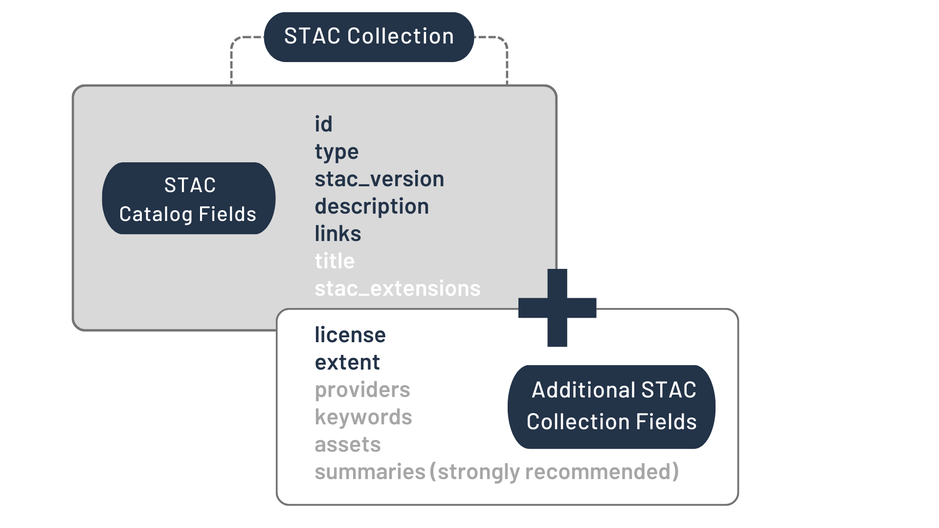
Figure by https://stacspec.org/ (license CC BY 4.0)
4.1.3. STAC Item
STAC Item is built upon the GeoJSON specification. GeoJSON is a format for encoding different geometric data structures such as points, lines and polygons. It is widely used by standard geospatial libraries such as Shapely.
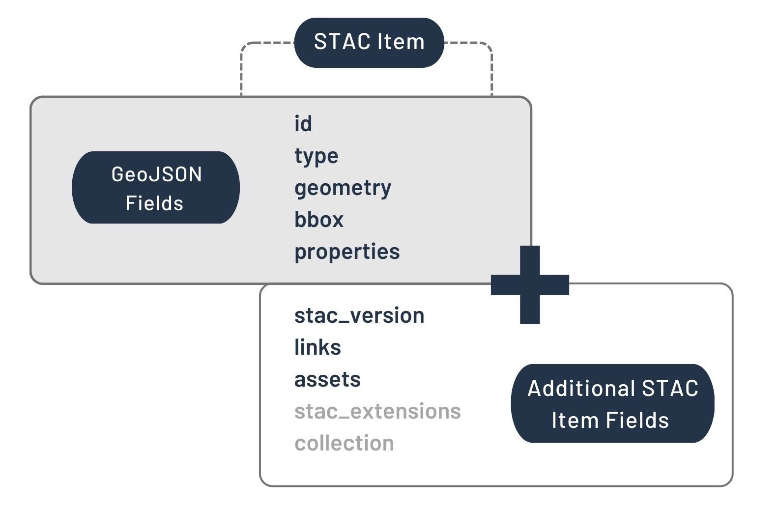
Figure by https://stacspec.org/ (license CC BY 4.0)
4.2. Opening CDOS’s STAC Catalog
4.2.1. CDOS API connection
Let’s start by opening a client object to the CDOS STAC catalog.
IMPORTANT: The URLs that we obtain from the STAC Catalog are not valid indefinitely. They expire after about 5 days. If you see an error in the notebook, it is likely because the URL that you obtained by running the first few cells has now expired. If that happens you should be able to just run the notebook again from the top to get a new URL. You can get longer-lasting URLs by registering an API key. More info here.
Most of the objects we will be using in this notebook include rich text formatting and some HTML. That means we can easily have a look at objects by using the display function of IPython.display or simply using the default output behavior of the last line of the cell in notebooks.
<Client id=MTD STAC API>
- type "Catalog"
- id "MTD STAC API"
- stac_version "1.1.0"
- description "Spatio Temporal Assets Catalog powered by 'Maison de la Teledetection' (aka MTD). It regroups scientific productions of UMR TETIS, UMR Espace-Dev, and external collaborators. See https://www.stac.teledetection.fr"
links[] 40 items
0
- rel "self"
- href "https://api.stac.teledetection.fr"
- type "application/json"
1
- rel "root"
- href "https://api.stac.teledetection.fr/"
- type "application/json"
- title "MTD STAC API"
2
- rel "data"
- href "https://api.stac.teledetection.fr/collections"
- type "application/json"
3
- rel "conformance"
- href "https://api.stac.teledetection.fr/conformance"
- type "application/json"
- title "STAC/OGC conformance classes implemented by this server"
4
- rel "search"
- href "https://api.stac.teledetection.fr/search"
- type "application/geo+json"
- title "STAC search"
- method "GET"
5
- rel "search"
- href "https://api.stac.teledetection.fr/search"
- type "application/geo+json"
- title "STAC search"
- method "POST"
6
- rel "http://www.opengis.net/def/rel/ogc/1.0/queryables"
- href "https://api.stac.teledetection.fr/queryables"
- type "application/schema+json"
- title "Queryables"
- method "GET"
7
- rel "child"
- href "https://api.stac.teledetection.fr/collections/sentinel2-l2a-sen2lasrc"
- type "application/json"
- title "Sentinel-2 Level 2A Sen2LaSRC"
8
- rel "child"
- href "https://api.stac.teledetection.fr/collections/corona-4b"
- type "application/json"
- title "Corona 4B"
9
- rel "child"
- href "https://api.stac.teledetection.fr/collections/becarun"
- type "application/json"
- title "Lidar BECARUN (COPC)"
10
- rel "child"
- href "https://api.stac.teledetection.fr/collections/spot-6-7-trees-footprint"
- type "application/json"
- title "Spot 6/7 trees footprint"
11
- rel "child"
- href "https://api.stac.teledetection.fr/collections/spot-6-7-footprints"
- type "application/json"
- title "Spot 6/7 6-classes footprints"
12
- rel "child"
- href "https://api.stac.teledetection.fr/collections/costarica-sentinel-2-l2-spectral-indices"
- type "application/json"
- title "costarica-sentinel-2-l2-spectral-indices"
13
- rel "child"
- href "https://api.stac.teledetection.fr/collections/costarica-sentinel-2-l3-seasonal-spectral-indices"
- type "application/json"
- title "costarica-sentinel-2-l3-seasonal-spectral-indices"
14
- rel "child"
- href "https://api.stac.teledetection.fr/collections/costarica-sentinel-2-l3-seasonal-spectral-indices-M"
- type "application/json"
- title "costarica-sentinel-2-l3-seasonal-spectral-indices-M"
15
- rel "child"
- href "https://api.stac.teledetection.fr/collections/costarica-sentinel-2-l4-seasonal-diversity-indices"
- type "application/json"
- title "costarica-sentinel-2-l4-seasonal-diversity-indices"
16
- rel "child"
- href "https://api.stac.teledetection.fr/collections/spot-6-7-drs"
- type "application/json"
- title "Spot-6/7 DINAMIS products"
17
- rel "child"
- href "https://api.stac.teledetection.fr/collections/geogedi"
- type "application/json"
- title "GeoGEDI L2A"
18
- rel "child"
- href "https://api.stac.teledetection.fr/collections/super-sentinel-2-l2a"
- type "application/json"
- title "Synthetic Sentinel-2 L2A (R, G, B, NIR) fused with Spot-6/7"
19
- rel "child"
- href "https://api.stac.teledetection.fr/collections/oso"
- type "application/json"
- title "France land cover map (OSO)"
20
- rel "child"
- href "https://api.stac.teledetection.fr/collections/spot-6-7-buildings-footprint"
- type "application/json"
- title "Spot 6/7 buildings footprint"
21
- rel "child"
- href "https://api.stac.teledetection.fr/collections/sentinel-derived-soil-moisture-oldprod"
- type "application/json"
- title "Sentinel-1/Sentinel-2 derived soil Moisture product at Plot scale (S2MP:v1)"
22
- rel "child"
- href "https://api.stac.teledetection.fr/collections/spot-6-7-solar-panels"
- type "application/json"
- title "Solar panels mapping from Spot-6/7 imagery"
23
- rel "child"
- href "https://api.stac.teledetection.fr/collections/forms-t"
- type "application/json"
- title "FORMS-T"
24
- rel "child"
- href "https://api.stac.teledetection.fr/collections/french-tiled-rpg"
- type "application/json"
- title "Registre Parcellaire Graphique français"
25
- rel "child"
- href "https://api.stac.teledetection.fr/collections/spot-6-7-solar-panels-v2"
- type "application/json"
- title "Solar panels mapping from Spot-6/7 imagery (v2)"
26
- rel "child"
- href "https://api.stac.teledetection.fr/collections/srtm-gl1-hgt"
- type "application/json"
- title "HGT SRTM 1arcsec"
27
- rel "child"
- href "https://api.stac.teledetection.fr/collections/lidarhd"
- type "application/json"
- title "Lidar HD point cloud (COPC)"
28
- rel "child"
- href "https://api.stac.teledetection.fr/collections/reconfort-chene"
- type "application/json"
- title "RECONFORT Chene"
29
- rel "child"
- href "https://api.stac.teledetection.fr/collections/sentinel2-l2a-theia-patches-stats"
- type "application/json"
- title "Sentinel-2 Level-2A-THEIA patches statistics over MGRS tiles"
30
- rel "child"
- href "https://api.stac.teledetection.fr/collections/s1-grd-sigma0-ortho-patches-stats"
- type "application/json"
- title "Sentinel 1 patches statistics over MGRS tiles"
31
- rel "child"
- href "https://api.stac.teledetection.fr/collections/fordead-fit"
- type "application/json"
- title "FORDEAD harmonic model"
32
- rel "child"
- href "https://api.stac.teledetection.fr/collections/s2mp-rpg-fr"
- type "application/json"
- title "GDC-MTD Sentinel Soil Moisture products (S2MP) over french agricultural plot"
33
- rel "child"
- href "https://api.stac.teledetection.fr/collections/s1-grd-sigma0-ortho"
- type "application/json"
- title "Sentinel-1 sigma0 ortho"
34
- rel "child"
- href "https://api.stac.teledetection.fr/collections/fordead-predict"
- type "application/json"
- title "FORDEAD predict"
35
- rel "child"
- href "https://api.stac.teledetection.fr/collections/sentinel2-l2a-theia"
- type "application/json"
- title "Sentinel-2 Level 2A"
36
- rel "child"
- href "https://api.stac.teledetection.fr/collections/sentinel2-l2a-sen2cor"
- type "application/json"
- title "Sentinel-2 Level 2A Sen2Cor"
37
- rel "child"
- href "https://api.stac.teledetection.fr/collections/sentinel-2-radiometric-indices"
- type "application/json"
- title "Sentinel-2 Level 2A radiometric indices"
38
- rel "service-desc"
- href "https://api.stac.teledetection.fr/api"
- type "application/vnd.oai.openapi+json;version=3.0"
- title "OpenAPI service description"
39
- rel "service-doc"
- href "https://api.stac.teledetection.fr/api.html"
- type "text/html"
- title "OpenAPI service documentation"
conformsTo[] 18 items
- 0 "http://www.opengis.net/spec/ogcapi-features-1/1.0/conf/core"
- 1 "https://api.stacspec.org/v1.0.0/ogcapi-features/extensions/transaction"
- 2 "http://www.opengis.net/spec/ogcapi-features-3/1.0/conf/features-filter"
- 3 "http://www.opengis.net/spec/ogcapi-features-3/1.0/conf/filter"
- 4 "https://api.stacspec.org/v1.0.0/item-search#query"
- 5 "http://www.opengis.net/spec/cql2/1.0/conf/cql2-text"
- 6 "https://api.stacspec.org/v1.0.0/item-search"
- 7 "https://api.stacspec.org/v1.0.0/item-search#fields"
- 8 "https://api.stacspec.org/v1.0.0/ogcapi-features"
- 9 "https://api.stacspec.org/v1.0.0/collections/extensions/transaction"
- 10 "http://www.opengis.net/spec/cql2/1.0/conf/basic-cql2"
- 11 "https://api.stacspec.org/v1.0.0/collections"
- 12 "https://api.stacspec.org/v1.0.0/core"
- 13 "http://www.opengis.net/spec/ogcapi-features-1/1.0/conf/oas30"
- 14 "https://api.stacspec.org/v1.0.0/item-search#sort"
- 15 "http://www.opengis.net/spec/ogcapi-features-1/1.0/conf/geojson"
- 16 "https://api.stacspec.org/v1.0.0-rc.2/item-search#filter"
- 17 "http://www.opengis.net/spec/cql2/1.0/conf/cql2-json"
- title "MTD STAC API"
Let’s have a look at the contents of the catalog object. This particular Catalog object we have created is the parent group of all the STAC objects that Planetary Computer provides.
As a reference here is a list of the fields defined in the STAC Catalog specification. | Element | Type | Description | | ————— | ————- | ———————————————————— | | type | string | REQUIRED. Set to Catalog if this Catalog only implements the Catalog spec. | | stac_version | string | REQUIRED. The STAC version the Catalog implements. | | stac_extensions | [string] | A list of extension identifiers the Catalog implements. | | id | string | REQUIRED. Identifier for the Catalog. | | title | string | A short descriptive one-line title for the Catalog. | | description | string | REQUIRED. Detailed multi-line description to fully explain the Catalog. CommonMark 0.29 syntax MAY be used for rich text representation. | | links | [Link Object] | REQUIRED. A list of references to other documents. |
We can see that the catalog object does contain most of the required fields for a Catalog object. However it does not include the stac_version field, so it is not technically a completely valid Catalog object.
4.2.2. List of collections
Now let’s look at the Collection objects that are in catalog.
collections = [
    (collection.id, collection.title) for collection in api.get_collections()
]
pd.set_option("display.max_rows", 150)

pd.DataFrame(collections, columns=["Collection ID", "Collection Title"])| Collection ID | Collection Title | |
|---|---|---|
| 0 | sentinel2-l2a-sen2lasrc | Sentinel-2 Level 2A Sen2LaSRC |
| 1 | corona-4b | Corona 4B |
| 2 | becarun | Lidar BECARUN (COPC) |
| 3 | spot-6-7-trees-footprint | Spot 6/7 trees footprint |
| 4 | spot-6-7-footprints | Spot 6/7 6-classes footprints |
| 5 | costarica-sentinel-2-l2-spectral-indices | costarica-sentinel-2-l2-spectral-indices |
| 6 | costarica-sentinel-2-l3-seasonal-spectral-indices | costarica-sentinel-2-l3-seasonal-spectral-indices |
| 7 | costarica-sentinel-2-l3-seasonal-spectral-indi... | costarica-sentinel-2-l3-seasonal-spectral-indi... |
| 8 | costarica-sentinel-2-l4-seasonal-diversity-ind... | costarica-sentinel-2-l4-seasonal-diversity-ind... |
| 9 | spot-6-7-drs | Spot-6/7 DINAMIS products |
| 10 | geogedi | GeoGEDI L2A |
| 11 | super-sentinel-2-l2a | Synthetic Sentinel-2 L2A (R, G, B, NIR) fused ... |
| 12 | oso | France land cover map (OSO) |
| 13 | spot-6-7-buildings-footprint | Spot 6/7 buildings footprint |
| 14 | sentinel-derived-soil-moisture-oldprod | Sentinel-1/Sentinel-2 derived soil Moisture pr... |
| 15 | spot-6-7-solar-panels | Solar panels mapping from Spot-6/7 imagery |
| 16 | forms-t | FORMS-T |
| 17 | french-tiled-rpg | Registre Parcellaire Graphique français |
| 18 | spot-6-7-solar-panels-v2 | Solar panels mapping from Spot-6/7 imagery (v2) |
| 19 | srtm-gl1-hgt | HGT SRTM 1arcsec |
| 20 | lidarhd | Lidar HD point cloud (COPC) |
| 21 | reconfort-chene | RECONFORT Chene |
| 22 | sentinel2-l2a-theia-patches-stats | Sentinel-2 Level-2A-THEIA patches statistics o... |
| 23 | s1-grd-sigma0-ortho-patches-stats | Sentinel 1 patches statistics over MGRS tiles |
| 24 | fordead-fit | FORDEAD harmonic model |
| 25 | s2mp-rpg-fr | GDC-MTD Sentinel Soil Moisture products (S2MP)... |
| 26 | s1-grd-sigma0-ortho | Sentinel-1 sigma0 ortho |
| 27 | fordead-predict | FORDEAD predict |
| 28 | sentinel2-l2a-theia | Sentinel-2 Level 2A |
| 29 | sentinel2-l2a-sen2cor | Sentinel-2 Level 2A Sen2Cor |
| 30 | sentinel-2-radiometric-indices | Sentinel-2 Level 2A radiometric indices |
4.2.3. Exploring a Sentinel-2 collection
In the table above we can clearly see how each collection (i.e. each row) of Planetary Computer’s catalog corresponds to a dataset with common properties. Let’s now look at a collection in particular:
# We use the collection id from the table above to obtain the collection object
collection_name = "sentinel2-l2a-theia"
catalog_s2 = api.get_collection(collection_name)
catalog_s2
<CollectionClient id=sentinel2-l2a-theia>
- type "Collection"
- id "sentinel2-l2a-theia"
- stac_version "1.1.0"
- description "Sentinel-2 Level 2A images produced by CNES/CESBIO"
links[] 5 items
0
- rel "items"
- href "https://api.stac.teledetection.fr/collections/sentinel2-l2a-theia/items"
- type "application/geo+json"
1
- rel "parent"
- href "https://api.stac.teledetection.fr/"
- type "application/json"
2
- rel "root"
- href "https://api.stac.teledetection.fr"
- type "application/json"
- title "MTD STAC API"
3
- rel "self"
- href "https://api.stac.teledetection.fr/collections/sentinel2-l2a-theia"
- type "application/json"
4
- rel "http://www.opengis.net/def/rel/ogc/1.0/queryables"
- href "https://api.stac.teledetection.fr/collections/sentinel2-l2a-theia/queryables"
- type "application/schema+json"
- title "Queryables"
stac_extensions[] 12 items
- 0 "https://forge.inrae.fr/teledec/stac-extensions/schemas/-/raw/main/theia/v1.1.0/schema.json?ref_type=heads"
- 1 "https://stac-extensions.github.io/eo/v1.1.0/schema.json"
- 2 "https://stac-extensions.github.io/projection/v1.1.0/schema.json"
- 3 "https://stac-extensions.github.io/processing/v1.2.0/schema.json"
- 4 "https://stac-extensions.github.io/mgrs/v1.0.0/schema.json"
- 5 "https://stac-extensions.github.io/raster/v1.1.0/schema.json"
- 6 "https://schemas.stacspec.org/v1.1.0/item-spec/json-schema/instrument.json"
- 7 "https://stac-extensions.github.io/sentinel-2/v1.0.0/schema.json"
- 8 "https://forge.inrae.fr/teledec/stac-extensions/schemas/-/raw/main/production/v1.1.0/schema.json"
- 9 "https://stac-extensions.github.io/sat/v1.0.0/schema.json"
- 10 "https://stac-extensions.github.io/product/v0.1.0/schema.json"
- 11 "https://stac-extensions.github.io/contacts/v0.1.1/schema.json"
contacts[] 2 items
0
- name "Rémi Cresson"
- organization "INRAE"
1
- name "Florian De Boissieu"
- organization "INRAE"
- title "Sentinel-2 Level 2A"
extent
spatial
bbox[] 1 items
0[] 4 items
- 0 -5.719358444214
- 1 41.456241607666
- 2 10.354447364807
- 3 51.451183319092
temporal
interval[] 1 items
0[] 2 items
- 0 "2015-07-04T10:18:58.537000Z"
- 1 "2025-09-22T11:28:19.760000Z"
- license "etalab-2.0"
assets
QL
- href "https://i.ibb.co/TKDJV0Z/sentinel-2-quicklook.png"
- type "image/png"
- description "true color image quicklook"
roles[] 1 items
- 0 "thumbnail"
By reading the description field we can see that this collection contains all of the data from Sentinel-2 processed to L2A (bottom-of-atmosphere), ranging from 2016 to the present. It is obvious that looking through all this data in the same way that we did for the collections themselves would not be practical.
The simplest way to search through a catalog is to use the search method on a catalog object. The important arguments for the search methods are the following: - collections: restricts the search to the collections which id were provided - restricting spatial extent using either: - bbox : simple bounding box given as [min(longitude), min(latitude), max(longitude), max(latitude)] - intersects : GeoJSON object, or an object implementing a __geo_interface__ property (supported by libraries such as Shapely, ARcPy, PySAL, geojson) - datetime : using a datetime.datetime object or a string. For a time range you can use 'yyyy-mm-dd/yyyy-mm-dd' (beginning/end), or even '2017' as a shortcut for '2017-01-01/2017-12-31', and 2017-06 for the whole month of June 2017 - query : a list of JSON of query parameters. This allows to search for specific properties of items (such as cloud cover), and will be used in a later notebook
Note: Finding GPS coordinates can be as simple as going to google.com/maps and right clicking a point on the map. However, be careful that although standards dictate that coordinates should be given with latitude first and longitude second, some tools and libraries use longitude first and latitude second, often as a similarity to \((x,y)\) coordinates on a plane.
For now, let’s reuse the extent GeoJSON Polygon we created earlier.
{'type': 'Polygon',
 'coordinates': [[[4.118824575734205, 43.48641456618909],
   [4.118824575734205, 43.71739887308995],
   [3.875107329166124, 43.71739887308995],
   [3.875107329166124, 43.48641456618909],
   [4.118824575734205, 43.48641456618909]]]}
The bbox parameter expects a Python list formatted as follows:
[xmin, ymin, xmax, ymax]So we have to modify area_of_interest in order to keep the right coordinates.
# Here is the equivalent bbox object to the polygon above
# using a numpy array for convenient axis operations
coords = np.array([area_of_interest["coordinates"]][0][0])
bbox = [*coords.min(0), *coords.max(0)]
bbox
[3.875107329166124, 43.48641456618909, 4.118824575734205, 43.71739887308995]Let’s use the following datetime format:
"start_date<yyyy-mm-dd>/end_date<yyyy-mm-dd>"Now, we can search the Sentinel-2 images (i.e. STAC Items) that match our criteria. Here we present the two ways to pass the spatial query (bbox and intersects).
# the id for a collection can be found in the table we created earlier
collections = [collection_name]

# As expected the GeoJSON object and
# bounding box methods give the same results
search = api.search(collections=collections, datetime=time_range, bbox=bbox)
items = search.get_all_items()
print(f"{len(items)} items found with the `bbox` parameter")

search = api.search(
    collections=collections,
    datetime=time_range,
    intersects=area_of_interest,
)
items = search.get_all_items()
print(f"{len(items)} items found with the `intersects` parameter")
/opt/conda/envs/tmp/lib/python3.11/site-packages/pystac_client/item_search.py:940: FutureWarning: get_all_items() is deprecated, use item_collection() instead.
warnings.warn(5 items found with the `bbox` parameter
5 items found with the `intersects` parameterThe result of a search is an ItemCollection, which is similar to the objects we’ve seen previously. Thus we can look through it just the same with display or Jupyter’s cell magic. We can then check that the results are from the right dataset (Sentinel-2 L2A), the right date ranges, and the geometry we specified falls within the specified bbox of each item.
<pystac.item_collection.ItemCollection object at 0x7f946860e9d0>
- type "FeatureCollection"
features[] 5 items
0
- type "Feature"
- stac_version "1.1.0"
stac_extensions[] 11 items
- 0 "https://forge.inrae.fr/teledec/stac-extensions/schemas/-/raw/main/theia/v1.1.0/schema.json?ref_type=heads"
- 1 "https://stac-extensions.github.io/mgrs/v1.0.0/schema.json"
- 2 "https://stac-extensions.github.io/eo/v1.1.0/schema.json"
- 3 "https://stac-extensions.github.io/sat/v1.0.0/schema.json"
- 4 "https://stac-extensions.github.io/product/v0.1.0/schema.json"
- 5 "https://stac-extensions.github.io/processing/v1.2.0/schema.json"
- 6 "https://schemas.stacspec.org/v1.1.0/item-spec/json-schema/instrument.json"
- 7 "https://stac-extensions.github.io/sentinel-2/v1.0.0/schema.json"
- 8 "https://forge.inrae.fr/teledec/stac-extensions/schemas/-/raw/main/production/v1.1.0/schema.json"
- 9 "https://stac-extensions.github.io/raster/v1.1.0/schema.json"
- 10 "https://stac-extensions.github.io/projection/v2.0.0/schema.json"
- id "SENTINEL2A_20201230-103858-586_L2A_T31TEJ_C"
geometry
- type "Polygon"
coordinates[] 1 items
0[] 5 items
0[] 2 items
- 0 2.999749422073
- 1 44.25341796875
1[] 2 items
- 0 4.374939918518
- 1 44.245143890381
2[] 2 items
- 0 4.352494239807
- 1 43.25679397583
3[] 2 items
- 0 2.999753475189
- 1 43.264789581299
4[] 2 items
- 0 2.999749422073
- 1 44.25341796875
bbox[] 4 items
- 0 2.999749422073
- 1 43.25679397583
- 2 4.374939918518
- 3 44.25341796875
properties
- created "2025-07-04T15:23:58.125282Z"
- updated "2025-09-05T01:30:21.004803Z"
- datetime "2020-12-30T10:38:58.586000Z"
- platform "S2A"
instruments[] 1 items
- 0 "MSI"
- product:type "REFLECTANCE"
- s2:mgrs_tile "31TEJ"
- constellation "sentinel-2"
- eo:snow_cover 0.0
- mgrs:utm_zone 31
- eo:cloud_cover 4.0
- mgrs:grid_square "EJ"
- processing:level "L2A"
- theia:archive_url "https://s3.datalake.cnes.fr/sentinel2-l2a-sprid/T31TEJ/2020/12/30/SENTINEL2A_20201230-103858-586_L2A_T31TEJ_C/20250509-092215441/SENTINEL2A_20201230-103858-586_L2A_T31TEJ_C_V4-0.zip"
- mgrs:latitude_band "T"
- processing:version "4-0"
production:origins
src
ids[] 1 items
- 0 "SENTINEL2A_20201230-103858-586_L2A_T31TEJ_C"
- endpoint "https://geodes-portal.cnes.fr/api/stac"
- collection "MUSCATE_SENTINEL2_SENTINEL2_L2A"
- production:version "0.6.1"
- sat:absolute_orbit 28849
- sat:relative_orbit 108
- processing:facility "THEIA-MTP"
- theia:archive_checksum "ac769446020815123a8a3044cf3d7212"
- theia:archive_identifier "URN:FEATURE:DATA:gdh:79659aeb-95b5-325e-a638-ad4bc2bcd399:V1"
links[] 4 items
0
- rel "collection"
- href "https://api.stac.teledetection.fr/collections/sentinel2-l2a-theia"
- type "application/json"
1
- rel "parent"
- href "https://api.stac.teledetection.fr/collections/sentinel2-l2a-theia"
- type "application/json"
2
- rel "root"
- href "https://api.stac.teledetection.fr"
- type "application/json"
- title "MTD STAC API"
3
- rel "self"
- href "https://api.stac.teledetection.fr/collections/sentinel2-l2a-theia/items/SENTINEL2A_20201230-103858-586_L2A_T31TEJ_C"
- type "application/geo+json"
assets
MD
- href "https://s3-data.meso.umontpellier.fr/s2-theia/sentinel2-l2a-theia/SENTINEL2A_20201230-103858-586_L2A_T31TEJ_C/SENTINEL2A_20201230-103858-586_L2A_T31TEJ_C_V4-0_MTD_ALL.xml?X-Amz-Algorithm=AWS4-HMAC-SHA256&X-Amz-Credential=7Q29ZHPX0CS1HYBBJ5RZ%2F20250926%2Fus-east-1%2Fs3%2Faws4_request&X-Amz-Date=20250926T141444Z&X-Amz-Expires=28800&X-Amz-SignedHeaders=host&X-Amz-Signature=078b11905ce79bdf50fcde13ae63d2042ddc9b32aef4f15933fd58b63a4184d2"
- type "application/xml"
- title "metadata"
- description "metadata"
- production:definition_sha "de96a3296d128088280ab65645fb646131b699a9"
- production:implementation_sha "5c87e3a93a7c86929db38e7c2ea4d6a76479fd66"
roles[] 1 items
- 0 "metadata"
QL
- href "https://s3-data.meso.umontpellier.fr/s2-theia/sentinel2-l2a-theia/SENTINEL2A_20201230-103858-586_L2A_T31TEJ_C/SENTINEL2A_20201230-103858-586_L2A_T31TEJ_C_V4-0_QKL_ALL.jpg?X-Amz-Algorithm=AWS4-HMAC-SHA256&X-Amz-Credential=7Q29ZHPX0CS1HYBBJ5RZ%2F20250926%2Fus-east-1%2Fs3%2Faws4_request&X-Amz-Date=20250926T141444Z&X-Amz-Expires=28800&X-Amz-SignedHeaders=host&X-Amz-Signature=a975cc6e47f44f17fc7935e83dba490230a5f792f0dd263f2f4a989d4216db5c"
- type "text/plain"
- title "quicklook"
- description "true color image quicklook"
- production:definition_sha "de96a3296d128088280ab65645fb646131b699a9"
- production:implementation_sha "5c87e3a93a7c86929db38e7c2ea4d6a76479fd66"
roles[] 2 items
- 0 "thumbnail"
- 1 "overview"
B02
- href "https://s3-data.meso.umontpellier.fr/s2-theia/sentinel2-l2a-theia/SENTINEL2A_20201230-103858-586_L2A_T31TEJ_C/SENTINEL2A_20201230-103858-586_L2A_T31TEJ_C_V4-0_FRE_B2.tif?X-Amz-Algorithm=AWS4-HMAC-SHA256&X-Amz-Credential=7Q29ZHPX0CS1HYBBJ5RZ%2F20250926%2Fus-east-1%2Fs3%2Faws4_request&X-Amz-Date=20250926T141444Z&X-Amz-Expires=28800&X-Amz-SignedHeaders=host&X-Amz-Signature=80c254238d27c9016015ea105a60ad74d679a3e1f7797fffe4eb7ab5debc84d3"
- type "image/tiff; application=geotiff; profile=cloud-optimized"
- title "spectral band 2"
- description "spectral band 2 (blue)"
eo:bands[] 1 items
0
- name "B02"
- common_name "blue"
- description "Band 2 - Blue"
- center_wavelength 0.4927
- full_width_half_max 0.065
proj:bbox[] 4 items
- 0 499980.0
- 1 4790220.0
- 2 609780.0
- 3 4900020.0
proj:shape[] 2 items
- 0 10980
- 1 10980
raster:bands[] 1 items
0
- scale 1.0
- nodata -10000.0
- offset 0.0
- sampling "area"
- data_type "int16"
statistics
- mean 478.3119382276691
- stddev 673.4687920823638
- maximum 11547.0
- minimum 0.0
proj:geometry
- type "Polygon"
coordinates[] 1 items
0[] 5 items
0[] 2 items
- 0 499980.0
- 1 4790220.0
1[] 2 items
- 0 609780.0
- 1 4790220.0
2[] 2 items
- 0 609780.0
- 1 4900020.0
3[] 2 items
- 0 499980.0
- 1 4900020.0
4[] 2 items
- 0 499980.0
- 1 4790220.0
proj:transform[] 9 items
- 0 10.0
- 1 0.0
- 2 499980.0
- 3 0.0
- 4 -10.0
- 5 4900020.0
- 6 0.0
- 7 0.0
- 8 1.0
- production:definition_sha "de96a3296d128088280ab65645fb646131b699a9"
- production:implementation_sha "5c87e3a93a7c86929db38e7c2ea4d6a76479fd66"
- proj:code "EPSG:32631"
roles[] 3 items
- 0 "reflectance"
- 1 "gsd:10m"
- 2 "data"
B03
- href "https://s3-data.meso.umontpellier.fr/s2-theia/sentinel2-l2a-theia/SENTINEL2A_20201230-103858-586_L2A_T31TEJ_C/SENTINEL2A_20201230-103858-586_L2A_T31TEJ_C_V4-0_FRE_B3.tif?X-Amz-Algorithm=AWS4-HMAC-SHA256&X-Amz-Credential=7Q29ZHPX0CS1HYBBJ5RZ%2F20250926%2Fus-east-1%2Fs3%2Faws4_request&X-Amz-Date=20250926T141444Z&X-Amz-Expires=28800&X-Amz-SignedHeaders=host&X-Amz-Signature=40e3469b8e71123756953e4bfac437f31e0e301ef5edd24393917840976c6a95"
- type "image/tiff; application=geotiff; profile=cloud-optimized"
- title "spectral band 3"
- description "spectral band 3 (green)"
eo:bands[] 1 items
0
- name "B03"
- common_name "green"
- description "Band 3 - Green"
- center_wavelength 0.5598
- full_width_half_max 0.035
proj:bbox[] 4 items
- 0 499980.0
- 1 4790220.0
- 2 609780.0
- 3 4900020.0
proj:shape[] 2 items
- 0 10980
- 1 10980
raster:bands[] 1 items
0
- scale 1.0
- nodata -10000.0
- offset 0.0
- sampling "area"
- data_type "int16"
statistics
- mean 589.1224588284946
- stddev 722.05369116963
- maximum 12221.0
- minimum 0.0
proj:geometry
- type "Polygon"
coordinates[] 1 items
0[] 5 items
0[] 2 items
- 0 499980.0
- 1 4790220.0
1[] 2 items
- 0 609780.0
- 1 4790220.0
2[] 2 items
- 0 609780.0
- 1 4900020.0
3[] 2 items
- 0 499980.0
- 1 4900020.0
4[] 2 items
- 0 499980.0
- 1 4790220.0
proj:transform[] 9 items
- 0 10.0
- 1 0.0
- 2 499980.0
- 3 0.0
- 4 -10.0
- 5 4900020.0
- 6 0.0
- 7 0.0
- 8 1.0
- production:definition_sha "de96a3296d128088280ab65645fb646131b699a9"
- production:implementation_sha "5c87e3a93a7c86929db38e7c2ea4d6a76479fd66"
- proj:code "EPSG:32631"
roles[] 3 items
- 0 "reflectance"
- 1 "gsd:10m"
- 2 "data"
B04
- href "https://s3-data.meso.umontpellier.fr/s2-theia/sentinel2-l2a-theia/SENTINEL2A_20201230-103858-586_L2A_T31TEJ_C/SENTINEL2A_20201230-103858-586_L2A_T31TEJ_C_V4-0_FRE_B4.tif?X-Amz-Algorithm=AWS4-HMAC-SHA256&X-Amz-Credential=7Q29ZHPX0CS1HYBBJ5RZ%2F20250926%2Fus-east-1%2Fs3%2Faws4_request&X-Amz-Date=20250926T141444Z&X-Amz-Expires=28800&X-Amz-SignedHeaders=host&X-Amz-Signature=0ef6a3ef37429a0cf0026cda525106d93dcbf72b351f1f23705a69927aec0575"
- type "image/tiff; application=geotiff; profile=cloud-optimized"
- title "spectral band 4"
- description "spectral band 4 (red)"
eo:bands[] 1 items
0
- name "B04"
- common_name "red"
- description "Band 4 - Red"
- center_wavelength 0.6646
- full_width_half_max 0.03
proj:bbox[] 4 items
- 0 499980.0
- 1 4790220.0
- 2 609780.0
- 3 4900020.0
proj:shape[] 2 items
- 0 10980
- 1 10980
raster:bands[] 1 items
0
- scale 1.0
- nodata -10000.0
- offset 0.0
- sampling "area"
- data_type "int16"
statistics
- mean 547.359956566329
- stddev 811.246622434711
- maximum 12642.0
- minimum 0.0
proj:geometry
- type "Polygon"
coordinates[] 1 items
0[] 5 items
0[] 2 items
- 0 499980.0
- 1 4790220.0
1[] 2 items
- 0 609780.0
- 1 4790220.0
2[] 2 items
- 0 609780.0
- 1 4900020.0
3[] 2 items
- 0 499980.0
- 1 4900020.0
4[] 2 items
- 0 499980.0
- 1 4790220.0
proj:transform[] 9 items
- 0 10.0
- 1 0.0
- 2 499980.0
- 3 0.0
- 4 -10.0
- 5 4900020.0
- 6 0.0
- 7 0.0
- 8 1.0
- production:definition_sha "de96a3296d128088280ab65645fb646131b699a9"
- production:implementation_sha "5c87e3a93a7c86929db38e7c2ea4d6a76479fd66"
- proj:code "EPSG:32631"
roles[] 3 items
- 0 "reflectance"
- 1 "gsd:10m"
- 2 "data"
B05
- href "https://s3-data.meso.umontpellier.fr/s2-theia/sentinel2-l2a-theia/SENTINEL2A_20201230-103858-586_L2A_T31TEJ_C/SENTINEL2A_20201230-103858-586_L2A_T31TEJ_C_V4-0_FRE_B5.tif?X-Amz-Algorithm=AWS4-HMAC-SHA256&X-Amz-Credential=7Q29ZHPX0CS1HYBBJ5RZ%2F20250926%2Fus-east-1%2Fs3%2Faws4_request&X-Amz-Date=20250926T141444Z&X-Amz-Expires=28800&X-Amz-SignedHeaders=host&X-Amz-Signature=f7f815198cca73996a8a26c6c76283a40b2aa33f03d58359c02ab4f957259e8a"
- type "image/tiff; application=geotiff; profile=cloud-optimized"
- title "spectral band 5"
- description "spectral band 5 (rededge)"
eo:bands[] 1 items
0
- name "B05"
- common_name "rededge"
- description "Band 5 - Vegetation red edge 1"
- center_wavelength 0.7041
- full_width_half_max 0.014
proj:bbox[] 4 items
- 0 499980.0
- 1 4790220.0
- 2 609780.0
- 3 4900020.0
proj:shape[] 2 items
- 0 5490
- 1 5490
raster:bands[] 1 items
0
- scale 1.0
- nodata -10000.0
- offset 0.0
- sampling "area"
- data_type "int16"
statistics
- mean 737.5710924775207
- stddev 885.9785337495666
- maximum 12435.0
- minimum 0.0
proj:geometry
- type "Polygon"
coordinates[] 1 items
0[] 5 items
0[] 2 items
- 0 499980.0
- 1 4790220.0
1[] 2 items
- 0 609780.0
- 1 4790220.0
2[] 2 items
- 0 609780.0
- 1 4900020.0
3[] 2 items
- 0 499980.0
- 1 4900020.0
4[] 2 items
- 0 499980.0
- 1 4790220.0
proj:transform[] 9 items
- 0 20.0
- 1 0.0
- 2 499980.0
- 3 0.0
- 4 -20.0
- 5 4900020.0
- 6 0.0
- 7 0.0
- 8 1.0
- production:definition_sha "de96a3296d128088280ab65645fb646131b699a9"
- production:implementation_sha "5c87e3a93a7c86929db38e7c2ea4d6a76479fd66"
- proj:code "EPSG:32631"
roles[] 3 items
- 0 "reflectance"
- 1 "gsd:20m"
- 2 "data"
B06
- href "https://s3-data.meso.umontpellier.fr/s2-theia/sentinel2-l2a-theia/SENTINEL2A_20201230-103858-586_L2A_T31TEJ_C/SENTINEL2A_20201230-103858-586_L2A_T31TEJ_C_V4-0_FRE_B6.tif?X-Amz-Algorithm=AWS4-HMAC-SHA256&X-Amz-Credential=7Q29ZHPX0CS1HYBBJ5RZ%2F20250926%2Fus-east-1%2Fs3%2Faws4_request&X-Amz-Date=20250926T141444Z&X-Amz-Expires=28800&X-Amz-SignedHeaders=host&X-Amz-Signature=e0c5ae72f17e358239869351b8ad3c18b101494a443e2dca498f3d6e1576ed4a"
- type "image/tiff; application=geotiff; profile=cloud-optimized"
- title "spectral band 6"
- description "spectral band 6 (rededge)"
eo:bands[] 1 items
0
- name "B06"
- common_name "rededge"
- description "Band 6 - Vegetation red edge 2"
- center_wavelength 0.7405
- full_width_half_max 0.014
proj:bbox[] 4 items
- 0 499980.0
- 1 4790220.0
- 2 609780.0
- 3 4900020.0
proj:shape[] 2 items
- 0 5490
- 1 5490
raster:bands[] 1 items
0
- scale 1.0
- nodata -10000.0
- offset 0.0
- sampling "area"
- data_type "int16"
statistics
- mean 1111.8083489171834
- stddev 1148.3445748555903
- maximum 12277.0
- minimum 0.0
proj:geometry
- type "Polygon"
coordinates[] 1 items
0[] 5 items
0[] 2 items
- 0 499980.0
- 1 4790220.0
1[] 2 items
- 0 609780.0
- 1 4790220.0
2[] 2 items
- 0 609780.0
- 1 4900020.0
3[] 2 items
- 0 499980.0
- 1 4900020.0
4[] 2 items
- 0 499980.0
- 1 4790220.0
proj:transform[] 9 items
- 0 20.0
- 1 0.0
- 2 499980.0
- 3 0.0
- 4 -20.0
- 5 4900020.0
- 6 0.0
- 7 0.0
- 8 1.0
- production:definition_sha "de96a3296d128088280ab65645fb646131b699a9"
- production:implementation_sha "5c87e3a93a7c86929db38e7c2ea4d6a76479fd66"
- proj:code "EPSG:32631"
roles[] 3 items
- 0 "reflectance"
- 1 "gsd:20m"
- 2 "data"
B07
- href "https://s3-data.meso.umontpellier.fr/s2-theia/sentinel2-l2a-theia/SENTINEL2A_20201230-103858-586_L2A_T31TEJ_C/SENTINEL2A_20201230-103858-586_L2A_T31TEJ_C_V4-0_FRE_B7.tif?X-Amz-Algorithm=AWS4-HMAC-SHA256&X-Amz-Credential=7Q29ZHPX0CS1HYBBJ5RZ%2F20250926%2Fus-east-1%2Fs3%2Faws4_request&X-Amz-Date=20250926T141444Z&X-Amz-Expires=28800&X-Amz-SignedHeaders=host&X-Amz-Signature=e9a70d6ecffdff602b0af693b48a9c5b4c1b38093bd69e6451a18242e6364393"
- type "image/tiff; application=geotiff; profile=cloud-optimized"
- title "spectral band 7"
- description "spectral band 7 (rededge)"
eo:bands[] 1 items
0
- name "B07"
- common_name "rededge"
- description "Band 7 - Vegetation red edge 3"
- center_wavelength 0.7828
- full_width_half_max 0.019
proj:bbox[] 4 items
- 0 499980.0
- 1 4790220.0
- 2 609780.0
- 3 4900020.0
proj:shape[] 2 items
- 0 5490
- 1 5490
raster:bands[] 1 items
0
- scale 1.0
- nodata -10000.0
- offset 0.0
- sampling "area"
- data_type "int16"
statistics
- mean 1229.7664233576654
- stddev 1234.3528770698751
- maximum 12227.0
- minimum 0.0
proj:geometry
- type "Polygon"
coordinates[] 1 items
0[] 5 items
0[] 2 items
- 0 499980.0
- 1 4790220.0
1[] 2 items
- 0 609780.0
- 1 4790220.0
2[] 2 items
- 0 609780.0
- 1 4900020.0
3[] 2 items
- 0 499980.0
- 1 4900020.0
4[] 2 items
- 0 499980.0
- 1 4790220.0
proj:transform[] 9 items
- 0 20.0
- 1 0.0
- 2 499980.0
- 3 0.0
- 4 -20.0
- 5 4900020.0
- 6 0.0
- 7 0.0
- 8 1.0
- production:definition_sha "de96a3296d128088280ab65645fb646131b699a9"
- production:implementation_sha "5c87e3a93a7c86929db38e7c2ea4d6a76479fd66"
- proj:code "EPSG:32631"
roles[] 3 items
- 0 "reflectance"
- 1 "gsd:20m"
- 2 "data"
B08
- href "https://s3-data.meso.umontpellier.fr/s2-theia/sentinel2-l2a-theia/SENTINEL2A_20201230-103858-586_L2A_T31TEJ_C/SENTINEL2A_20201230-103858-586_L2A_T31TEJ_C_V4-0_FRE_B8.tif?X-Amz-Algorithm=AWS4-HMAC-SHA256&X-Amz-Credential=7Q29ZHPX0CS1HYBBJ5RZ%2F20250926%2Fus-east-1%2Fs3%2Faws4_request&X-Amz-Date=20250926T141444Z&X-Amz-Expires=28800&X-Amz-SignedHeaders=host&X-Amz-Signature=0b20c2fa77ef0311c242ce1eba3d7678cf073cd6687557dea3ce61e87e7f7c84"
- type "image/tiff; application=geotiff; profile=cloud-optimized"
- title "spectral band 8"
- description "spectral band 8 (nir)"
eo:bands[] 1 items
0
- name "B08"
- common_name "nir"
- description "Band 8 - NIR"
- center_wavelength 0.8328
- full_width_half_max 0.105
proj:bbox[] 4 items
- 0 499980.0
- 1 4790220.0
- 2 609780.0
- 3 4900020.0
proj:shape[] 2 items
- 0 10980
- 1 10980
raster:bands[] 1 items
0
- scale 1.0
- nodata -10000.0
- offset 0.0
- sampling "area"
- data_type "int16"
statistics
- mean 1256.512939615138
- stddev 1268.3852190768578
- maximum 12126.0
- minimum 0.0
proj:geometry
- type "Polygon"
coordinates[] 1 items
0[] 5 items
0[] 2 items
- 0 499980.0
- 1 4790220.0
1[] 2 items
- 0 609780.0
- 1 4790220.0
2[] 2 items
- 0 609780.0
- 1 4900020.0
3[] 2 items
- 0 499980.0
- 1 4900020.0
4[] 2 items
- 0 499980.0
- 1 4790220.0
proj:transform[] 9 items
- 0 10.0
- 1 0.0
- 2 499980.0
- 3 0.0
- 4 -10.0
- 5 4900020.0
- 6 0.0
- 7 0.0
- 8 1.0
- production:definition_sha "de96a3296d128088280ab65645fb646131b699a9"
- production:implementation_sha "5c87e3a93a7c86929db38e7c2ea4d6a76479fd66"
- proj:code "EPSG:32631"
roles[] 3 items
- 0 "reflectance"
- 1 "gsd:10m"
- 2 "data"
B11
- href "https://s3-data.meso.umontpellier.fr/s2-theia/sentinel2-l2a-theia/SENTINEL2A_20201230-103858-586_L2A_T31TEJ_C/SENTINEL2A_20201230-103858-586_L2A_T31TEJ_C_V4-0_FRE_B11.tif?X-Amz-Algorithm=AWS4-HMAC-SHA256&X-Amz-Credential=7Q29ZHPX0CS1HYBBJ5RZ%2F20250926%2Fus-east-1%2Fs3%2Faws4_request&X-Amz-Date=20250926T141444Z&X-Amz-Expires=28800&X-Amz-SignedHeaders=host&X-Amz-Signature=65175643cc7854b1ccfcf075228c4a4f72f34442a313a3ee8055e0888a98889f"
- type "image/tiff; application=geotiff; profile=cloud-optimized"
- title "spectral band 11"
- description "spectral band 11 (swir16)"
eo:bands[] 1 items
0
- name "B11"
- common_name "swir16"
- description "Band 11 - SWIR (1.6)"
- center_wavelength 1.6137
- full_width_half_max 0.09
proj:bbox[] 4 items
- 0 499980.0
- 1 4790220.0
- 2 609780.0
- 3 4900020.0
proj:shape[] 2 items
- 0 5490
- 1 5490
raster:bands[] 1 items
0
- scale 1.0
- nodata -10000.0
- offset 0.0
- sampling "area"
- data_type "int16"
statistics
- mean 1107.5526934909672
- stddev 1174.5371190140077
- maximum 10079.0
- minimum 0.0
proj:geometry
- type "Polygon"
coordinates[] 1 items
0[] 5 items
0[] 2 items
- 0 499980.0
- 1 4790220.0
1[] 2 items
- 0 609780.0
- 1 4790220.0
2[] 2 items
- 0 609780.0
- 1 4900020.0
3[] 2 items
- 0 499980.0
- 1 4900020.0
4[] 2 items
- 0 499980.0
- 1 4790220.0
proj:transform[] 9 items
- 0 20.0
- 1 0.0
- 2 499980.0
- 3 0.0
- 4 -20.0
- 5 4900020.0
- 6 0.0
- 7 0.0
- 8 1.0
- production:definition_sha "de96a3296d128088280ab65645fb646131b699a9"
- production:implementation_sha "5c87e3a93a7c86929db38e7c2ea4d6a76479fd66"
- proj:code "EPSG:32631"
roles[] 3 items
- 0 "reflectance"
- 1 "gsd:20m"
- 2 "data"
B12
- href "https://s3-data.meso.umontpellier.fr/s2-theia/sentinel2-l2a-theia/SENTINEL2A_20201230-103858-586_L2A_T31TEJ_C/SENTINEL2A_20201230-103858-586_L2A_T31TEJ_C_V4-0_FRE_B12.tif?X-Amz-Algorithm=AWS4-HMAC-SHA256&X-Amz-Credential=7Q29ZHPX0CS1HYBBJ5RZ%2F20250926%2Fus-east-1%2Fs3%2Faws4_request&X-Amz-Date=20250926T141444Z&X-Amz-Expires=28800&X-Amz-SignedHeaders=host&X-Amz-Signature=1ca5541c5797b7d41b4c3f4266d0d34fd8f38aede57ac993da778d60c4300679"
- type "image/tiff; application=geotiff; profile=cloud-optimized"
- title "spectral band 12"
- description "spectral band 12 (swir22)"
eo:bands[] 1 items
0
- name "B12"
- common_name "swir22"
- description "Band 12 - SWIR (2.2)"
- center_wavelength 2.2024
- full_width_half_max 0.174
proj:bbox[] 4 items
- 0 499980.0
- 1 4790220.0
- 2 609780.0
- 3 4900020.0
proj:shape[] 2 items
- 0 5490
- 1 5490
raster:bands[] 1 items
0
- scale 1.0
- nodata -10000.0
- offset 0.0
- sampling "area"
- data_type "int16"
statistics
- mean 727.3494600953169
- stddev 860.1943037050075
- maximum 8173.0
- minimum 0.0
proj:geometry
- type "Polygon"
coordinates[] 1 items
0[] 5 items
0[] 2 items
- 0 499980.0
- 1 4790220.0
1[] 2 items
- 0 609780.0
- 1 4790220.0
2[] 2 items
- 0 609780.0
- 1 4900020.0
3[] 2 items
- 0 499980.0
- 1 4900020.0
4[] 2 items
- 0 499980.0
- 1 4790220.0
proj:transform[] 9 items
- 0 20.0
- 1 0.0
- 2 499980.0
- 3 0.0
- 4 -20.0
- 5 4900020.0
- 6 0.0
- 7 0.0
- 8 1.0
- production:definition_sha "de96a3296d128088280ab65645fb646131b699a9"
- production:implementation_sha "5c87e3a93a7c86929db38e7c2ea4d6a76479fd66"
- proj:code "EPSG:32631"
roles[] 3 items
- 0 "reflectance"
- 1 "gsd:20m"
- 2 "data"
B8A
- href "https://s3-data.meso.umontpellier.fr/s2-theia/sentinel2-l2a-theia/SENTINEL2A_20201230-103858-586_L2A_T31TEJ_C/SENTINEL2A_20201230-103858-586_L2A_T31TEJ_C_V4-0_FRE_B8A.tif?X-Amz-Algorithm=AWS4-HMAC-SHA256&X-Amz-Credential=7Q29ZHPX0CS1HYBBJ5RZ%2F20250926%2Fus-east-1%2Fs3%2Faws4_request&X-Amz-Date=20250926T141444Z&X-Amz-Expires=28800&X-Amz-SignedHeaders=host&X-Amz-Signature=84a6e3c21a7df8b32d449a86ffaefb4de49cf03d6ae2d877d525a32c227a931e"
- type "image/tiff; application=geotiff; profile=cloud-optimized"
- title "spectral band 8a"
- description "spectral band 8a (rededge)"
eo:bands[] 1 items
0
- name "B8A"
- common_name "rededge"
- description "Band 8A - Vegetation red edge 4"
- center_wavelength 0.8647
- full_width_half_max 0.021
proj:bbox[] 4 items
- 0 499980.0
- 1 4790220.0
- 2 609780.0
- 3 4900020.0
proj:shape[] 2 items
- 0 5490
- 1 5490
raster:bands[] 1 items
0
- scale 1.0
- nodata -10000.0
- offset 0.0
- sampling "area"
- data_type "int16"
statistics
- mean 1336.3586897508671
- stddev 1329.7153219313348
- maximum 12273.0
- minimum 0.0
proj:geometry
- type "Polygon"
coordinates[] 1 items
0[] 5 items
0[] 2 items
- 0 499980.0
- 1 4790220.0
1[] 2 items
- 0 609780.0
- 1 4790220.0
2[] 2 items
- 0 609780.0
- 1 4900020.0
3[] 2 items
- 0 499980.0
- 1 4900020.0
4[] 2 items
- 0 499980.0
- 1 4790220.0
proj:transform[] 9 items
- 0 20.0
- 1 0.0
- 2 499980.0
- 3 0.0
- 4 -20.0
- 5 4900020.0
- 6 0.0
- 7 0.0
- 8 1.0
- production:definition_sha "de96a3296d128088280ab65645fb646131b699a9"
- production:implementation_sha "5c87e3a93a7c86929db38e7c2ea4d6a76479fd66"
- proj:code "EPSG:32631"
roles[] 3 items
- 0 "reflectance"
- 1 "gsd:20m"
- 2 "data"
ATB_R1
- href "https://s3-data.meso.umontpellier.fr/s2-theia/sentinel2-l2a-theia/SENTINEL2A_20201230-103858-586_L2A_T31TEJ_C/SENTINEL2A_20201230-103858-586_L2A_T31TEJ_C_V4-0_ATB_R1.tif?X-Amz-Algorithm=AWS4-HMAC-SHA256&X-Amz-Credential=7Q29ZHPX0CS1HYBBJ5RZ%2F20250926%2Fus-east-1%2Fs3%2Faws4_request&X-Amz-Date=20250926T141444Z&X-Amz-Expires=28800&X-Amz-SignedHeaders=host&X-Amz-Signature=834d1fafaebb723d27418ef9feaa6459b056ecd72f9ded957b8dab4166245459"
- type "image/tiff; application=geotiff; profile=cloud-optimized"
- title "aerosol band 1"
- description "aerosol band 1 (water vapor)"
proj:bbox[] 4 items
- 0 499980.0
- 1 4790220.0
- 2 609780.0
- 3 4900020.0
proj:shape[] 2 items
- 0 10980
- 1 10980
raster:bands[] 2 items
0
- scale 1.0
- offset 0.0
- sampling "area"
- data_type "uint8"
statistics
- mean 1.8553187533802056
- stddev 4.61392791340464
- maximum 19.0
- minimum 0.0
1
- scale 1.0
- offset 0.0
- sampling "area"
- data_type "uint8"
statistics
- mean 2.238084775554354
- stddev 6.130468800266353
- maximum 25.0
- minimum 0.0
proj:geometry
- type "Polygon"
coordinates[] 1 items
0[] 5 items
0[] 2 items
- 0 499980.0
- 1 4790220.0
1[] 2 items
- 0 609780.0
- 1 4790220.0
2[] 2 items
- 0 609780.0
- 1 4900020.0
3[] 2 items
- 0 499980.0
- 1 4900020.0
4[] 2 items
- 0 499980.0
- 1 4790220.0
proj:transform[] 9 items
- 0 10.0
- 1 0.0
- 2 499980.0
- 3 0.0
- 4 -10.0
- 5 4900020.0
- 6 0.0
- 7 0.0
- 8 1.0
- production:definition_sha "de96a3296d128088280ab65645fb646131b699a9"
- production:implementation_sha "5c87e3a93a7c86929db38e7c2ea4d6a76479fd66"
- proj:code "EPSG:32631"
roles[] 2 items
- 0 "gsd:10m"
- 1 "data"
ATB_R2
- href "https://s3-data.meso.umontpellier.fr/s2-theia/sentinel2-l2a-theia/SENTINEL2A_20201230-103858-586_L2A_T31TEJ_C/SENTINEL2A_20201230-103858-586_L2A_T31TEJ_C_V4-0_ATB_R2.tif?X-Amz-Algorithm=AWS4-HMAC-SHA256&X-Amz-Credential=7Q29ZHPX0CS1HYBBJ5RZ%2F20250926%2Fus-east-1%2Fs3%2Faws4_request&X-Amz-Date=20250926T141444Z&X-Amz-Expires=28800&X-Amz-SignedHeaders=host&X-Amz-Signature=3bdf958e27ac0d6c9324a588e43277bff87e8f62d0953e64c2610db1168f358b"
- type "image/tiff; application=geotiff; profile=cloud-optimized"
- title "aerosol band 2"
- description "aerosol band 2 (optical thickness)"
proj:bbox[] 4 items
- 0 499980.0
- 1 4790220.0
- 2 609780.0
- 3 4900020.0
proj:shape[] 2 items
- 0 5490
- 1 5490
raster:bands[] 2 items
0
- scale 1.0
- offset 0.0
- sampling "area"
- data_type "uint8"
statistics
- mean 1.8554370605732828
- stddev 4.614325381969991
- maximum 18.0
- minimum 0.0
1
- scale 1.0
- offset 0.0
- sampling "area"
- data_type "uint8"
statistics
- mean 2.237696051919957
- stddev 6.129968325691069
- maximum 25.0
- minimum 0.0
proj:geometry
- type "Polygon"
coordinates[] 1 items
0[] 5 items
0[] 2 items
- 0 499980.0
- 1 4790220.0
1[] 2 items
- 0 609780.0
- 1 4790220.0
2[] 2 items
- 0 609780.0
- 1 4900020.0
3[] 2 items
- 0 499980.0
- 1 4900020.0
4[] 2 items
- 0 499980.0
- 1 4790220.0
proj:transform[] 9 items
- 0 20.0
- 1 0.0
- 2 499980.0
- 3 0.0
- 4 -20.0
- 5 4900020.0
- 6 0.0
- 7 0.0
- 8 1.0
- production:definition_sha "de96a3296d128088280ab65645fb646131b699a9"
- production:implementation_sha "5c87e3a93a7c86929db38e7c2ea4d6a76479fd66"
- proj:code "EPSG:32631"
roles[] 2 items
- 0 "gsd:20m"
- 1 "data"
CLM_R1
- href "https://s3-data.meso.umontpellier.fr/s2-theia/sentinel2-l2a-theia/SENTINEL2A_20201230-103858-586_L2A_T31TEJ_C/SENTINEL2A_20201230-103858-586_L2A_T31TEJ_C_V4-0_CLM_R1.tif?X-Amz-Algorithm=AWS4-HMAC-SHA256&X-Amz-Credential=7Q29ZHPX0CS1HYBBJ5RZ%2F20250926%2Fus-east-1%2Fs3%2Faws4_request&X-Amz-Date=20250926T141444Z&X-Amz-Expires=28800&X-Amz-SignedHeaders=host&X-Amz-Signature=17db52bb8311c149e05485fb913676d80a4a93fdbe25e923417311dd2a03a57c"
- type "image/tiff; application=geotiff; profile=cloud-optimized"
- title "cloud mask 1"
- description "10m spacing cloud mask"
proj:bbox[] 4 items
- 0 499980.0
- 1 4790220.0
- 2 609780.0
- 3 4900020.0
proj:shape[] 2 items
- 0 10980
- 1 10980
raster:bands[] 1 items
0
- scale 1.0
- offset 0.0
- sampling "area"
- data_type "uint8"
statistics
- mean 0.6485684829637642
- stddev 8.97834157143845
- maximum 191.0
- minimum 0.0
proj:geometry
- type "Polygon"
coordinates[] 1 items
0[] 5 items
0[] 2 items
- 0 499980.0
- 1 4790220.0
1[] 2 items
- 0 609780.0
- 1 4790220.0
2[] 2 items
- 0 609780.0
- 1 4900020.0
3[] 2 items
- 0 499980.0
- 1 4900020.0
4[] 2 items
- 0 499980.0
- 1 4790220.0
proj:transform[] 9 items
- 0 10.0
- 1 0.0
- 2 499980.0
- 3 0.0
- 4 -10.0
- 5 4900020.0
- 6 0.0
- 7 0.0
- 8 1.0
- production:definition_sha "de96a3296d128088280ab65645fb646131b699a9"
- production:implementation_sha "5c87e3a93a7c86929db38e7c2ea4d6a76479fd66"
- proj:code "EPSG:32631"
roles[] 2 items
- 0 "gsd:10m"
- 1 "data"
CLM_R2
- href "https://s3-data.meso.umontpellier.fr/s2-theia/sentinel2-l2a-theia/SENTINEL2A_20201230-103858-586_L2A_T31TEJ_C/SENTINEL2A_20201230-103858-586_L2A_T31TEJ_C_V4-0_CLM_R2.tif?X-Amz-Algorithm=AWS4-HMAC-SHA256&X-Amz-Credential=7Q29ZHPX0CS1HYBBJ5RZ%2F20250926%2Fus-east-1%2Fs3%2Faws4_request&X-Amz-Date=20250926T141444Z&X-Amz-Expires=28800&X-Amz-SignedHeaders=host&X-Amz-Signature=1406809d2a398c87d48e85843c0a13fb7946196650f278641a4ef0d752aa766a"
- type "image/tiff; application=geotiff; profile=cloud-optimized"
- title "cloud mask 2"
- description "20m spacing cloud mask"
proj:bbox[] 4 items
- 0 499980.0
- 1 4790220.0
- 2 609780.0
- 3 4900020.0
proj:shape[] 2 items
- 0 5490
- 1 5490
raster:bands[] 1 items
0
- scale 1.0
- offset 0.0
- sampling "area"
- data_type "uint8"
statistics
- mean 0.6485684829637642
- stddev 8.97834157143845
- maximum 191.0
- minimum 0.0
proj:geometry
- type "Polygon"
coordinates[] 1 items
0[] 5 items
0[] 2 items
- 0 499980.0
- 1 4790220.0
1[] 2 items
- 0 609780.0
- 1 4790220.0
2[] 2 items
- 0 609780.0
- 1 4900020.0
3[] 2 items
- 0 499980.0
- 1 4900020.0
4[] 2 items
- 0 499980.0
- 1 4790220.0
proj:transform[] 9 items
- 0 20.0
- 1 0.0
- 2 499980.0
- 3 0.0
- 4 -20.0
- 5 4900020.0
- 6 0.0
- 7 0.0
- 8 1.0
- production:definition_sha "de96a3296d128088280ab65645fb646131b699a9"
- production:implementation_sha "5c87e3a93a7c86929db38e7c2ea4d6a76479fd66"
- proj:code "EPSG:32631"
roles[] 2 items
- 0 "gsd:20m"
- 1 "data"
EDG_R1
- href "https://s3-data.meso.umontpellier.fr/s2-theia/sentinel2-l2a-theia/SENTINEL2A_20201230-103858-586_L2A_T31TEJ_C/SENTINEL2A_20201230-103858-586_L2A_T31TEJ_C_V4-0_EDG_R1.tif?X-Amz-Algorithm=AWS4-HMAC-SHA256&X-Amz-Credential=7Q29ZHPX0CS1HYBBJ5RZ%2F20250926%2Fus-east-1%2Fs3%2Faws4_request&X-Amz-Date=20250926T141444Z&X-Amz-Expires=28800&X-Amz-SignedHeaders=host&X-Amz-Signature=4a46a787bb4ac8d15fe2deef8761fd13a1ef59a2520a430d1728a7982597e0ce"
- type "image/tiff; application=geotiff; profile=cloud-optimized"
- title "no-data mask 1"
- description "10m spacing no-data mask"
proj:bbox[] 4 items
- 0 499980.0
- 1 4790220.0
- 2 609780.0
- 3 4900020.0
proj:shape[] 2 items
- 0 10980
- 1 10980
raster:bands[] 1 items
0
- scale 1.0
- offset 0.0
- sampling "area"
- data_type "uint8"
statistics
- mean 0.8599158328826393
- stddev 0.3470743338830979
- maximum 1.0
- minimum 0.0
proj:geometry
- type "Polygon"
coordinates[] 1 items
0[] 5 items
0[] 2 items
- 0 499980.0
- 1 4790220.0
1[] 2 items
- 0 609780.0
- 1 4790220.0
2[] 2 items
- 0 609780.0
- 1 4900020.0
3[] 2 items
- 0 499980.0
- 1 4900020.0
4[] 2 items
- 0 499980.0
- 1 4790220.0
proj:transform[] 9 items
- 0 10.0
- 1 0.0
- 2 499980.0
- 3 0.0
- 4 -10.0
- 5 4900020.0
- 6 0.0
- 7 0.0
- 8 1.0
- production:definition_sha "de96a3296d128088280ab65645fb646131b699a9"
- production:implementation_sha "5c87e3a93a7c86929db38e7c2ea4d6a76479fd66"
- proj:code "EPSG:32631"
roles[] 2 items
- 0 "gsd:10m"
- 1 "data"
EDG_R2
- href "https://s3-data.meso.umontpellier.fr/s2-theia/sentinel2-l2a-theia/SENTINEL2A_20201230-103858-586_L2A_T31TEJ_C/SENTINEL2A_20201230-103858-586_L2A_T31TEJ_C_V4-0_EDG_R2.tif?X-Amz-Algorithm=AWS4-HMAC-SHA256&X-Amz-Credential=7Q29ZHPX0CS1HYBBJ5RZ%2F20250926%2Fus-east-1%2Fs3%2Faws4_request&X-Amz-Date=20250926T141444Z&X-Amz-Expires=28800&X-Amz-SignedHeaders=host&X-Amz-Signature=277cc777ac125a3007c48971a377d83171e19cb63421152dbfd1411a725fc1d1"
- type "image/tiff; application=geotiff; profile=cloud-optimized"
- title "no-data mask 2"
- description "20m spacing no-data mask"
proj:bbox[] 4 items
- 0 499980.0
- 1 4790220.0
- 2 609780.0
- 3 4900020.0
proj:shape[] 2 items
- 0 5490
- 1 5490
raster:bands[] 1 items
0
- scale 1.0
- offset 0.0
- sampling "area"
- data_type "uint8"
statistics
- mean 0.8599158328826393
- stddev 0.3470743338830979
- maximum 1.0
- minimum 0.0
proj:geometry
- type "Polygon"
coordinates[] 1 items
0[] 5 items
0[] 2 items
- 0 499980.0
- 1 4790220.0
1[] 2 items
- 0 609780.0
- 1 4790220.0
2[] 2 items
- 0 609780.0
- 1 4900020.0
3[] 2 items
- 0 499980.0
- 1 4900020.0
4[] 2 items
- 0 499980.0
- 1 4790220.0
proj:transform[] 9 items
- 0 20.0
- 1 0.0
- 2 499980.0
- 3 0.0
- 4 -20.0
- 5 4900020.0
- 6 0.0
- 7 0.0
- 8 1.0
- production:definition_sha "de96a3296d128088280ab65645fb646131b699a9"
- production:implementation_sha "5c87e3a93a7c86929db38e7c2ea4d6a76479fd66"
- proj:code "EPSG:32631"
roles[] 2 items
- 0 "gsd:20m"
- 1 "data"
MG2_R1
- href "https://s3-data.meso.umontpellier.fr/s2-theia/sentinel2-l2a-theia/SENTINEL2A_20201230-103858-586_L2A_T31TEJ_C/SENTINEL2A_20201230-103858-586_L2A_T31TEJ_C_V4-0_MG2_R1.tif?X-Amz-Algorithm=AWS4-HMAC-SHA256&X-Amz-Credential=7Q29ZHPX0CS1HYBBJ5RZ%2F20250926%2Fus-east-1%2Fs3%2Faws4_request&X-Amz-Date=20250926T141444Z&X-Amz-Expires=28800&X-Amz-SignedHeaders=host&X-Amz-Signature=872901b3448bfac8c69015c89436425be88937c1b13f35be42de439e1e1fd52d"
- type "image/tiff; application=geotiff; profile=cloud-optimized"
- title "geophysical mask 1"
- description "10m spacing geophysical mask"
proj:bbox[] 4 items
- 0 499980.0
- 1 4790220.0
- 2 609780.0
- 3 4900020.0
proj:shape[] 2 items
- 0 10980
- 1 10980
raster:bands[] 1 items
0
- scale 1.0
- offset 0.0
- sampling "area"
- data_type "uint8"
statistics
- mean 0.29811722552731207
- stddev 4.069243135369187
- maximum 192.0
- minimum 0.0
proj:geometry
- type "Polygon"
coordinates[] 1 items
0[] 5 items
0[] 2 items
- 0 499980.0
- 1 4790220.0
1[] 2 items
- 0 609780.0
- 1 4790220.0
2[] 2 items
- 0 609780.0
- 1 4900020.0
3[] 2 items
- 0 499980.0
- 1 4900020.0
4[] 2 items
- 0 499980.0
- 1 4790220.0
proj:transform[] 9 items
- 0 10.0
- 1 0.0
- 2 499980.0
- 3 0.0
- 4 -10.0
- 5 4900020.0
- 6 0.0
- 7 0.0
- 8 1.0
- production:definition_sha "de96a3296d128088280ab65645fb646131b699a9"
- production:implementation_sha "5c87e3a93a7c86929db38e7c2ea4d6a76479fd66"
- proj:code "EPSG:32631"
roles[] 2 items
- 0 "gsd:10m"
- 1 "data"
MG2_R2
- href "https://s3-data.meso.umontpellier.fr/s2-theia/sentinel2-l2a-theia/SENTINEL2A_20201230-103858-586_L2A_T31TEJ_C/SENTINEL2A_20201230-103858-586_L2A_T31TEJ_C_V4-0_MG2_R2.tif?X-Amz-Algorithm=AWS4-HMAC-SHA256&X-Amz-Credential=7Q29ZHPX0CS1HYBBJ5RZ%2F20250926%2Fus-east-1%2Fs3%2Faws4_request&X-Amz-Date=20250926T141444Z&X-Amz-Expires=28800&X-Amz-SignedHeaders=host&X-Amz-Signature=26f809f9b76d09eedf32f14739ebebe6cb467b0c7990883f22ecb4fad704802e"
- type "image/tiff; application=geotiff; profile=cloud-optimized"
- title "geophysical mask 2"
- description "20m spacing geophysical mask"
proj:bbox[] 4 items
- 0 499980.0
- 1 4790220.0
- 2 609780.0
- 3 4900020.0
proj:shape[] 2 items
- 0 5490
- 1 5490
raster:bands[] 1 items
0
- scale 1.0
- offset 0.0
- sampling "area"
- data_type "uint8"
statistics
- mean 0.28628650621957813
- stddev 3.9217617898881882
- maximum 192.0
- minimum 0.0
proj:geometry
- type "Polygon"
coordinates[] 1 items
0[] 5 items
0[] 2 items
- 0 499980.0
- 1 4790220.0
1[] 2 items
- 0 609780.0
- 1 4790220.0
2[] 2 items
- 0 609780.0
- 1 4900020.0
3[] 2 items
- 0 499980.0
- 1 4900020.0
4[] 2 items
- 0 499980.0
- 1 4790220.0
proj:transform[] 9 items
- 0 20.0
- 1 0.0
- 2 499980.0
- 3 0.0
- 4 -20.0
- 5 4900020.0
- 6 0.0
- 7 0.0
- 8 1.0
- production:definition_sha "de96a3296d128088280ab65645fb646131b699a9"
- production:implementation_sha "5c87e3a93a7c86929db38e7c2ea4d6a76479fd66"
- proj:code "EPSG:32631"
roles[] 2 items
- 0 "gsd:20m"
- 1 "data"
SAT_R1
- href "https://s3-data.meso.umontpellier.fr/s2-theia/sentinel2-l2a-theia/SENTINEL2A_20201230-103858-586_L2A_T31TEJ_C/SENTINEL2A_20201230-103858-586_L2A_T31TEJ_C_V4-0_SAT_R1.tif?X-Amz-Algorithm=AWS4-HMAC-SHA256&X-Amz-Credential=7Q29ZHPX0CS1HYBBJ5RZ%2F20250926%2Fus-east-1%2Fs3%2Faws4_request&X-Amz-Date=20250926T141444Z&X-Amz-Expires=28800&X-Amz-SignedHeaders=host&X-Amz-Signature=e333fa2e9e4dd7b4a71784b2b83df436513a08357681e22e964bd891a6472976"
- type "image/tiff; application=geotiff; profile=cloud-optimized"
- title "saturation mask 1"
- description "10m spacing saturation mask"
proj:bbox[] 4 items
- 0 499980.0
- 1 4790220.0
- 2 609780.0
- 3 4900020.0
proj:shape[] 2 items
- 0 10980
- 1 10980
raster:bands[] 1 items
0
- scale 1.0
- offset 0.0
- sampling "area"
- data_type "uint8"
statistics
- mean 0.0
- stddev 0.0
- maximum 0.0
- minimum 0.0
proj:geometry
- type "Polygon"
coordinates[] 1 items
0[] 5 items
0[] 2 items
- 0 499980.0
- 1 4790220.0
1[] 2 items
- 0 609780.0
- 1 4790220.0
2[] 2 items
- 0 609780.0
- 1 4900020.0
3[] 2 items
- 0 499980.0
- 1 4900020.0
4[] 2 items
- 0 499980.0
- 1 4790220.0
proj:transform[] 9 items
- 0 10.0
- 1 0.0
- 2 499980.0
- 3 0.0
- 4 -10.0
- 5 4900020.0
- 6 0.0
- 7 0.0
- 8 1.0
- production:definition_sha "de96a3296d128088280ab65645fb646131b699a9"
- production:implementation_sha "5c87e3a93a7c86929db38e7c2ea4d6a76479fd66"
- proj:code "EPSG:32631"
roles[] 2 items
- 0 "gsd:10m"
- 1 "data"
SAT_R2
- href "https://s3-data.meso.umontpellier.fr/s2-theia/sentinel2-l2a-theia/SENTINEL2A_20201230-103858-586_L2A_T31TEJ_C/SENTINEL2A_20201230-103858-586_L2A_T31TEJ_C_V4-0_SAT_R2.tif?X-Amz-Algorithm=AWS4-HMAC-SHA256&X-Amz-Credential=7Q29ZHPX0CS1HYBBJ5RZ%2F20250926%2Fus-east-1%2Fs3%2Faws4_request&X-Amz-Date=20250926T141444Z&X-Amz-Expires=28800&X-Amz-SignedHeaders=host&X-Amz-Signature=67d6f3f5d1862ff51bd67143652ff74ab87fcd2bb0d888abfb9136e5983c6ca0"
- type "image/tiff; application=geotiff; profile=cloud-optimized"
- title "saturation mask 2"
- description "20m spacing saturation mask"
proj:bbox[] 4 items
- 0 499980.0
- 1 4790220.0
- 2 609780.0
- 3 4900020.0
proj:shape[] 2 items
- 0 5490
- 1 5490
raster:bands[] 1 items
0
- scale 1.0
- offset 0.0
- sampling "area"
- data_type "uint8"
statistics
- mean 0.0
- stddev 0.0
- maximum 0.0
- minimum 0.0
proj:geometry
- type "Polygon"
coordinates[] 1 items
0[] 5 items
0[] 2 items
- 0 499980.0
- 1 4790220.0
1[] 2 items
- 0 609780.0
- 1 4790220.0
2[] 2 items
- 0 609780.0
- 1 4900020.0
3[] 2 items
- 0 499980.0
- 1 4900020.0
4[] 2 items
- 0 499980.0
- 1 4790220.0
proj:transform[] 9 items
- 0 20.0
- 1 0.0
- 2 499980.0
- 3 0.0
- 4 -20.0
- 5 4900020.0
- 6 0.0
- 7 0.0
- 8 1.0
- production:definition_sha "de96a3296d128088280ab65645fb646131b699a9"
- production:implementation_sha "5c87e3a93a7c86929db38e7c2ea4d6a76479fd66"
- proj:code "EPSG:32631"
roles[] 2 items
- 0 "gsd:20m"
- 1 "data"
- collection "sentinel2-l2a-theia"
1
- type "Feature"
- stac_version "1.1.0"
stac_extensions[] 11 items
- 0 "https://forge.inrae.fr/teledec/stac-extensions/schemas/-/raw/main/theia/v1.1.0/schema.json?ref_type=heads"
- 1 "https://stac-extensions.github.io/mgrs/v1.0.0/schema.json"
- 2 "https://stac-extensions.github.io/eo/v1.1.0/schema.json"
- 3 "https://stac-extensions.github.io/sat/v1.0.0/schema.json"
- 4 "https://stac-extensions.github.io/product/v0.1.0/schema.json"
- 5 "https://stac-extensions.github.io/processing/v1.2.0/schema.json"
- 6 "https://schemas.stacspec.org/v1.1.0/item-spec/json-schema/instrument.json"
- 7 "https://stac-extensions.github.io/sentinel-2/v1.0.0/schema.json"
- 8 "https://forge.inrae.fr/teledec/stac-extensions/schemas/-/raw/main/production/v1.1.0/schema.json"
- 9 "https://stac-extensions.github.io/raster/v1.1.0/schema.json"
- 10 "https://stac-extensions.github.io/projection/v2.0.0/schema.json"
- id "SENTINEL2B_20201228-104852-158_L2A_T31TEJ_C"
geometry
- type "Polygon"
coordinates[] 1 items
0[] 5 items
0[] 2 items
- 0 2.999749422073
- 1 44.25341796875
1[] 2 items
- 0 2.999753475189
- 1 43.264789581299
2[] 2 items
- 0 4.352494239807
- 1 43.25679397583
3[] 2 items
- 0 4.374939918518
- 1 44.245143890381
4[] 2 items
- 0 2.999749422073
- 1 44.25341796875
bbox[] 4 items
- 0 2.999749422073
- 1 43.25679397583
- 2 4.374939918518
- 3 44.25341796875
properties
- created "2025-07-25T06:03:51.487465Z"
- updated "2025-09-05T01:33:28.273341Z"
- datetime "2020-12-28T10:48:52.158000Z"
- platform "S2B"
instruments[] 1 items
- 0 "MSI"
- product:type "REFLECTANCE"
- s2:mgrs_tile "31TEJ"
- constellation "sentinel-2"
- eo:snow_cover 0.0
- mgrs:utm_zone 31
- eo:cloud_cover 34.0
- mgrs:grid_square "EJ"
- processing:level "L2A"
- theia:archive_url "https://s3.datalake.cnes.fr/sentinel2-l2a-sprid/T31TEJ/2020/12/28/SENTINEL2B_20201228-104852-158_L2A_T31TEJ_C/20250509-082338901/SENTINEL2B_20201228-104852-158_L2A_T31TEJ_C_V4-0.zip"
- mgrs:latitude_band "T"
- processing:version "4-0"
production:origins
src
ids[] 1 items
- 0 "SENTINEL2B_20201228-104852-158_L2A_T31TEJ_C"
- endpoint "https://geodes-portal.cnes.fr/api/stac"
- collection "MUSCATE_SENTINEL2_SENTINEL2_L2A"
- production:version "0.6.1"
- sat:absolute_orbit 19911
- sat:relative_orbit 8
- processing:facility "THEIA-MTP"
- theia:archive_checksum "e6d14a1e902e90dd221aae49e3e74a8a"
- theia:archive_identifier "URN:FEATURE:DATA:gdh:fb56a181-9d6d-3bad-aaa1-a7800ad1f78d:V1"
links[] 4 items
0
- rel "collection"
- href "https://api.stac.teledetection.fr/collections/sentinel2-l2a-theia"
- type "application/json"
1
- rel "parent"
- href "https://api.stac.teledetection.fr/collections/sentinel2-l2a-theia"
- type "application/json"
2
- rel "root"
- href "https://api.stac.teledetection.fr"
- type "application/json"
- title "MTD STAC API"
3
- rel "self"
- href "https://api.stac.teledetection.fr/collections/sentinel2-l2a-theia/items/SENTINEL2B_20201228-104852-158_L2A_T31TEJ_C"
- type "application/geo+json"
assets
MD
- href "https://s3-data.meso.umontpellier.fr/s2-theia/sentinel2-l2a-theia/SENTINEL2B_20201228-104852-158_L2A_T31TEJ_C/SENTINEL2B_20201228-104852-158_L2A_T31TEJ_C_V4-0_MTD_ALL.xml?X-Amz-Algorithm=AWS4-HMAC-SHA256&X-Amz-Credential=7Q29ZHPX0CS1HYBBJ5RZ%2F20250926%2Fus-east-1%2Fs3%2Faws4_request&X-Amz-Date=20250926T141444Z&X-Amz-Expires=28800&X-Amz-SignedHeaders=host&X-Amz-Signature=e8ae2a943d40935c5fe5d6418df38a1759dd9f5eeca3223fdb74607c0750d975"
- type "application/xml"
- title "metadata"
- description "metadata"
- production:definition_sha "4fd3bd62713808cd3757d15dac9593ad330bb77c"
- production:implementation_sha "bf658146b4240c3beab1fdf6a08e2fcd92035cef"
roles[] 1 items
- 0 "metadata"
QL
- href "https://s3-data.meso.umontpellier.fr/s2-theia/sentinel2-l2a-theia/SENTINEL2B_20201228-104852-158_L2A_T31TEJ_C/SENTINEL2B_20201228-104852-158_L2A_T31TEJ_C_V4-0_QKL_ALL.jpg?X-Amz-Algorithm=AWS4-HMAC-SHA256&X-Amz-Credential=7Q29ZHPX0CS1HYBBJ5RZ%2F20250926%2Fus-east-1%2Fs3%2Faws4_request&X-Amz-Date=20250926T141444Z&X-Amz-Expires=28800&X-Amz-SignedHeaders=host&X-Amz-Signature=0b999bce54a12990cfe7b8c9d159bfea70ece4adf5e6c30417f10e1b37a7b1b1"
- type "text/plain"
- title "quicklook"
- description "true color image quicklook"
- production:definition_sha "4fd3bd62713808cd3757d15dac9593ad330bb77c"
- production:implementation_sha "bf658146b4240c3beab1fdf6a08e2fcd92035cef"
roles[] 2 items
- 0 "thumbnail"
- 1 "overview"
B02
- href "https://s3-data.meso.umontpellier.fr/s2-theia/sentinel2-l2a-theia/SENTINEL2B_20201228-104852-158_L2A_T31TEJ_C/SENTINEL2B_20201228-104852-158_L2A_T31TEJ_C_V4-0_FRE_B2.tif?X-Amz-Algorithm=AWS4-HMAC-SHA256&X-Amz-Credential=7Q29ZHPX0CS1HYBBJ5RZ%2F20250926%2Fus-east-1%2Fs3%2Faws4_request&X-Amz-Date=20250926T141444Z&X-Amz-Expires=28800&X-Amz-SignedHeaders=host&X-Amz-Signature=4b380571c172de69bed74d3bba494c5deb5f05f3b93970e6ceb18478dffc3cef"
- type "image/tiff; application=geotiff; profile=cloud-optimized"
- title "spectral band 2"
- description "spectral band 2 (blue)"
eo:bands[] 1 items
0
- name "B02"
- common_name "blue"
- description "Band 2 - Blue"
- center_wavelength 0.4923
- full_width_half_max 0.065
proj:bbox[] 4 items
- 0 499980.0
- 1 4790220.0
- 2 609780.0
- 3 4900020.0
proj:shape[] 2 items
- 0 10980
- 1 10980
raster:bands[] 1 items
0
- scale 1.0
- nodata -10000.0
- offset 0.0
- sampling "area"
- data_type "int16"
statistics
- mean 1396.3406064088847
- stddev 2220.5424896435998
- maximum 14477.0
- minimum 0.0
proj:geometry
- type "Polygon"
coordinates[] 1 items
0[] 5 items
0[] 2 items
- 0 499980.0
- 1 4790220.0
1[] 2 items
- 0 609780.0
- 1 4790220.0
2[] 2 items
- 0 609780.0
- 1 4900020.0
3[] 2 items
- 0 499980.0
- 1 4900020.0
4[] 2 items
- 0 499980.0
- 1 4790220.0
proj:transform[] 9 items
- 0 10.0
- 1 0.0
- 2 499980.0
- 3 0.0
- 4 -10.0
- 5 4900020.0
- 6 0.0
- 7 0.0
- 8 1.0
- production:definition_sha "4fd3bd62713808cd3757d15dac9593ad330bb77c"
- production:implementation_sha "bf658146b4240c3beab1fdf6a08e2fcd92035cef"
- proj:code "EPSG:32631"
roles[] 3 items
- 0 "reflectance"
- 1 "gsd:10m"
- 2 "data"
B03
- href "https://s3-data.meso.umontpellier.fr/s2-theia/sentinel2-l2a-theia/SENTINEL2B_20201228-104852-158_L2A_T31TEJ_C/SENTINEL2B_20201228-104852-158_L2A_T31TEJ_C_V4-0_FRE_B3.tif?X-Amz-Algorithm=AWS4-HMAC-SHA256&X-Amz-Credential=7Q29ZHPX0CS1HYBBJ5RZ%2F20250926%2Fus-east-1%2Fs3%2Faws4_request&X-Amz-Date=20250926T141444Z&X-Amz-Expires=28800&X-Amz-SignedHeaders=host&X-Amz-Signature=c306ef5d37728497d05ed8d577ddb92cae7bc5ff92739a4a84a488aa6f49b096"
- type "image/tiff; application=geotiff; profile=cloud-optimized"
- title "spectral band 3"
- description "spectral band 3 (green)"
eo:bands[] 1 items
0
- name "B03"
- common_name "green"
- description "Band 3 - Green"
- center_wavelength 0.5589
- full_width_half_max 0.035
proj:bbox[] 4 items
- 0 499980.0
- 1 4790220.0
- 2 609780.0
- 3 4900020.0
proj:shape[] 2 items
- 0 10980
- 1 10980
raster:bands[] 1 items
0
- scale 1.0
- nodata -10000.0
- offset 0.0
- sampling "area"
- data_type "int16"
statistics
- mean 1460.7272089643157
- stddev 2157.8859106485247
- maximum 15032.0
- minimum 0.0
proj:geometry
- type "Polygon"
coordinates[] 1 items
0[] 5 items
0[] 2 items
- 0 499980.0
- 1 4790220.0
1[] 2 items
- 0 609780.0
- 1 4790220.0
2[] 2 items
- 0 609780.0
- 1 4900020.0
3[] 2 items
- 0 499980.0
- 1 4900020.0
4[] 2 items
- 0 499980.0
- 1 4790220.0
proj:transform[] 9 items
- 0 10.0
- 1 0.0
- 2 499980.0
- 3 0.0
- 4 -10.0
- 5 4900020.0
- 6 0.0
- 7 0.0
- 8 1.0
- production:definition_sha "4fd3bd62713808cd3757d15dac9593ad330bb77c"
- production:implementation_sha "bf658146b4240c3beab1fdf6a08e2fcd92035cef"
- proj:code "EPSG:32631"
roles[] 3 items
- 0 "reflectance"
- 1 "gsd:10m"
- 2 "data"
B04
- href "https://s3-data.meso.umontpellier.fr/s2-theia/sentinel2-l2a-theia/SENTINEL2B_20201228-104852-158_L2A_T31TEJ_C/SENTINEL2B_20201228-104852-158_L2A_T31TEJ_C_V4-0_FRE_B4.tif?X-Amz-Algorithm=AWS4-HMAC-SHA256&X-Amz-Credential=7Q29ZHPX0CS1HYBBJ5RZ%2F20250926%2Fus-east-1%2Fs3%2Faws4_request&X-Amz-Date=20250926T141444Z&X-Amz-Expires=28800&X-Amz-SignedHeaders=host&X-Amz-Signature=6b6e375c9bc2611c42a61f2a244fecba4ecf8c0a4d9ddbd01e048f93c7c5d427"
- type "image/tiff; application=geotiff; profile=cloud-optimized"
- title "spectral band 4"
- description "spectral band 4 (red)"
eo:bands[] 1 items
0
- name "B04"
- common_name "red"
- description "Band 4 - Red"
- center_wavelength 0.6649
- full_width_half_max 0.031
proj:bbox[] 4 items
- 0 499980.0
- 1 4790220.0
- 2 609780.0
- 3 4900020.0
proj:shape[] 2 items
- 0 10980
- 1 10980
raster:bands[] 1 items
0
- scale 1.0
- nodata -10000.0
- offset 0.0
- sampling "area"
- data_type "int16"
statistics
- mean 1517.1211043131452
- stddev 2308.271068892623
- maximum 16339.0
- minimum 0.0
proj:geometry
- type "Polygon"
coordinates[] 1 items
0[] 5 items
0[] 2 items
- 0 499980.0
- 1 4790220.0
1[] 2 items
- 0 609780.0
- 1 4790220.0
2[] 2 items
- 0 609780.0
- 1 4900020.0
3[] 2 items
- 0 499980.0
- 1 4900020.0
4[] 2 items
- 0 499980.0
- 1 4790220.0
proj:transform[] 9 items
- 0 10.0
- 1 0.0
- 2 499980.0
- 3 0.0
- 4 -10.0
- 5 4900020.0
- 6 0.0
- 7 0.0
- 8 1.0
- production:definition_sha "4fd3bd62713808cd3757d15dac9593ad330bb77c"
- production:implementation_sha "bf658146b4240c3beab1fdf6a08e2fcd92035cef"
- proj:code "EPSG:32631"
roles[] 3 items
- 0 "reflectance"
- 1 "gsd:10m"
- 2 "data"
B05
- href "https://s3-data.meso.umontpellier.fr/s2-theia/sentinel2-l2a-theia/SENTINEL2B_20201228-104852-158_L2A_T31TEJ_C/SENTINEL2B_20201228-104852-158_L2A_T31TEJ_C_V4-0_FRE_B5.tif?X-Amz-Algorithm=AWS4-HMAC-SHA256&X-Amz-Credential=7Q29ZHPX0CS1HYBBJ5RZ%2F20250926%2Fus-east-1%2Fs3%2Faws4_request&X-Amz-Date=20250926T141444Z&X-Amz-Expires=28800&X-Amz-SignedHeaders=host&X-Amz-Signature=fb81ce4fa1e0366466ca864bd6d5cae3a18e17373b8bb06169a45ff7a764800a"
- type "image/tiff; application=geotiff; profile=cloud-optimized"
- title "spectral band 5"
- description "spectral band 5 (rededge)"
eo:bands[] 1 items
0
- name "B05"
- common_name "rededge"
- description "Band 5 - Vegetation red edge 1"
- center_wavelength 0.7038
- full_width_half_max 0.015
proj:bbox[] 4 items
- 0 499980.0
- 1 4790220.0
- 2 609780.0
- 3 4900020.0
proj:shape[] 2 items
- 0 5490
- 1 5490
raster:bands[] 1 items
0
- scale 1.0
- nodata -10000.0
- offset 0.0
- sampling "area"
- data_type "int16"
statistics
- mean 1708.6296815846213
- stddev 2288.088826737695
- maximum 16351.0
- minimum 0.0
proj:geometry
- type "Polygon"
coordinates[] 1 items
0[] 5 items
0[] 2 items
- 0 499980.0
- 1 4790220.0
1[] 2 items
- 0 609780.0
- 1 4790220.0
2[] 2 items
- 0 609780.0
- 1 4900020.0
3[] 2 items
- 0 499980.0
- 1 4900020.0
4[] 2 items
- 0 499980.0
- 1 4790220.0
proj:transform[] 9 items
- 0 20.0
- 1 0.0
- 2 499980.0
- 3 0.0
- 4 -20.0
- 5 4900020.0
- 6 0.0
- 7 0.0
- 8 1.0
- production:definition_sha "4fd3bd62713808cd3757d15dac9593ad330bb77c"
- production:implementation_sha "bf658146b4240c3beab1fdf6a08e2fcd92035cef"
- proj:code "EPSG:32631"
roles[] 3 items
- 0 "reflectance"
- 1 "gsd:20m"
- 2 "data"
B06
- href "https://s3-data.meso.umontpellier.fr/s2-theia/sentinel2-l2a-theia/SENTINEL2B_20201228-104852-158_L2A_T31TEJ_C/SENTINEL2B_20201228-104852-158_L2A_T31TEJ_C_V4-0_FRE_B6.tif?X-Amz-Algorithm=AWS4-HMAC-SHA256&X-Amz-Credential=7Q29ZHPX0CS1HYBBJ5RZ%2F20250926%2Fus-east-1%2Fs3%2Faws4_request&X-Amz-Date=20250926T141444Z&X-Amz-Expires=28800&X-Amz-SignedHeaders=host&X-Amz-Signature=081beffed50fc54645eed703dc3cfc7f05a0ce3429e0cc0867740f9d17136466"
- type "image/tiff; application=geotiff; profile=cloud-optimized"
- title "spectral band 6"
- description "spectral band 6 (rededge)"
eo:bands[] 1 items
0
- name "B06"
- common_name "rededge"
- description "Band 6 - Vegetation red edge 2"
- center_wavelength 0.7391
- full_width_half_max 0.013
proj:bbox[] 4 items
- 0 499980.0
- 1 4790220.0
- 2 609780.0
- 3 4900020.0
proj:shape[] 2 items
- 0 5490
- 1 5490
raster:bands[] 1 items
0
- scale 1.0
- nodata -10000.0
- offset 0.0
- sampling "area"
- data_type "int16"
statistics
- mean 2182.7908497837166
- stddev 2250.5769196769843
- maximum 16191.0
- minimum 0.0
proj:geometry
- type "Polygon"
coordinates[] 1 items
0[] 5 items
0[] 2 items
- 0 499980.0
- 1 4790220.0
1[] 2 items
- 0 609780.0
- 1 4790220.0
2[] 2 items
- 0 609780.0
- 1 4900020.0
3[] 2 items
- 0 499980.0
- 1 4900020.0
4[] 2 items
- 0 499980.0
- 1 4790220.0
proj:transform[] 9 items
- 0 20.0
- 1 0.0
- 2 499980.0
- 3 0.0
- 4 -20.0
- 5 4900020.0
- 6 0.0
- 7 0.0
- 8 1.0
- production:definition_sha "4fd3bd62713808cd3757d15dac9593ad330bb77c"
- production:implementation_sha "bf658146b4240c3beab1fdf6a08e2fcd92035cef"
- proj:code "EPSG:32631"
roles[] 3 items
- 0 "reflectance"
- 1 "gsd:20m"
- 2 "data"
B07
- href "https://s3-data.meso.umontpellier.fr/s2-theia/sentinel2-l2a-theia/SENTINEL2B_20201228-104852-158_L2A_T31TEJ_C/SENTINEL2B_20201228-104852-158_L2A_T31TEJ_C_V4-0_FRE_B7.tif?X-Amz-Algorithm=AWS4-HMAC-SHA256&X-Amz-Credential=7Q29ZHPX0CS1HYBBJ5RZ%2F20250926%2Fus-east-1%2Fs3%2Faws4_request&X-Amz-Date=20250926T141444Z&X-Amz-Expires=28800&X-Amz-SignedHeaders=host&X-Amz-Signature=fdc92b1d840c43b243190e923af182f9e05da8f7428c218bb59e7d6fbfa083f8"
- type "image/tiff; application=geotiff; profile=cloud-optimized"
- title "spectral band 7"
- description "spectral band 7 (rededge)"
eo:bands[] 1 items
0
- name "B07"
- common_name "rededge"
- description "Band 7 - Vegetation red edge 3"
- center_wavelength 0.7797
- full_width_half_max 0.019
proj:bbox[] 4 items
- 0 499980.0
- 1 4790220.0
- 2 609780.0
- 3 4900020.0
proj:shape[] 2 items
- 0 5490
- 1 5490
raster:bands[] 1 items
0
- scale 1.0
- nodata -10000.0
- offset 0.0
- sampling "area"
- data_type "int16"
statistics
- mean 2314.3126352082104
- stddev 2239.0420419639345
- maximum 16160.0
- minimum 0.0
proj:geometry
- type "Polygon"
coordinates[] 1 items
0[] 5 items
0[] 2 items
- 0 499980.0
- 1 4790220.0
1[] 2 items
- 0 609780.0
- 1 4790220.0
2[] 2 items
- 0 609780.0
- 1 4900020.0
3[] 2 items
- 0 499980.0
- 1 4900020.0
4[] 2 items
- 0 499980.0
- 1 4790220.0
proj:transform[] 9 items
- 0 20.0
- 1 0.0
- 2 499980.0
- 3 0.0
- 4 -20.0
- 5 4900020.0
- 6 0.0
- 7 0.0
- 8 1.0
- production:definition_sha "4fd3bd62713808cd3757d15dac9593ad330bb77c"
- production:implementation_sha "bf658146b4240c3beab1fdf6a08e2fcd92035cef"
- proj:code "EPSG:32631"
roles[] 3 items
- 0 "reflectance"
- 1 "gsd:20m"
- 2 "data"
B08
- href "https://s3-data.meso.umontpellier.fr/s2-theia/sentinel2-l2a-theia/SENTINEL2B_20201228-104852-158_L2A_T31TEJ_C/SENTINEL2B_20201228-104852-158_L2A_T31TEJ_C_V4-0_FRE_B8.tif?X-Amz-Algorithm=AWS4-HMAC-SHA256&X-Amz-Credential=7Q29ZHPX0CS1HYBBJ5RZ%2F20250926%2Fus-east-1%2Fs3%2Faws4_request&X-Amz-Date=20250926T141444Z&X-Amz-Expires=28800&X-Amz-SignedHeaders=host&X-Amz-Signature=422cb73458a8016bec15a6753a56b05c4b2fbbfc1d758238655769d3b77f06f3"
- type "image/tiff; application=geotiff; profile=cloud-optimized"
- title "spectral band 8"
- description "spectral band 8 (nir)"
eo:bands[] 1 items
0
- name "B08"
- common_name "nir"
- description "Band 8 - NIR"
- center_wavelength 0.8329
- full_width_half_max 0.104
proj:bbox[] 4 items
- 0 499980.0
- 1 4790220.0
- 2 609780.0
- 3 4900020.0
proj:shape[] 2 items
- 0 10980
- 1 10980
raster:bands[] 1 items
0
- scale 1.0
- nodata -10000.0
- offset 0.0
- sampling "area"
- data_type "int16"
statistics
- mean 2353.165038534383
- stddev 2227.914176770037
- maximum 16405.0
- minimum 0.0
proj:geometry
- type "Polygon"
coordinates[] 1 items
0[] 5 items
0[] 2 items
- 0 499980.0
- 1 4790220.0
1[] 2 items
- 0 609780.0
- 1 4790220.0
2[] 2 items
- 0 609780.0
- 1 4900020.0
3[] 2 items
- 0 499980.0
- 1 4900020.0
4[] 2 items
- 0 499980.0
- 1 4790220.0
proj:transform[] 9 items
- 0 10.0
- 1 0.0
- 2 499980.0
- 3 0.0
- 4 -10.0
- 5 4900020.0
- 6 0.0
- 7 0.0
- 8 1.0
- production:definition_sha "4fd3bd62713808cd3757d15dac9593ad330bb77c"
- production:implementation_sha "bf658146b4240c3beab1fdf6a08e2fcd92035cef"
- proj:code "EPSG:32631"
roles[] 3 items
- 0 "reflectance"
- 1 "gsd:10m"
- 2 "data"
B11
- href "https://s3-data.meso.umontpellier.fr/s2-theia/sentinel2-l2a-theia/SENTINEL2B_20201228-104852-158_L2A_T31TEJ_C/SENTINEL2B_20201228-104852-158_L2A_T31TEJ_C_V4-0_FRE_B11.tif?X-Amz-Algorithm=AWS4-HMAC-SHA256&X-Amz-Credential=7Q29ZHPX0CS1HYBBJ5RZ%2F20250926%2Fus-east-1%2Fs3%2Faws4_request&X-Amz-Date=20250926T141444Z&X-Amz-Expires=28800&X-Amz-SignedHeaders=host&X-Amz-Signature=04437560eaa3291b1c0344462759d40d896e98d1d46f02a4d3c8d36e5a2ec5f2"
- type "image/tiff; application=geotiff; profile=cloud-optimized"
- title "spectral band 11"
- description "spectral band 11 (swir16)"
eo:bands[] 1 items
0
- name "B11"
- common_name "swir16"
- description "Band 11 - SWIR (1.6)"
- center_wavelength 1.6104
- full_width_half_max 0.094
proj:bbox[] 4 items
- 0 499980.0
- 1 4790220.0
- 2 609780.0
- 3 4900020.0
proj:shape[] 2 items
- 0 5490
- 1 5490
raster:bands[] 1 items
0
- scale 1.0
- nodata -10000.0
- offset 0.0
- sampling "area"
- data_type "int16"
statistics
- mean 1536.2735093293763
- stddev 1085.729262461368
- maximum 13392.0
- minimum 0.0
proj:geometry
- type "Polygon"
coordinates[] 1 items
0[] 5 items
0[] 2 items
- 0 499980.0
- 1 4790220.0
1[] 2 items
- 0 609780.0
- 1 4790220.0
2[] 2 items
- 0 609780.0
- 1 4900020.0
3[] 2 items
- 0 499980.0
- 1 4900020.0
4[] 2 items
- 0 499980.0
- 1 4790220.0
proj:transform[] 9 items
- 0 20.0
- 1 0.0
- 2 499980.0
- 3 0.0
- 4 -20.0
- 5 4900020.0
- 6 0.0
- 7 0.0
- 8 1.0
- production:definition_sha "4fd3bd62713808cd3757d15dac9593ad330bb77c"
- production:implementation_sha "bf658146b4240c3beab1fdf6a08e2fcd92035cef"
- proj:code "EPSG:32631"
roles[] 3 items
- 0 "reflectance"
- 1 "gsd:20m"
- 2 "data"
B12
- href "https://s3-data.meso.umontpellier.fr/s2-theia/sentinel2-l2a-theia/SENTINEL2B_20201228-104852-158_L2A_T31TEJ_C/SENTINEL2B_20201228-104852-158_L2A_T31TEJ_C_V4-0_FRE_B12.tif?X-Amz-Algorithm=AWS4-HMAC-SHA256&X-Amz-Credential=7Q29ZHPX0CS1HYBBJ5RZ%2F20250926%2Fus-east-1%2Fs3%2Faws4_request&X-Amz-Date=20250926T141444Z&X-Amz-Expires=28800&X-Amz-SignedHeaders=host&X-Amz-Signature=5dd7197c8666975d2c727188c13d4792d05b1b61c9c09bba5593118f2212a6ce"
- type "image/tiff; application=geotiff; profile=cloud-optimized"
- title "spectral band 12"
- description "spectral band 12 (swir22)"
eo:bands[] 1 items
0
- name "B12"
- common_name "swir22"
- description "Band 12 - SWIR (2.2)"
- center_wavelength 2.1857
- full_width_half_max 0.184
proj:bbox[] 4 items
- 0 499980.0
- 1 4790220.0
- 2 609780.0
- 3 4900020.0
proj:shape[] 2 items
- 0 5490
- 1 5490
raster:bands[] 1 items
0
- scale 1.0
- nodata -10000.0
- offset 0.0
- sampling "area"
- data_type "int16"
statistics
- mean 1079.4783413331513
- stddev 888.0415271590409
- maximum 9395.0
- minimum 0.0
proj:geometry
- type "Polygon"
coordinates[] 1 items
0[] 5 items
0[] 2 items
- 0 499980.0
- 1 4790220.0
1[] 2 items
- 0 609780.0
- 1 4790220.0
2[] 2 items
- 0 609780.0
- 1 4900020.0
3[] 2 items
- 0 499980.0
- 1 4900020.0
4[] 2 items
- 0 499980.0
- 1 4790220.0
proj:transform[] 9 items
- 0 20.0
- 1 0.0
- 2 499980.0
- 3 0.0
- 4 -20.0
- 5 4900020.0
- 6 0.0
- 7 0.0
- 8 1.0
- production:definition_sha "4fd3bd62713808cd3757d15dac9593ad330bb77c"
- production:implementation_sha "bf658146b4240c3beab1fdf6a08e2fcd92035cef"
- proj:code "EPSG:32631"
roles[] 3 items
- 0 "reflectance"
- 1 "gsd:20m"
- 2 "data"
B8A
- href "https://s3-data.meso.umontpellier.fr/s2-theia/sentinel2-l2a-theia/SENTINEL2B_20201228-104852-158_L2A_T31TEJ_C/SENTINEL2B_20201228-104852-158_L2A_T31TEJ_C_V4-0_FRE_B8A.tif?X-Amz-Algorithm=AWS4-HMAC-SHA256&X-Amz-Credential=7Q29ZHPX0CS1HYBBJ5RZ%2F20250926%2Fus-east-1%2Fs3%2Faws4_request&X-Amz-Date=20250926T141444Z&X-Amz-Expires=28800&X-Amz-SignedHeaders=host&X-Amz-Signature=87c9f02875045661e7e2222b503dc4dd65f042fe8ec2ef8a92eac591e5d7037f"
- type "image/tiff; application=geotiff; profile=cloud-optimized"
- title "spectral band 8a"
- description "spectral band 8a (rededge)"
eo:bands[] 1 items
0
- name "B8A"
- common_name "rededge"
- description "Band 8A - Vegetation red edge 4"
- center_wavelength 0.864
- full_width_half_max 0.021
proj:bbox[] 4 items
- 0 499980.0
- 1 4790220.0
- 2 609780.0
- 3 4900020.0
proj:shape[] 2 items
- 0 5490
- 1 5490
raster:bands[] 1 items
0
- scale 1.0
- nodata -10000.0
- offset 0.0
- sampling "area"
- data_type "int16"
statistics
- mean 2466.5654323282747
- stddev 2258.204379172187
- maximum 16126.0
- minimum 0.0
proj:geometry
- type "Polygon"
coordinates[] 1 items
0[] 5 items
0[] 2 items
- 0 499980.0
- 1 4790220.0
1[] 2 items
- 0 609780.0
- 1 4790220.0
2[] 2 items
- 0 609780.0
- 1 4900020.0
3[] 2 items
- 0 499980.0
- 1 4900020.0
4[] 2 items
- 0 499980.0
- 1 4790220.0
proj:transform[] 9 items
- 0 20.0
- 1 0.0
- 2 499980.0
- 3 0.0
- 4 -20.0
- 5 4900020.0
- 6 0.0
- 7 0.0
- 8 1.0
- production:definition_sha "4fd3bd62713808cd3757d15dac9593ad330bb77c"
- production:implementation_sha "bf658146b4240c3beab1fdf6a08e2fcd92035cef"
- proj:code "EPSG:32631"
roles[] 3 items
- 0 "reflectance"
- 1 "gsd:20m"
- 2 "data"
ATB_R1
- href "https://s3-data.meso.umontpellier.fr/s2-theia/sentinel2-l2a-theia/SENTINEL2B_20201228-104852-158_L2A_T31TEJ_C/SENTINEL2B_20201228-104852-158_L2A_T31TEJ_C_V4-0_ATB_R1.tif?X-Amz-Algorithm=AWS4-HMAC-SHA256&X-Amz-Credential=7Q29ZHPX0CS1HYBBJ5RZ%2F20250926%2Fus-east-1%2Fs3%2Faws4_request&X-Amz-Date=20250926T141444Z&X-Amz-Expires=28800&X-Amz-SignedHeaders=host&X-Amz-Signature=97a2f376f88aa172ad0fd6515fb9aaf4d28f4a1000a31dc53c5ebaaf7ebf1b62"
- type "image/tiff; application=geotiff; profile=cloud-optimized"
- title "aerosol band 1"
- description "aerosol band 1 (water vapor)"
proj:bbox[] 4 items
- 0 499980.0
- 1 4790220.0
- 2 609780.0
- 3 4900020.0
proj:shape[] 2 items
- 0 10980
- 1 10980
raster:bands[] 2 items
0
- scale 1.0
- offset 0.0
- sampling "area"
- data_type "uint8"
statistics
- mean 13.679210045970795
- stddev 2.0575800147576313
- maximum 24.0
- minimum 5.0
1
- scale 1.0
- offset 0.0
- sampling "area"
- data_type "uint8"
statistics
- mean 15.299705922120065
- stddev 7.458280752250591
- maximum 41.0
- minimum 2.0
proj:geometry
- type "Polygon"
coordinates[] 1 items
0[] 5 items
0[] 2 items
- 0 499980.0
- 1 4790220.0
1[] 2 items
- 0 609780.0
- 1 4790220.0
2[] 2 items
- 0 609780.0
- 1 4900020.0
3[] 2 items
- 0 499980.0
- 1 4900020.0
4[] 2 items
- 0 499980.0
- 1 4790220.0
proj:transform[] 9 items
- 0 10.0
- 1 0.0
- 2 499980.0
- 3 0.0
- 4 -10.0
- 5 4900020.0
- 6 0.0
- 7 0.0
- 8 1.0
- production:definition_sha "4fd3bd62713808cd3757d15dac9593ad330bb77c"
- production:implementation_sha "bf658146b4240c3beab1fdf6a08e2fcd92035cef"
- proj:code "EPSG:32631"
roles[] 2 items
- 0 "gsd:10m"
- 1 "data"
ATB_R2
- href "https://s3-data.meso.umontpellier.fr/s2-theia/sentinel2-l2a-theia/SENTINEL2B_20201228-104852-158_L2A_T31TEJ_C/SENTINEL2B_20201228-104852-158_L2A_T31TEJ_C_V4-0_ATB_R2.tif?X-Amz-Algorithm=AWS4-HMAC-SHA256&X-Amz-Credential=7Q29ZHPX0CS1HYBBJ5RZ%2F20250926%2Fus-east-1%2Fs3%2Faws4_request&X-Amz-Date=20250926T141444Z&X-Amz-Expires=28800&X-Amz-SignedHeaders=host&X-Amz-Signature=399d087faf6f9274964cd07bca81ec7909f5e39ef6e0aa5b8469631004a554fb"
- type "image/tiff; application=geotiff; profile=cloud-optimized"
- title "aerosol band 2"
- description "aerosol band 2 (optical thickness)"
proj:bbox[] 4 items
- 0 499980.0
- 1 4790220.0
- 2 609780.0
- 3 4900020.0
proj:shape[] 2 items
- 0 5490
- 1 5490
raster:bands[] 2 items
0
- scale 1.0
- offset 0.0
- sampling "area"
- data_type "uint8"
statistics
- mean 13.679049486208761
- stddev 2.057577564779738
- maximum 24.0
- minimum 5.0
1
- scale 1.0
- offset 0.0
- sampling "area"
- data_type "uint8"
statistics
- mean 15.299004529475392
- stddev 7.45852814296064
- maximum 41.0
- minimum 2.0
proj:geometry
- type "Polygon"
coordinates[] 1 items
0[] 5 items
0[] 2 items
- 0 499980.0
- 1 4790220.0
1[] 2 items
- 0 609780.0
- 1 4790220.0
2[] 2 items
- 0 609780.0
- 1 4900020.0
3[] 2 items
- 0 499980.0
- 1 4900020.0
4[] 2 items
- 0 499980.0
- 1 4790220.0
proj:transform[] 9 items
- 0 20.0
- 1 0.0
- 2 499980.0
- 3 0.0
- 4 -20.0
- 5 4900020.0
- 6 0.0
- 7 0.0
- 8 1.0
- production:definition_sha "4fd3bd62713808cd3757d15dac9593ad330bb77c"
- production:implementation_sha "bf658146b4240c3beab1fdf6a08e2fcd92035cef"
- proj:code "EPSG:32631"
roles[] 2 items
- 0 "gsd:20m"
- 1 "data"
CLM_R1
- href "https://s3-data.meso.umontpellier.fr/s2-theia/sentinel2-l2a-theia/SENTINEL2B_20201228-104852-158_L2A_T31TEJ_C/SENTINEL2B_20201228-104852-158_L2A_T31TEJ_C_V4-0_CLM_R1.tif?X-Amz-Algorithm=AWS4-HMAC-SHA256&X-Amz-Credential=7Q29ZHPX0CS1HYBBJ5RZ%2F20250926%2Fus-east-1%2Fs3%2Faws4_request&X-Amz-Date=20250926T141444Z&X-Amz-Expires=28800&X-Amz-SignedHeaders=host&X-Amz-Signature=ff27921885f7f5b5a83df1a6c4b5a5373081d7e6a50590e58b8aee8cf6a3ff52"
- type "image/tiff; application=geotiff; profile=cloud-optimized"
- title "cloud mask 1"
- description "10m spacing cloud mask"
proj:bbox[] 4 items
- 0 499980.0
- 1 4790220.0
- 2 609780.0
- 3 4900020.0
proj:shape[] 2 items
- 0 10980
- 1 10980
raster:bands[] 1 items
0
- scale 1.0
- offset 0.0
- sampling "area"
- data_type "uint8"
statistics
- mean 33.98927629799892
- stddev 57.75631693608661
- maximum 187.0
- minimum 0.0
proj:geometry
- type "Polygon"
coordinates[] 1 items
0[] 5 items
0[] 2 items
- 0 499980.0
- 1 4790220.0
1[] 2 items
- 0 609780.0
- 1 4790220.0
2[] 2 items
- 0 609780.0
- 1 4900020.0
3[] 2 items
- 0 499980.0
- 1 4900020.0
4[] 2 items
- 0 499980.0
- 1 4790220.0
proj:transform[] 9 items
- 0 10.0
- 1 0.0
- 2 499980.0
- 3 0.0
- 4 -10.0
- 5 4900020.0
- 6 0.0
- 7 0.0
- 8 1.0
- production:definition_sha "4fd3bd62713808cd3757d15dac9593ad330bb77c"
- production:implementation_sha "bf658146b4240c3beab1fdf6a08e2fcd92035cef"
- proj:code "EPSG:32631"
roles[] 2 items
- 0 "gsd:10m"
- 1 "data"
CLM_R2
- href "https://s3-data.meso.umontpellier.fr/s2-theia/sentinel2-l2a-theia/SENTINEL2B_20201228-104852-158_L2A_T31TEJ_C/SENTINEL2B_20201228-104852-158_L2A_T31TEJ_C_V4-0_CLM_R2.tif?X-Amz-Algorithm=AWS4-HMAC-SHA256&X-Amz-Credential=7Q29ZHPX0CS1HYBBJ5RZ%2F20250926%2Fus-east-1%2Fs3%2Faws4_request&X-Amz-Date=20250926T141444Z&X-Amz-Expires=28800&X-Amz-SignedHeaders=host&X-Amz-Signature=c9c4bd4be5768830eacb5ba623773bcb968c94d8b30dd9702b5ffff8e6794699"
- type "image/tiff; application=geotiff; profile=cloud-optimized"
- title "cloud mask 2"
- description "20m spacing cloud mask"
proj:bbox[] 4 items
- 0 499980.0
- 1 4790220.0
- 2 609780.0
- 3 4900020.0
proj:shape[] 2 items
- 0 5490
- 1 5490
raster:bands[] 1 items
0
- scale 1.0
- offset 0.0
- sampling "area"
- data_type "uint8"
statistics
- mean 34.04308071930773
- stddev 57.78681277991482
- maximum 187.0
- minimum 0.0
proj:geometry
- type "Polygon"
coordinates[] 1 items
0[] 5 items
0[] 2 items
- 0 499980.0
- 1 4790220.0
1[] 2 items
- 0 609780.0
- 1 4790220.0
2[] 2 items
- 0 609780.0
- 1 4900020.0
3[] 2 items
- 0 499980.0
- 1 4900020.0
4[] 2 items
- 0 499980.0
- 1 4790220.0
proj:transform[] 9 items
- 0 20.0
- 1 0.0
- 2 499980.0
- 3 0.0
- 4 -20.0
- 5 4900020.0
- 6 0.0
- 7 0.0
- 8 1.0
- production:definition_sha "4fd3bd62713808cd3757d15dac9593ad330bb77c"
- production:implementation_sha "bf658146b4240c3beab1fdf6a08e2fcd92035cef"
- proj:code "EPSG:32631"
roles[] 2 items
- 0 "gsd:20m"
- 1 "data"
EDG_R1
- href "https://s3-data.meso.umontpellier.fr/s2-theia/sentinel2-l2a-theia/SENTINEL2B_20201228-104852-158_L2A_T31TEJ_C/SENTINEL2B_20201228-104852-158_L2A_T31TEJ_C_V4-0_EDG_R1.tif?X-Amz-Algorithm=AWS4-HMAC-SHA256&X-Amz-Credential=7Q29ZHPX0CS1HYBBJ5RZ%2F20250926%2Fus-east-1%2Fs3%2Faws4_request&X-Amz-Date=20250926T141444Z&X-Amz-Expires=28800&X-Amz-SignedHeaders=host&X-Amz-Signature=bae78e8eaf5328067d2c248943a0cceb325b0e6151fbf6d5325b606f43ea1f46"
- type "image/tiff; application=geotiff; profile=cloud-optimized"
- title "no-data mask 1"
- description "10m spacing no-data mask"
proj:bbox[] 4 items
- 0 499980.0
- 1 4790220.0
- 2 609780.0
- 3 4900020.0
proj:shape[] 2 items
- 0 10980
- 1 10980
raster:bands[] 1 items
0
- scale 1.0
- offset 0.0
- sampling "area"
- data_type "uint8"
statistics
- mean 0.0
- stddev 0.0
- maximum 0.0
- minimum 0.0
proj:geometry
- type "Polygon"
coordinates[] 1 items
0[] 5 items
0[] 2 items
- 0 499980.0
- 1 4790220.0
1[] 2 items
- 0 609780.0
- 1 4790220.0
2[] 2 items
- 0 609780.0
- 1 4900020.0
3[] 2 items
- 0 499980.0
- 1 4900020.0
4[] 2 items
- 0 499980.0
- 1 4790220.0
proj:transform[] 9 items
- 0 10.0
- 1 0.0
- 2 499980.0
- 3 0.0
- 4 -10.0
- 5 4900020.0
- 6 0.0
- 7 0.0
- 8 1.0
- production:definition_sha "4fd3bd62713808cd3757d15dac9593ad330bb77c"
- production:implementation_sha "bf658146b4240c3beab1fdf6a08e2fcd92035cef"
- proj:code "EPSG:32631"
roles[] 2 items
- 0 "gsd:10m"
- 1 "data"
EDG_R2
- href "https://s3-data.meso.umontpellier.fr/s2-theia/sentinel2-l2a-theia/SENTINEL2B_20201228-104852-158_L2A_T31TEJ_C/SENTINEL2B_20201228-104852-158_L2A_T31TEJ_C_V4-0_EDG_R2.tif?X-Amz-Algorithm=AWS4-HMAC-SHA256&X-Amz-Credential=7Q29ZHPX0CS1HYBBJ5RZ%2F20250926%2Fus-east-1%2Fs3%2Faws4_request&X-Amz-Date=20250926T141444Z&X-Amz-Expires=28800&X-Amz-SignedHeaders=host&X-Amz-Signature=ba53e70291b66415b93d053f5432d4694505fa3dc778982d813151701a108796"
- type "image/tiff; application=geotiff; profile=cloud-optimized"
- title "no-data mask 2"
- description "20m spacing no-data mask"
proj:bbox[] 4 items
- 0 499980.0
- 1 4790220.0
- 2 609780.0
- 3 4900020.0
proj:shape[] 2 items
- 0 5490
- 1 5490
raster:bands[] 1 items
0
- scale 1.0
- offset 0.0
- sampling "area"
- data_type "uint8"
statistics
- mean 0.0
- stddev 0.0
- maximum 0.0
- minimum 0.0
proj:geometry
- type "Polygon"
coordinates[] 1 items
0[] 5 items
0[] 2 items
- 0 499980.0
- 1 4790220.0
1[] 2 items
- 0 609780.0
- 1 4790220.0
2[] 2 items
- 0 609780.0
- 1 4900020.0
3[] 2 items
- 0 499980.0
- 1 4900020.0
4[] 2 items
- 0 499980.0
- 1 4790220.0
proj:transform[] 9 items
- 0 20.0
- 1 0.0
- 2 499980.0
- 3 0.0
- 4 -20.0
- 5 4900020.0
- 6 0.0
- 7 0.0
- 8 1.0
- production:definition_sha "4fd3bd62713808cd3757d15dac9593ad330bb77c"
- production:implementation_sha "bf658146b4240c3beab1fdf6a08e2fcd92035cef"
- proj:code "EPSG:32631"
roles[] 2 items
- 0 "gsd:20m"
- 1 "data"
MG2_R1
- href "https://s3-data.meso.umontpellier.fr/s2-theia/sentinel2-l2a-theia/SENTINEL2B_20201228-104852-158_L2A_T31TEJ_C/SENTINEL2B_20201228-104852-158_L2A_T31TEJ_C_V4-0_MG2_R1.tif?X-Amz-Algorithm=AWS4-HMAC-SHA256&X-Amz-Credential=7Q29ZHPX0CS1HYBBJ5RZ%2F20250926%2Fus-east-1%2Fs3%2Faws4_request&X-Amz-Date=20250926T141444Z&X-Amz-Expires=28800&X-Amz-SignedHeaders=host&X-Amz-Signature=418ed699220db570641e417e32138cd713183094caef9a24eea1ae6c88bc5ab7"
- type "image/tiff; application=geotiff; profile=cloud-optimized"
- title "geophysical mask 1"
- description "10m spacing geophysical mask"
proj:bbox[] 4 items
- 0 499980.0
- 1 4790220.0
- 2 609780.0
- 3 4900020.0
proj:shape[] 2 items
- 0 10980
- 1 10980
raster:bands[] 1 items
0
- scale 1.0
- offset 0.0
- sampling "area"
- data_type "uint8"
statistics
- mean 12.962631828015143
- stddev 41.70887875312745
- maximum 218.0
- minimum 0.0
proj:geometry
- type "Polygon"
coordinates[] 1 items
0[] 5 items
0[] 2 items
- 0 499980.0
- 1 4790220.0
1[] 2 items
- 0 609780.0
- 1 4790220.0
2[] 2 items
- 0 609780.0
- 1 4900020.0
3[] 2 items
- 0 499980.0
- 1 4900020.0
4[] 2 items
- 0 499980.0
- 1 4790220.0
proj:transform[] 9 items
- 0 10.0
- 1 0.0
- 2 499980.0
- 3 0.0
- 4 -10.0
- 5 4900020.0
- 6 0.0
- 7 0.0
- 8 1.0
- production:definition_sha "4fd3bd62713808cd3757d15dac9593ad330bb77c"
- production:implementation_sha "bf658146b4240c3beab1fdf6a08e2fcd92035cef"
- proj:code "EPSG:32631"
roles[] 2 items
- 0 "gsd:10m"
- 1 "data"
MG2_R2
- href "https://s3-data.meso.umontpellier.fr/s2-theia/sentinel2-l2a-theia/SENTINEL2B_20201228-104852-158_L2A_T31TEJ_C/SENTINEL2B_20201228-104852-158_L2A_T31TEJ_C_V4-0_MG2_R2.tif?X-Amz-Algorithm=AWS4-HMAC-SHA256&X-Amz-Credential=7Q29ZHPX0CS1HYBBJ5RZ%2F20250926%2Fus-east-1%2Fs3%2Faws4_request&X-Amz-Date=20250926T141444Z&X-Amz-Expires=28800&X-Amz-SignedHeaders=host&X-Amz-Signature=149740aa9939344c080aec621c30a7b82237c6658e17fddf1b75022d0808e053"
- type "image/tiff; application=geotiff; profile=cloud-optimized"
- title "geophysical mask 2"
- description "20m spacing geophysical mask"
proj:bbox[] 4 items
- 0 499980.0
- 1 4790220.0
- 2 609780.0
- 3 4900020.0
proj:shape[] 2 items
- 0 5490
- 1 5490
raster:bands[] 1 items
0
- scale 1.0
- offset 0.0
- sampling "area"
- data_type "uint8"
statistics
- mean 12.537038601946998
- stddev 40.90428138676574
- maximum 218.0
- minimum 0.0
proj:geometry
- type "Polygon"
coordinates[] 1 items
0[] 5 items
0[] 2 items
- 0 499980.0
- 1 4790220.0
1[] 2 items
- 0 609780.0
- 1 4790220.0
2[] 2 items
- 0 609780.0
- 1 4900020.0
3[] 2 items
- 0 499980.0
- 1 4900020.0
4[] 2 items
- 0 499980.0
- 1 4790220.0
proj:transform[] 9 items
- 0 20.0
- 1 0.0
- 2 499980.0
- 3 0.0
- 4 -20.0
- 5 4900020.0
- 6 0.0
- 7 0.0
- 8 1.0
- production:definition_sha "4fd3bd62713808cd3757d15dac9593ad330bb77c"
- production:implementation_sha "bf658146b4240c3beab1fdf6a08e2fcd92035cef"
- proj:code "EPSG:32631"
roles[] 2 items
- 0 "gsd:20m"
- 1 "data"
SAT_R1
- href "https://s3-data.meso.umontpellier.fr/s2-theia/sentinel2-l2a-theia/SENTINEL2B_20201228-104852-158_L2A_T31TEJ_C/SENTINEL2B_20201228-104852-158_L2A_T31TEJ_C_V4-0_SAT_R1.tif?X-Amz-Algorithm=AWS4-HMAC-SHA256&X-Amz-Credential=7Q29ZHPX0CS1HYBBJ5RZ%2F20250926%2Fus-east-1%2Fs3%2Faws4_request&X-Amz-Date=20250926T141444Z&X-Amz-Expires=28800&X-Amz-SignedHeaders=host&X-Amz-Signature=bb4d2a60beb2b8311362c2012ee86fcfc55657bae80f9c4a0b87240a1ff7b37f"
- type "image/tiff; application=geotiff; profile=cloud-optimized"
- title "saturation mask 1"
- description "10m spacing saturation mask"
proj:bbox[] 4 items
- 0 499980.0
- 1 4790220.0
- 2 609780.0
- 3 4900020.0
proj:shape[] 2 items
- 0 10980
- 1 10980
raster:bands[] 1 items
0
- scale 1.0
- offset 0.0
- sampling "area"
- data_type "uint8"
statistics
- mean 0.0
- stddev 0.0
- maximum 0.0
- minimum 0.0
proj:geometry
- type "Polygon"
coordinates[] 1 items
0[] 5 items
0[] 2 items
- 0 499980.0
- 1 4790220.0
1[] 2 items
- 0 609780.0
- 1 4790220.0
2[] 2 items
- 0 609780.0
- 1 4900020.0
3[] 2 items
- 0 499980.0
- 1 4900020.0
4[] 2 items
- 0 499980.0
- 1 4790220.0
proj:transform[] 9 items
- 0 10.0
- 1 0.0
- 2 499980.0
- 3 0.0
- 4 -10.0
- 5 4900020.0
- 6 0.0
- 7 0.0
- 8 1.0
- production:definition_sha "4fd3bd62713808cd3757d15dac9593ad330bb77c"
- production:implementation_sha "bf658146b4240c3beab1fdf6a08e2fcd92035cef"
- proj:code "EPSG:32631"
roles[] 2 items
- 0 "gsd:10m"
- 1 "data"
SAT_R2
- href "https://s3-data.meso.umontpellier.fr/s2-theia/sentinel2-l2a-theia/SENTINEL2B_20201228-104852-158_L2A_T31TEJ_C/SENTINEL2B_20201228-104852-158_L2A_T31TEJ_C_V4-0_SAT_R2.tif?X-Amz-Algorithm=AWS4-HMAC-SHA256&X-Amz-Credential=7Q29ZHPX0CS1HYBBJ5RZ%2F20250926%2Fus-east-1%2Fs3%2Faws4_request&X-Amz-Date=20250926T141444Z&X-Amz-Expires=28800&X-Amz-SignedHeaders=host&X-Amz-Signature=be56560d49df560156f8f72d1bfba8554f9ee530228b90af2cd4227745f25a4d"
- type "image/tiff; application=geotiff; profile=cloud-optimized"
- title "saturation mask 2"
- description "20m spacing saturation mask"
proj:bbox[] 4 items
- 0 499980.0
- 1 4790220.0
- 2 609780.0
- 3 4900020.0
proj:shape[] 2 items
- 0 5490
- 1 5490
raster:bands[] 1 items
0
- scale 1.0
- offset 0.0
- sampling "area"
- data_type "uint8"
statistics
- mean 0.0
- stddev 0.0
- maximum 0.0
- minimum 0.0
proj:geometry
- type "Polygon"
coordinates[] 1 items
0[] 5 items
0[] 2 items
- 0 499980.0
- 1 4790220.0
1[] 2 items
- 0 609780.0
- 1 4790220.0
2[] 2 items
- 0 609780.0
- 1 4900020.0
3[] 2 items
- 0 499980.0
- 1 4900020.0
4[] 2 items
- 0 499980.0
- 1 4790220.0
proj:transform[] 9 items
- 0 20.0
- 1 0.0
- 2 499980.0
- 3 0.0
- 4 -20.0
- 5 4900020.0
- 6 0.0
- 7 0.0
- 8 1.0
- production:definition_sha "4fd3bd62713808cd3757d15dac9593ad330bb77c"
- production:implementation_sha "bf658146b4240c3beab1fdf6a08e2fcd92035cef"
- proj:code "EPSG:32631"
roles[] 2 items
- 0 "gsd:20m"
- 1 "data"
- collection "sentinel2-l2a-theia"
2
- type "Feature"
- stac_version "1.1.0"
stac_extensions[] 11 items
- 0 "https://forge.inrae.fr/teledec/stac-extensions/schemas/-/raw/main/theia/v1.1.0/schema.json?ref_type=heads"
- 1 "https://stac-extensions.github.io/mgrs/v1.0.0/schema.json"
- 2 "https://stac-extensions.github.io/eo/v1.1.0/schema.json"
- 3 "https://stac-extensions.github.io/sat/v1.0.0/schema.json"
- 4 "https://stac-extensions.github.io/product/v0.1.0/schema.json"
- 5 "https://stac-extensions.github.io/processing/v1.2.0/schema.json"
- 6 "https://schemas.stacspec.org/v1.1.0/item-spec/json-schema/instrument.json"
- 7 "https://stac-extensions.github.io/sentinel-2/v1.0.0/schema.json"
- 8 "https://forge.inrae.fr/teledec/stac-extensions/schemas/-/raw/main/production/v1.1.0/schema.json"
- 9 "https://stac-extensions.github.io/raster/v1.1.0/schema.json"
- 10 "https://stac-extensions.github.io/projection/v2.0.0/schema.json"
- id "SENTINEL2B_20201225-103855-850_L2A_T31TEJ_C"
geometry
- type "Polygon"
coordinates[] 1 items
0[] 5 items
0[] 2 items
- 0 2.999749422073
- 1 44.25341796875
1[] 2 items
- 0 2.999753475189
- 1 43.264789581299
2[] 2 items
- 0 4.352494239807
- 1 43.25679397583
3[] 2 items
- 0 4.374939918518
- 1 44.245143890381
4[] 2 items
- 0 2.999749422073
- 1 44.25341796875
bbox[] 4 items
- 0 2.999749422073
- 1 43.25679397583
- 2 4.374939918518
- 3 44.25341796875
properties
- created "2025-07-25T06:31:37.746885Z"
- updated "2025-09-05T01:32:33.198977Z"
- datetime "2020-12-25T10:38:55.850000Z"
- platform "S2B"
instruments[] 1 items
- 0 "MSI"
- product:type "REFLECTANCE"
- s2:mgrs_tile "31TEJ"
- constellation "sentinel-2"
- eo:snow_cover 0.0
- mgrs:utm_zone 31
- eo:cloud_cover 33.0
- mgrs:grid_square "EJ"
- processing:level "L2A"
- theia:archive_url "https://s3.datalake.cnes.fr/sentinel2-l2a-sprid/T31TEJ/2020/12/25/SENTINEL2B_20201225-103855-850_L2A_T31TEJ_C/20250509-065650044/SENTINEL2B_20201225-103855-850_L2A_T31TEJ_C_V4-0.zip"
- mgrs:latitude_band "T"
- processing:version "4-0"
production:origins
src
ids[] 1 items
- 0 "SENTINEL2B_20201225-103855-850_L2A_T31TEJ_C"
- endpoint "https://geodes-portal.cnes.fr/api/stac"
- collection "MUSCATE_SENTINEL2_SENTINEL2_L2A"
- production:version "0.6.1"
- sat:absolute_orbit 19868
- sat:relative_orbit 108
- processing:facility "THEIA-MTP"
- theia:archive_checksum "c0058e1024142e59a8cd9a7c312bc5ab"
- theia:archive_identifier "URN:FEATURE:DATA:gdh:664cd74e-1701-3610-a4cd-5e4bf60e903e:V1"
links[] 4 items
0
- rel "collection"
- href "https://api.stac.teledetection.fr/collections/sentinel2-l2a-theia"
- type "application/json"
1
- rel "parent"
- href "https://api.stac.teledetection.fr/collections/sentinel2-l2a-theia"
- type "application/json"
2
- rel "root"
- href "https://api.stac.teledetection.fr"
- type "application/json"
- title "MTD STAC API"
3
- rel "self"
- href "https://api.stac.teledetection.fr/collections/sentinel2-l2a-theia/items/SENTINEL2B_20201225-103855-850_L2A_T31TEJ_C"
- type "application/geo+json"
assets
MD
- href "https://s3-data.meso.umontpellier.fr/s2-theia/sentinel2-l2a-theia/SENTINEL2B_20201225-103855-850_L2A_T31TEJ_C/SENTINEL2B_20201225-103855-850_L2A_T31TEJ_C_V4-0_MTD_ALL.xml?X-Amz-Algorithm=AWS4-HMAC-SHA256&X-Amz-Credential=7Q29ZHPX0CS1HYBBJ5RZ%2F20250926%2Fus-east-1%2Fs3%2Faws4_request&X-Amz-Date=20250926T141444Z&X-Amz-Expires=28800&X-Amz-SignedHeaders=host&X-Amz-Signature=6f582327edc8a47f91c929b3b362fbad679a19f307eb7c461864f816160bbd7e"
- type "application/xml"
- title "metadata"
- description "metadata"
- production:definition_sha "4fd3bd62713808cd3757d15dac9593ad330bb77c"
- production:implementation_sha "bf658146b4240c3beab1fdf6a08e2fcd92035cef"
roles[] 1 items
- 0 "metadata"
QL
- href "https://s3-data.meso.umontpellier.fr/s2-theia/sentinel2-l2a-theia/SENTINEL2B_20201225-103855-850_L2A_T31TEJ_C/SENTINEL2B_20201225-103855-850_L2A_T31TEJ_C_V4-0_QKL_ALL.jpg?X-Amz-Algorithm=AWS4-HMAC-SHA256&X-Amz-Credential=7Q29ZHPX0CS1HYBBJ5RZ%2F20250926%2Fus-east-1%2Fs3%2Faws4_request&X-Amz-Date=20250926T141444Z&X-Amz-Expires=28800&X-Amz-SignedHeaders=host&X-Amz-Signature=43aa7aa27e248685aad67ac08ca3ba920736bd84232ffb2db938b0100adf7889"
- type "text/plain"
- title "quicklook"
- description "true color image quicklook"
- production:definition_sha "4fd3bd62713808cd3757d15dac9593ad330bb77c"
- production:implementation_sha "bf658146b4240c3beab1fdf6a08e2fcd92035cef"
roles[] 2 items
- 0 "thumbnail"
- 1 "overview"
B02
- href "https://s3-data.meso.umontpellier.fr/s2-theia/sentinel2-l2a-theia/SENTINEL2B_20201225-103855-850_L2A_T31TEJ_C/SENTINEL2B_20201225-103855-850_L2A_T31TEJ_C_V4-0_FRE_B2.tif?X-Amz-Algorithm=AWS4-HMAC-SHA256&X-Amz-Credential=7Q29ZHPX0CS1HYBBJ5RZ%2F20250926%2Fus-east-1%2Fs3%2Faws4_request&X-Amz-Date=20250926T141444Z&X-Amz-Expires=28800&X-Amz-SignedHeaders=host&X-Amz-Signature=ad61808a85bf04466a70af31fd08f642b44734f53c659425f96f93ecad274894"
- type "image/tiff; application=geotiff; profile=cloud-optimized"
- title "spectral band 2"
- description "spectral band 2 (blue)"
eo:bands[] 1 items
0
- name "B02"
- common_name "blue"
- description "Band 2 - Blue"
- center_wavelength 0.4923
- full_width_half_max 0.065
proj:bbox[] 4 items
- 0 499980.0
- 1 4790220.0
- 2 609780.0
- 3 4900020.0
proj:shape[] 2 items
- 0 10980
- 1 10980
raster:bands[] 1 items
0
- scale 1.0
- nodata -10000.0
- offset 0.0
- sampling "area"
- data_type "int16"
statistics
- mean 878.1672753358478
- stddev 1484.6639888444995
- maximum 15293.0
- minimum 0.0
proj:geometry
- type "Polygon"
coordinates[] 1 items
0[] 5 items
0[] 2 items
- 0 499980.0
- 1 4790220.0
1[] 2 items
- 0 609780.0
- 1 4790220.0
2[] 2 items
- 0 609780.0
- 1 4900020.0
3[] 2 items
- 0 499980.0
- 1 4900020.0
4[] 2 items
- 0 499980.0
- 1 4790220.0
proj:transform[] 9 items
- 0 10.0
- 1 0.0
- 2 499980.0
- 3 0.0
- 4 -10.0
- 5 4900020.0
- 6 0.0
- 7 0.0
- 8 1.0
- production:definition_sha "4fd3bd62713808cd3757d15dac9593ad330bb77c"
- production:implementation_sha "bf658146b4240c3beab1fdf6a08e2fcd92035cef"
- proj:code "EPSG:32631"
roles[] 3 items
- 0 "reflectance"
- 1 "gsd:10m"
- 2 "data"
B03
- href "https://s3-data.meso.umontpellier.fr/s2-theia/sentinel2-l2a-theia/SENTINEL2B_20201225-103855-850_L2A_T31TEJ_C/SENTINEL2B_20201225-103855-850_L2A_T31TEJ_C_V4-0_FRE_B3.tif?X-Amz-Algorithm=AWS4-HMAC-SHA256&X-Amz-Credential=7Q29ZHPX0CS1HYBBJ5RZ%2F20250926%2Fus-east-1%2Fs3%2Faws4_request&X-Amz-Date=20250926T141444Z&X-Amz-Expires=28800&X-Amz-SignedHeaders=host&X-Amz-Signature=ba6bf3a4ed0863f09c13dc896cbd5872dc8e90dfc20123e625e6e5555420db73"
- type "image/tiff; application=geotiff; profile=cloud-optimized"
- title "spectral band 3"
- description "spectral band 3 (green)"
eo:bands[] 1 items
0
- name "B03"
- common_name "green"
- description "Band 3 - Green"
- center_wavelength 0.5589
- full_width_half_max 0.035
proj:bbox[] 4 items
- 0 499980.0
- 1 4790220.0
- 2 609780.0
- 3 4900020.0
proj:shape[] 2 items
- 0 10980
- 1 10980
raster:bands[] 1 items
0
- scale 1.0
- nodata -10000.0
- offset 0.0
- sampling "area"
- data_type "int16"
statistics
- mean 959.5693230729113
- stddev 1478.1653604307862
- maximum 14486.0
- minimum 0.0
proj:geometry
- type "Polygon"
coordinates[] 1 items
0[] 5 items
0[] 2 items
- 0 499980.0
- 1 4790220.0
1[] 2 items
- 0 609780.0
- 1 4790220.0
2[] 2 items
- 0 609780.0
- 1 4900020.0
3[] 2 items
- 0 499980.0
- 1 4900020.0
4[] 2 items
- 0 499980.0
- 1 4790220.0
proj:transform[] 9 items
- 0 10.0
- 1 0.0
- 2 499980.0
- 3 0.0
- 4 -10.0
- 5 4900020.0
- 6 0.0
- 7 0.0
- 8 1.0
- production:definition_sha "4fd3bd62713808cd3757d15dac9593ad330bb77c"
- production:implementation_sha "bf658146b4240c3beab1fdf6a08e2fcd92035cef"
- proj:code "EPSG:32631"
roles[] 3 items
- 0 "reflectance"
- 1 "gsd:10m"
- 2 "data"
B04
- href "https://s3-data.meso.umontpellier.fr/s2-theia/sentinel2-l2a-theia/SENTINEL2B_20201225-103855-850_L2A_T31TEJ_C/SENTINEL2B_20201225-103855-850_L2A_T31TEJ_C_V4-0_FRE_B4.tif?X-Amz-Algorithm=AWS4-HMAC-SHA256&X-Amz-Credential=7Q29ZHPX0CS1HYBBJ5RZ%2F20250926%2Fus-east-1%2Fs3%2Faws4_request&X-Amz-Date=20250926T141444Z&X-Amz-Expires=28800&X-Amz-SignedHeaders=host&X-Amz-Signature=b62a9ce1bfb3d0d73b008748a9f270ca9e5cd0846fc76b183427bd8074d276b1"
- type "image/tiff; application=geotiff; profile=cloud-optimized"
- title "spectral band 4"
- description "spectral band 4 (red)"
eo:bands[] 1 items
0
- name "B04"
- common_name "red"
- description "Band 4 - Red"
- center_wavelength 0.6649
- full_width_half_max 0.031
proj:bbox[] 4 items
- 0 499980.0
- 1 4790220.0
- 2 609780.0
- 3 4900020.0
proj:shape[] 2 items
- 0 10980
- 1 10980
raster:bands[] 1 items
0
- scale 1.0
- nodata -10000.0
- offset 0.0
- sampling "area"
- data_type "int16"
statistics
- mean 941.9269596974093
- stddev 1529.2053930797704
- maximum 13668.0
- minimum 0.0
proj:geometry
- type "Polygon"
coordinates[] 1 items
0[] 5 items
0[] 2 items
- 0 499980.0
- 1 4790220.0
1[] 2 items
- 0 609780.0
- 1 4790220.0
2[] 2 items
- 0 609780.0
- 1 4900020.0
3[] 2 items
- 0 499980.0
- 1 4900020.0
4[] 2 items
- 0 499980.0
- 1 4790220.0
proj:transform[] 9 items
- 0 10.0
- 1 0.0
- 2 499980.0
- 3 0.0
- 4 -10.0
- 5 4900020.0
- 6 0.0
- 7 0.0
- 8 1.0
- production:definition_sha "4fd3bd62713808cd3757d15dac9593ad330bb77c"
- production:implementation_sha "bf658146b4240c3beab1fdf6a08e2fcd92035cef"
- proj:code "EPSG:32631"
roles[] 3 items
- 0 "reflectance"
- 1 "gsd:10m"
- 2 "data"
B05
- href "https://s3-data.meso.umontpellier.fr/s2-theia/sentinel2-l2a-theia/SENTINEL2B_20201225-103855-850_L2A_T31TEJ_C/SENTINEL2B_20201225-103855-850_L2A_T31TEJ_C_V4-0_FRE_B5.tif?X-Amz-Algorithm=AWS4-HMAC-SHA256&X-Amz-Credential=7Q29ZHPX0CS1HYBBJ5RZ%2F20250926%2Fus-east-1%2Fs3%2Faws4_request&X-Amz-Date=20250926T141444Z&X-Amz-Expires=28800&X-Amz-SignedHeaders=host&X-Amz-Signature=3da9dea9ca4c5373e9d400de693772e688a04796d25e4dd4950da0db3039420b"
- type "image/tiff; application=geotiff; profile=cloud-optimized"
- title "spectral band 5"
- description "spectral band 5 (rededge)"
eo:bands[] 1 items
0
- name "B05"
- common_name "rededge"
- description "Band 5 - Vegetation red edge 1"
- center_wavelength 0.7038
- full_width_half_max 0.015
proj:bbox[] 4 items
- 0 499980.0
- 1 4790220.0
- 2 609780.0
- 3 4900020.0
proj:shape[] 2 items
- 0 5490
- 1 5490
raster:bands[] 1 items
0
- scale 1.0
- nodata -10000.0
- offset 0.0
- sampling "area"
- data_type "int16"
statistics
- mean 1108.2939220033932
- stddev 1559.2765020191744
- maximum 13338.0
- minimum 0.0
proj:geometry
- type "Polygon"
coordinates[] 1 items
0[] 5 items
0[] 2 items
- 0 499980.0
- 1 4790220.0
1[] 2 items
- 0 609780.0
- 1 4790220.0
2[] 2 items
- 0 609780.0
- 1 4900020.0
3[] 2 items
- 0 499980.0
- 1 4900020.0
4[] 2 items
- 0 499980.0
- 1 4790220.0
proj:transform[] 9 items
- 0 20.0
- 1 0.0
- 2 499980.0
- 3 0.0
- 4 -20.0
- 5 4900020.0
- 6 0.0
- 7 0.0
- 8 1.0
- production:definition_sha "4fd3bd62713808cd3757d15dac9593ad330bb77c"
- production:implementation_sha "bf658146b4240c3beab1fdf6a08e2fcd92035cef"
- proj:code "EPSG:32631"
roles[] 3 items
- 0 "reflectance"
- 1 "gsd:20m"
- 2 "data"
B06
- href "https://s3-data.meso.umontpellier.fr/s2-theia/sentinel2-l2a-theia/SENTINEL2B_20201225-103855-850_L2A_T31TEJ_C/SENTINEL2B_20201225-103855-850_L2A_T31TEJ_C_V4-0_FRE_B6.tif?X-Amz-Algorithm=AWS4-HMAC-SHA256&X-Amz-Credential=7Q29ZHPX0CS1HYBBJ5RZ%2F20250926%2Fus-east-1%2Fs3%2Faws4_request&X-Amz-Date=20250926T141444Z&X-Amz-Expires=28800&X-Amz-SignedHeaders=host&X-Amz-Signature=820ae256effb0cf93f160a2ac124006bc4afeb325ae8267d05cfe437bfbb31a9"
- type "image/tiff; application=geotiff; profile=cloud-optimized"
- title "spectral band 6"
- description "spectral band 6 (rededge)"
eo:bands[] 1 items
0
- name "B06"
- common_name "rededge"
- description "Band 6 - Vegetation red edge 2"
- center_wavelength 0.7391
- full_width_half_max 0.013
proj:bbox[] 4 items
- 0 499980.0
- 1 4790220.0
- 2 609780.0
- 3 4900020.0
proj:shape[] 2 items
- 0 5490
- 1 5490
raster:bands[] 1 items
0
- scale 1.0
- nodata -10000.0
- offset 0.0
- sampling "area"
- data_type "int16"
statistics
- mean 1462.307421416455
- stddev 1692.213919258932
- maximum 13702.0
- minimum 0.0
proj:geometry
- type "Polygon"
coordinates[] 1 items
0[] 5 items
0[] 2 items
- 0 499980.0
- 1 4790220.0
1[] 2 items
- 0 609780.0
- 1 4790220.0
2[] 2 items
- 0 609780.0
- 1 4900020.0
3[] 2 items
- 0 499980.0
- 1 4900020.0
4[] 2 items
- 0 499980.0
- 1 4790220.0
proj:transform[] 9 items
- 0 20.0
- 1 0.0
- 2 499980.0
- 3 0.0
- 4 -20.0
- 5 4900020.0
- 6 0.0
- 7 0.0
- 8 1.0
- production:definition_sha "4fd3bd62713808cd3757d15dac9593ad330bb77c"
- production:implementation_sha "bf658146b4240c3beab1fdf6a08e2fcd92035cef"
- proj:code "EPSG:32631"
roles[] 3 items
- 0 "reflectance"
- 1 "gsd:20m"
- 2 "data"
B07
- href "https://s3-data.meso.umontpellier.fr/s2-theia/sentinel2-l2a-theia/SENTINEL2B_20201225-103855-850_L2A_T31TEJ_C/SENTINEL2B_20201225-103855-850_L2A_T31TEJ_C_V4-0_FRE_B7.tif?X-Amz-Algorithm=AWS4-HMAC-SHA256&X-Amz-Credential=7Q29ZHPX0CS1HYBBJ5RZ%2F20250926%2Fus-east-1%2Fs3%2Faws4_request&X-Amz-Date=20250926T141444Z&X-Amz-Expires=28800&X-Amz-SignedHeaders=host&X-Amz-Signature=227bb4eb15432a517e29465e79995a7e993c84b75552123d6f101528fb3dc680"
- type "image/tiff; application=geotiff; profile=cloud-optimized"
- title "spectral band 7"
- description "spectral band 7 (rededge)"
eo:bands[] 1 items
0
- name "B07"
- common_name "rededge"
- description "Band 7 - Vegetation red edge 3"
- center_wavelength 0.7797
- full_width_half_max 0.019
proj:bbox[] 4 items
- 0 499980.0
- 1 4790220.0
- 2 609780.0
- 3 4900020.0
proj:shape[] 2 items
- 0 5490
- 1 5490
raster:bands[] 1 items
0
- scale 1.0
- nodata -10000.0
- offset 0.0
- sampling "area"
- data_type "int16"
statistics
- mean 1562.6464718925258
- stddev 1729.2589769229369
- maximum 13996.0
- minimum 0.0
proj:geometry
- type "Polygon"
coordinates[] 1 items
0[] 5 items
0[] 2 items
- 0 499980.0
- 1 4790220.0
1[] 2 items
- 0 609780.0
- 1 4790220.0
2[] 2 items
- 0 609780.0
- 1 4900020.0
3[] 2 items
- 0 499980.0
- 1 4900020.0
4[] 2 items
- 0 499980.0
- 1 4790220.0
proj:transform[] 9 items
- 0 20.0
- 1 0.0
- 2 499980.0
- 3 0.0
- 4 -20.0
- 5 4900020.0
- 6 0.0
- 7 0.0
- 8 1.0
- production:definition_sha "4fd3bd62713808cd3757d15dac9593ad330bb77c"
- production:implementation_sha "bf658146b4240c3beab1fdf6a08e2fcd92035cef"
- proj:code "EPSG:32631"
roles[] 3 items
- 0 "reflectance"
- 1 "gsd:20m"
- 2 "data"
B08
- href "https://s3-data.meso.umontpellier.fr/s2-theia/sentinel2-l2a-theia/SENTINEL2B_20201225-103855-850_L2A_T31TEJ_C/SENTINEL2B_20201225-103855-850_L2A_T31TEJ_C_V4-0_FRE_B8.tif?X-Amz-Algorithm=AWS4-HMAC-SHA256&X-Amz-Credential=7Q29ZHPX0CS1HYBBJ5RZ%2F20250926%2Fus-east-1%2Fs3%2Faws4_request&X-Amz-Date=20250926T141444Z&X-Amz-Expires=28800&X-Amz-SignedHeaders=host&X-Amz-Signature=11c8c1cbe0104042e4fef42d7201fc128d76f75fb1bdd6cbd68e971375c0125d"
- type "image/tiff; application=geotiff; profile=cloud-optimized"
- title "spectral band 8"
- description "spectral band 8 (nir)"
eo:bands[] 1 items
0
- name "B08"
- common_name "nir"
- description "Band 8 - NIR"
- center_wavelength 0.8329
- full_width_half_max 0.104
proj:bbox[] 4 items
- 0 499980.0
- 1 4790220.0
- 2 609780.0
- 3 4900020.0
proj:shape[] 2 items
- 0 10980
- 1 10980
raster:bands[] 1 items
0
- scale 1.0
- nodata -10000.0
- offset 0.0
- sampling "area"
- data_type "int16"
statistics
- mean 1593.010760401716
- stddev 1761.3244155185425
- maximum 14508.0
- minimum 0.0
proj:geometry
- type "Polygon"
coordinates[] 1 items
0[] 5 items
0[] 2 items
- 0 499980.0
- 1 4790220.0
1[] 2 items
- 0 609780.0
- 1 4790220.0
2[] 2 items
- 0 609780.0
- 1 4900020.0
3[] 2 items
- 0 499980.0
- 1 4900020.0
4[] 2 items
- 0 499980.0
- 1 4790220.0
proj:transform[] 9 items
- 0 10.0
- 1 0.0
- 2 499980.0
- 3 0.0
- 4 -10.0
- 5 4900020.0
- 6 0.0
- 7 0.0
- 8 1.0
- production:definition_sha "4fd3bd62713808cd3757d15dac9593ad330bb77c"
- production:implementation_sha "bf658146b4240c3beab1fdf6a08e2fcd92035cef"
- proj:code "EPSG:32631"
roles[] 3 items
- 0 "reflectance"
- 1 "gsd:10m"
- 2 "data"
B11
- href "https://s3-data.meso.umontpellier.fr/s2-theia/sentinel2-l2a-theia/SENTINEL2B_20201225-103855-850_L2A_T31TEJ_C/SENTINEL2B_20201225-103855-850_L2A_T31TEJ_C_V4-0_FRE_B11.tif?X-Amz-Algorithm=AWS4-HMAC-SHA256&X-Amz-Credential=7Q29ZHPX0CS1HYBBJ5RZ%2F20250926%2Fus-east-1%2Fs3%2Faws4_request&X-Amz-Date=20250926T141444Z&X-Amz-Expires=28800&X-Amz-SignedHeaders=host&X-Amz-Signature=b4bb62914ae3ca1e219a0a8c58ec9e45a75c4bfda650444315c4d518a4f8f0a1"
- type "image/tiff; application=geotiff; profile=cloud-optimized"
- title "spectral band 11"
- description "spectral band 11 (swir16)"
eo:bands[] 1 items
0
- name "B11"
- common_name "swir16"
- description "Band 11 - SWIR (1.6)"
- center_wavelength 1.6104
- full_width_half_max 0.094
proj:bbox[] 4 items
- 0 499980.0
- 1 4790220.0
- 2 609780.0
- 3 4900020.0
proj:shape[] 2 items
- 0 5490
- 1 5490
raster:bands[] 1 items
0
- scale 1.0
- nodata -10000.0
- offset 0.0
- sampling "area"
- data_type "int16"
statistics
- mean 1408.7099256554009
- stddev 1536.1046421861147
- maximum 12134.0
- minimum 0.0
proj:geometry
- type "Polygon"
coordinates[] 1 items
0[] 5 items
0[] 2 items
- 0 499980.0
- 1 4790220.0
1[] 2 items
- 0 609780.0
- 1 4790220.0
2[] 2 items
- 0 609780.0
- 1 4900020.0
3[] 2 items
- 0 499980.0
- 1 4900020.0
4[] 2 items
- 0 499980.0
- 1 4790220.0
proj:transform[] 9 items
- 0 20.0
- 1 0.0
- 2 499980.0
- 3 0.0
- 4 -20.0
- 5 4900020.0
- 6 0.0
- 7 0.0
- 8 1.0
- production:definition_sha "4fd3bd62713808cd3757d15dac9593ad330bb77c"
- production:implementation_sha "bf658146b4240c3beab1fdf6a08e2fcd92035cef"
- proj:code "EPSG:32631"
roles[] 3 items
- 0 "reflectance"
- 1 "gsd:20m"
- 2 "data"
B12
- href "https://s3-data.meso.umontpellier.fr/s2-theia/sentinel2-l2a-theia/SENTINEL2B_20201225-103855-850_L2A_T31TEJ_C/SENTINEL2B_20201225-103855-850_L2A_T31TEJ_C_V4-0_FRE_B12.tif?X-Amz-Algorithm=AWS4-HMAC-SHA256&X-Amz-Credential=7Q29ZHPX0CS1HYBBJ5RZ%2F20250926%2Fus-east-1%2Fs3%2Faws4_request&X-Amz-Date=20250926T141444Z&X-Amz-Expires=28800&X-Amz-SignedHeaders=host&X-Amz-Signature=fffac100867cab3209fb132f06207a6b0888f696ef89e861e533c7deaedbb65f"
- type "image/tiff; application=geotiff; profile=cloud-optimized"
- title "spectral band 12"
- description "spectral band 12 (swir22)"
eo:bands[] 1 items
0
- name "B12"
- common_name "swir22"
- description "Band 12 - SWIR (2.2)"
- center_wavelength 2.1857
- full_width_half_max 0.184
proj:bbox[] 4 items
- 0 499980.0
- 1 4790220.0
- 2 609780.0
- 3 4900020.0
proj:shape[] 2 items
- 0 5490
- 1 5490
raster:bands[] 1 items
0
- scale 1.0
- nodata -10000.0
- offset 0.0
- sampling "area"
- data_type "int16"
statistics
- mean 1043.4137863571223
- stddev 1248.9980859989782
- maximum 9868.0
- minimum 0.0
proj:geometry
- type "Polygon"
coordinates[] 1 items
0[] 5 items
0[] 2 items
- 0 499980.0
- 1 4790220.0
1[] 2 items
- 0 609780.0
- 1 4790220.0
2[] 2 items
- 0 609780.0
- 1 4900020.0
3[] 2 items
- 0 499980.0
- 1 4900020.0
4[] 2 items
- 0 499980.0
- 1 4790220.0
proj:transform[] 9 items
- 0 20.0
- 1 0.0
- 2 499980.0
- 3 0.0
- 4 -20.0
- 5 4900020.0
- 6 0.0
- 7 0.0
- 8 1.0
- production:definition_sha "4fd3bd62713808cd3757d15dac9593ad330bb77c"
- production:implementation_sha "bf658146b4240c3beab1fdf6a08e2fcd92035cef"
- proj:code "EPSG:32631"
roles[] 3 items
- 0 "reflectance"
- 1 "gsd:20m"
- 2 "data"
B8A
- href "https://s3-data.meso.umontpellier.fr/s2-theia/sentinel2-l2a-theia/SENTINEL2B_20201225-103855-850_L2A_T31TEJ_C/SENTINEL2B_20201225-103855-850_L2A_T31TEJ_C_V4-0_FRE_B8A.tif?X-Amz-Algorithm=AWS4-HMAC-SHA256&X-Amz-Credential=7Q29ZHPX0CS1HYBBJ5RZ%2F20250926%2Fus-east-1%2Fs3%2Faws4_request&X-Amz-Date=20250926T141444Z&X-Amz-Expires=28800&X-Amz-SignedHeaders=host&X-Amz-Signature=b4485d222ce24f6b0770da105d96708d157394710bf03cf067badc7d93b05bdb"
- type "image/tiff; application=geotiff; profile=cloud-optimized"
- title "spectral band 8a"
- description "spectral band 8a (rededge)"
eo:bands[] 1 items
0
- name "B8A"
- common_name "rededge"
- description "Band 8A - Vegetation red edge 4"
- center_wavelength 0.864
- full_width_half_max 0.021
proj:bbox[] 4 items
- 0 499980.0
- 1 4790220.0
- 2 609780.0
- 3 4900020.0
proj:shape[] 2 items
- 0 5490
- 1 5490
raster:bands[] 1 items
0
- scale 1.0
- nodata -10000.0
- offset 0.0
- sampling "area"
- data_type "int16"
statistics
- mean 1673.2465762358202
- stddev 1804.8086320431914
- maximum 14650.0
- minimum 0.0
proj:geometry
- type "Polygon"
coordinates[] 1 items
0[] 5 items
0[] 2 items
- 0 499980.0
- 1 4790220.0
1[] 2 items
- 0 609780.0
- 1 4790220.0
2[] 2 items
- 0 609780.0
- 1 4900020.0
3[] 2 items
- 0 499980.0
- 1 4900020.0
4[] 2 items
- 0 499980.0
- 1 4790220.0
proj:transform[] 9 items
- 0 20.0
- 1 0.0
- 2 499980.0
- 3 0.0
- 4 -20.0
- 5 4900020.0
- 6 0.0
- 7 0.0
- 8 1.0
- production:definition_sha "4fd3bd62713808cd3757d15dac9593ad330bb77c"
- production:implementation_sha "bf658146b4240c3beab1fdf6a08e2fcd92035cef"
- proj:code "EPSG:32631"
roles[] 3 items
- 0 "reflectance"
- 1 "gsd:20m"
- 2 "data"
ATB_R1
- href "https://s3-data.meso.umontpellier.fr/s2-theia/sentinel2-l2a-theia/SENTINEL2B_20201225-103855-850_L2A_T31TEJ_C/SENTINEL2B_20201225-103855-850_L2A_T31TEJ_C_V4-0_ATB_R1.tif?X-Amz-Algorithm=AWS4-HMAC-SHA256&X-Amz-Credential=7Q29ZHPX0CS1HYBBJ5RZ%2F20250926%2Fus-east-1%2Fs3%2Faws4_request&X-Amz-Date=20250926T141444Z&X-Amz-Expires=28800&X-Amz-SignedHeaders=host&X-Amz-Signature=0a8f308ef7e8a4dc7e8e48a046e5e5e1bbe15a38fc61f24cb8db3645cf75ee1d"
- type "image/tiff; application=geotiff; profile=cloud-optimized"
- title "aerosol band 1"
- description "aerosol band 1 (water vapor)"
proj:bbox[] 4 items
- 0 499980.0
- 1 4790220.0
- 2 609780.0
- 3 4900020.0
proj:shape[] 2 items
- 0 10980
- 1 10980
raster:bands[] 2 items
0
- scale 1.0
- offset 0.0
- sampling "area"
- data_type "uint8"
statistics
- mean 1.8601439967550026
- stddev 4.832236045383365
- maximum 20.0
- minimum 0.0
1
- scale 1.0
- offset 0.0
- sampling "area"
- data_type "uint8"
statistics
- mean 3.181719848566793
- stddev 8.309752707835337
- maximum 33.0
- minimum 0.0
proj:geometry
- type "Polygon"
coordinates[] 1 items
0[] 5 items
0[] 2 items
- 0 499980.0
- 1 4790220.0
1[] 2 items
- 0 609780.0
- 1 4790220.0
2[] 2 items
- 0 609780.0
- 1 4900020.0
3[] 2 items
- 0 499980.0
- 1 4900020.0
4[] 2 items
- 0 499980.0
- 1 4790220.0
proj:transform[] 9 items
- 0 10.0
- 1 0.0
- 2 499980.0
- 3 0.0
- 4 -10.0
- 5 4900020.0
- 6 0.0
- 7 0.0
- 8 1.0
- production:definition_sha "4fd3bd62713808cd3757d15dac9593ad330bb77c"
- production:implementation_sha "bf658146b4240c3beab1fdf6a08e2fcd92035cef"
- proj:code "EPSG:32631"
roles[] 2 items
- 0 "gsd:10m"
- 1 "data"
ATB_R2
- href "https://s3-data.meso.umontpellier.fr/s2-theia/sentinel2-l2a-theia/SENTINEL2B_20201225-103855-850_L2A_T31TEJ_C/SENTINEL2B_20201225-103855-850_L2A_T31TEJ_C_V4-0_ATB_R2.tif?X-Amz-Algorithm=AWS4-HMAC-SHA256&X-Amz-Credential=7Q29ZHPX0CS1HYBBJ5RZ%2F20250926%2Fus-east-1%2Fs3%2Faws4_request&X-Amz-Date=20250926T141444Z&X-Amz-Expires=28800&X-Amz-SignedHeaders=host&X-Amz-Signature=1829341e6a47d12646608a869d011abc38e20258093c8c150aa33f8e3e829c7e"
- type "image/tiff; application=geotiff; profile=cloud-optimized"
- title "aerosol band 2"
- description "aerosol band 2 (optical thickness)"
proj:bbox[] 4 items
- 0 499980.0
- 1 4790220.0
- 2 609780.0
- 3 4900020.0
proj:shape[] 2 items
- 0 5490
- 1 5490
raster:bands[] 2 items
0
- scale 1.0
- offset 0.0
- sampling "area"
- data_type "uint8"
statistics
- mean 1.8601270957274203
- stddev 4.832218068374031
- maximum 20.0
- minimum 0.0
1
- scale 1.0
- offset 0.0
- sampling "area"
- data_type "uint8"
statistics
- mean 3.1814578826392643
- stddev 8.309139602286388
- maximum 33.0
- minimum 0.0
proj:geometry
- type "Polygon"
coordinates[] 1 items
0[] 5 items
0[] 2 items
- 0 499980.0
- 1 4790220.0
1[] 2 items
- 0 609780.0
- 1 4790220.0
2[] 2 items
- 0 609780.0
- 1 4900020.0
3[] 2 items
- 0 499980.0
- 1 4900020.0
4[] 2 items
- 0 499980.0
- 1 4790220.0
proj:transform[] 9 items
- 0 20.0
- 1 0.0
- 2 499980.0
- 3 0.0
- 4 -20.0
- 5 4900020.0
- 6 0.0
- 7 0.0
- 8 1.0
- production:definition_sha "4fd3bd62713808cd3757d15dac9593ad330bb77c"
- production:implementation_sha "bf658146b4240c3beab1fdf6a08e2fcd92035cef"
- proj:code "EPSG:32631"
roles[] 2 items
- 0 "gsd:20m"
- 1 "data"
CLM_R1
- href "https://s3-data.meso.umontpellier.fr/s2-theia/sentinel2-l2a-theia/SENTINEL2B_20201225-103855-850_L2A_T31TEJ_C/SENTINEL2B_20201225-103855-850_L2A_T31TEJ_C_V4-0_CLM_R1.tif?X-Amz-Algorithm=AWS4-HMAC-SHA256&X-Amz-Credential=7Q29ZHPX0CS1HYBBJ5RZ%2F20250926%2Fus-east-1%2Fs3%2Faws4_request&X-Amz-Date=20250926T141444Z&X-Amz-Expires=28800&X-Amz-SignedHeaders=host&X-Amz-Signature=c745fb70414d1ffa0da0356538402df546f0b1a08ebedaf55accc0ba5049f4a0"
- type "image/tiff; application=geotiff; profile=cloud-optimized"
- title "cloud mask 1"
- description "10m spacing cloud mask"
proj:bbox[] 4 items
- 0 499980.0
- 1 4790220.0
- 2 609780.0
- 3 4900020.0
proj:shape[] 2 items
- 0 10980
- 1 10980
raster:bands[] 1 items
0
- scale 1.0
- offset 0.0
- sampling "area"
- data_type "uint8"
statistics
- mean 4.406951392644673
- stddev 22.844870550742797
- maximum 191.0
- minimum 0.0
proj:geometry
- type "Polygon"
coordinates[] 1 items
0[] 5 items
0[] 2 items
- 0 499980.0
- 1 4790220.0
1[] 2 items
- 0 609780.0
- 1 4790220.0
2[] 2 items
- 0 609780.0
- 1 4900020.0
3[] 2 items
- 0 499980.0
- 1 4900020.0
4[] 2 items
- 0 499980.0
- 1 4790220.0
proj:transform[] 9 items
- 0 10.0
- 1 0.0
- 2 499980.0
- 3 0.0
- 4 -10.0
- 5 4900020.0
- 6 0.0
- 7 0.0
- 8 1.0
- production:definition_sha "4fd3bd62713808cd3757d15dac9593ad330bb77c"
- production:implementation_sha "bf658146b4240c3beab1fdf6a08e2fcd92035cef"
- proj:code "EPSG:32631"
roles[] 2 items
- 0 "gsd:10m"
- 1 "data"
CLM_R2
- href "https://s3-data.meso.umontpellier.fr/s2-theia/sentinel2-l2a-theia/SENTINEL2B_20201225-103855-850_L2A_T31TEJ_C/SENTINEL2B_20201225-103855-850_L2A_T31TEJ_C_V4-0_CLM_R2.tif?X-Amz-Algorithm=AWS4-HMAC-SHA256&X-Amz-Credential=7Q29ZHPX0CS1HYBBJ5RZ%2F20250926%2Fus-east-1%2Fs3%2Faws4_request&X-Amz-Date=20250926T141444Z&X-Amz-Expires=28800&X-Amz-SignedHeaders=host&X-Amz-Signature=fef61935cf3105527808e65a495c6c3db57061e7296a723ead8c3d6d2f1a5022"
- type "image/tiff; application=geotiff; profile=cloud-optimized"
- title "cloud mask 2"
- description "20m spacing cloud mask"
proj:bbox[] 4 items
- 0 499980.0
- 1 4790220.0
- 2 609780.0
- 3 4900020.0
proj:shape[] 2 items
- 0 5490
- 1 5490
raster:bands[] 1 items
0
- scale 1.0
- offset 0.0
- sampling "area"
- data_type "uint8"
statistics
- mean 4.406951392644673
- stddev 22.844870550742797
- maximum 191.0
- minimum 0.0
proj:geometry
- type "Polygon"
coordinates[] 1 items
0[] 5 items
0[] 2 items
- 0 499980.0
- 1 4790220.0
1[] 2 items
- 0 609780.0
- 1 4790220.0
2[] 2 items
- 0 609780.0
- 1 4900020.0
3[] 2 items
- 0 499980.0
- 1 4900020.0
4[] 2 items
- 0 499980.0
- 1 4790220.0
proj:transform[] 9 items
- 0 20.0
- 1 0.0
- 2 499980.0
- 3 0.0
- 4 -20.0
- 5 4900020.0
- 6 0.0
- 7 0.0
- 8 1.0
- production:definition_sha "4fd3bd62713808cd3757d15dac9593ad330bb77c"
- production:implementation_sha "bf658146b4240c3beab1fdf6a08e2fcd92035cef"
- proj:code "EPSG:32631"
roles[] 2 items
- 0 "gsd:20m"
- 1 "data"
EDG_R1
- href "https://s3-data.meso.umontpellier.fr/s2-theia/sentinel2-l2a-theia/SENTINEL2B_20201225-103855-850_L2A_T31TEJ_C/SENTINEL2B_20201225-103855-850_L2A_T31TEJ_C_V4-0_EDG_R1.tif?X-Amz-Algorithm=AWS4-HMAC-SHA256&X-Amz-Credential=7Q29ZHPX0CS1HYBBJ5RZ%2F20250926%2Fus-east-1%2Fs3%2Faws4_request&X-Amz-Date=20250926T141444Z&X-Amz-Expires=28800&X-Amz-SignedHeaders=host&X-Amz-Signature=67b25681f560e26a6eb78f5011eb8caf8045a2e5e89abe6d0c99a0151403502c"
- type "image/tiff; application=geotiff; profile=cloud-optimized"
- title "no-data mask 1"
- description "10m spacing no-data mask"
proj:bbox[] 4 items
- 0 499980.0
- 1 4790220.0
- 2 609780.0
- 3 4900020.0
proj:shape[] 2 items
- 0 10980
- 1 10980
raster:bands[] 1 items
0
- scale 1.0
- offset 0.0
- sampling "area"
- data_type "uint8"
statistics
- mean 0.8704198215251487
- stddev 0.33584096805076796
- maximum 1.0
- minimum 0.0
proj:geometry
- type "Polygon"
coordinates[] 1 items
0[] 5 items
0[] 2 items
- 0 499980.0
- 1 4790220.0
1[] 2 items
- 0 609780.0
- 1 4790220.0
2[] 2 items
- 0 609780.0
- 1 4900020.0
3[] 2 items
- 0 499980.0
- 1 4900020.0
4[] 2 items
- 0 499980.0
- 1 4790220.0
proj:transform[] 9 items
- 0 10.0
- 1 0.0
- 2 499980.0
- 3 0.0
- 4 -10.0
- 5 4900020.0
- 6 0.0
- 7 0.0
- 8 1.0
- production:definition_sha "4fd3bd62713808cd3757d15dac9593ad330bb77c"
- production:implementation_sha "bf658146b4240c3beab1fdf6a08e2fcd92035cef"
- proj:code "EPSG:32631"
roles[] 2 items
- 0 "gsd:10m"
- 1 "data"
EDG_R2
- href "https://s3-data.meso.umontpellier.fr/s2-theia/sentinel2-l2a-theia/SENTINEL2B_20201225-103855-850_L2A_T31TEJ_C/SENTINEL2B_20201225-103855-850_L2A_T31TEJ_C_V4-0_EDG_R2.tif?X-Amz-Algorithm=AWS4-HMAC-SHA256&X-Amz-Credential=7Q29ZHPX0CS1HYBBJ5RZ%2F20250926%2Fus-east-1%2Fs3%2Faws4_request&X-Amz-Date=20250926T141444Z&X-Amz-Expires=28800&X-Amz-SignedHeaders=host&X-Amz-Signature=d33a55950521e56b2a496cfb16a0a160119b5e00a8a2489197f85ff575b5bd33"
- type "image/tiff; application=geotiff; profile=cloud-optimized"
- title "no-data mask 2"
- description "20m spacing no-data mask"
proj:bbox[] 4 items
- 0 499980.0
- 1 4790220.0
- 2 609780.0
- 3 4900020.0
proj:shape[] 2 items
- 0 5490
- 1 5490
raster:bands[] 1 items
0
- scale 1.0
- offset 0.0
- sampling "area"
- data_type "uint8"
statistics
- mean 0.8704198215251487
- stddev 0.33584096805076796
- maximum 1.0
- minimum 0.0
proj:geometry
- type "Polygon"
coordinates[] 1 items
0[] 5 items
0[] 2 items
- 0 499980.0
- 1 4790220.0
1[] 2 items
- 0 609780.0
- 1 4790220.0
2[] 2 items
- 0 609780.0
- 1 4900020.0
3[] 2 items
- 0 499980.0
- 1 4900020.0
4[] 2 items
- 0 499980.0
- 1 4790220.0
proj:transform[] 9 items
- 0 20.0
- 1 0.0
- 2 499980.0
- 3 0.0
- 4 -20.0
- 5 4900020.0
- 6 0.0
- 7 0.0
- 8 1.0
- production:definition_sha "4fd3bd62713808cd3757d15dac9593ad330bb77c"
- production:implementation_sha "bf658146b4240c3beab1fdf6a08e2fcd92035cef"
- proj:code "EPSG:32631"
roles[] 2 items
- 0 "gsd:20m"
- 1 "data"
MG2_R1
- href "https://s3-data.meso.umontpellier.fr/s2-theia/sentinel2-l2a-theia/SENTINEL2B_20201225-103855-850_L2A_T31TEJ_C/SENTINEL2B_20201225-103855-850_L2A_T31TEJ_C_V4-0_MG2_R1.tif?X-Amz-Algorithm=AWS4-HMAC-SHA256&X-Amz-Credential=7Q29ZHPX0CS1HYBBJ5RZ%2F20250926%2Fus-east-1%2Fs3%2Faws4_request&X-Amz-Date=20250926T141444Z&X-Amz-Expires=28800&X-Amz-SignedHeaders=host&X-Amz-Signature=fe9999af6b6658a4afaf1ca3a8402627f16cd78488aa99c33f364fd3623e258f"
- type "image/tiff; application=geotiff; profile=cloud-optimized"
- title "geophysical mask 1"
- description "10m spacing geophysical mask"
proj:bbox[] 4 items
- 0 499980.0
- 1 4790220.0
- 2 609780.0
- 3 4900020.0
proj:shape[] 2 items
- 0 10980
- 1 10980
raster:bands[] 1 items
0
- scale 1.0
- offset 0.0
- sampling "area"
- data_type "uint8"
statistics
- mean 0.47374425365062195
- stddev 4.112370885831017
- maximum 202.0
- minimum 0.0
proj:geometry
- type "Polygon"
coordinates[] 1 items
0[] 5 items
0[] 2 items
- 0 499980.0
- 1 4790220.0
1[] 2 items
- 0 609780.0
- 1 4790220.0
2[] 2 items
- 0 609780.0
- 1 4900020.0
3[] 2 items
- 0 499980.0
- 1 4900020.0
4[] 2 items
- 0 499980.0
- 1 4790220.0
proj:transform[] 9 items
- 0 10.0
- 1 0.0
- 2 499980.0
- 3 0.0
- 4 -10.0
- 5 4900020.0
- 6 0.0
- 7 0.0
- 8 1.0
- production:definition_sha "4fd3bd62713808cd3757d15dac9593ad330bb77c"
- production:implementation_sha "bf658146b4240c3beab1fdf6a08e2fcd92035cef"
- proj:code "EPSG:32631"
roles[] 2 items
- 0 "gsd:10m"
- 1 "data"
MG2_R2
- href "https://s3-data.meso.umontpellier.fr/s2-theia/sentinel2-l2a-theia/SENTINEL2B_20201225-103855-850_L2A_T31TEJ_C/SENTINEL2B_20201225-103855-850_L2A_T31TEJ_C_V4-0_MG2_R2.tif?X-Amz-Algorithm=AWS4-HMAC-SHA256&X-Amz-Credential=7Q29ZHPX0CS1HYBBJ5RZ%2F20250926%2Fus-east-1%2Fs3%2Faws4_request&X-Amz-Date=20250926T141444Z&X-Amz-Expires=28800&X-Amz-SignedHeaders=host&X-Amz-Signature=aa3ba04bb5b620e5572b4a70ef07e69cfd8e8bd8132ab42e1f90b1141ec71bfb"
- type "image/tiff; application=geotiff; profile=cloud-optimized"
- title "geophysical mask 2"
- description "20m spacing geophysical mask"
proj:bbox[] 4 items
- 0 499980.0
- 1 4790220.0
- 2 609780.0
- 3 4900020.0
proj:shape[] 2 items
- 0 5490
- 1 5490
raster:bands[] 1 items
0
- scale 1.0
- offset 0.0
- sampling "area"
- data_type "uint8"
statistics
- mean 0.4613727014602488
- stddev 3.9569788740375267
- maximum 202.0
- minimum 0.0
proj:geometry
- type "Polygon"
coordinates[] 1 items
0[] 5 items
0[] 2 items
- 0 499980.0
- 1 4790220.0
1[] 2 items
- 0 609780.0
- 1 4790220.0
2[] 2 items
- 0 609780.0
- 1 4900020.0
3[] 2 items
- 0 499980.0
- 1 4900020.0
4[] 2 items
- 0 499980.0
- 1 4790220.0
proj:transform[] 9 items
- 0 20.0
- 1 0.0
- 2 499980.0
- 3 0.0
- 4 -20.0
- 5 4900020.0
- 6 0.0
- 7 0.0
- 8 1.0
- production:definition_sha "4fd3bd62713808cd3757d15dac9593ad330bb77c"
- production:implementation_sha "bf658146b4240c3beab1fdf6a08e2fcd92035cef"
- proj:code "EPSG:32631"
roles[] 2 items
- 0 "gsd:20m"
- 1 "data"
SAT_R1
- href "https://s3-data.meso.umontpellier.fr/s2-theia/sentinel2-l2a-theia/SENTINEL2B_20201225-103855-850_L2A_T31TEJ_C/SENTINEL2B_20201225-103855-850_L2A_T31TEJ_C_V4-0_SAT_R1.tif?X-Amz-Algorithm=AWS4-HMAC-SHA256&X-Amz-Credential=7Q29ZHPX0CS1HYBBJ5RZ%2F20250926%2Fus-east-1%2Fs3%2Faws4_request&X-Amz-Date=20250926T141444Z&X-Amz-Expires=28800&X-Amz-SignedHeaders=host&X-Amz-Signature=fa5649693f7029a8dc00dccd869867de1d45ce94ad912db2ec264cc113a70115"
- type "image/tiff; application=geotiff; profile=cloud-optimized"
- title "saturation mask 1"
- description "10m spacing saturation mask"
proj:bbox[] 4 items
- 0 499980.0
- 1 4790220.0
- 2 609780.0
- 3 4900020.0
proj:shape[] 2 items
- 0 10980
- 1 10980
raster:bands[] 1 items
0
- scale 1.0
- offset 0.0
- sampling "area"
- data_type "uint8"
statistics
- mean 0.0
- stddev 0.0
- maximum 0.0
- minimum 0.0
proj:geometry
- type "Polygon"
coordinates[] 1 items
0[] 5 items
0[] 2 items
- 0 499980.0
- 1 4790220.0
1[] 2 items
- 0 609780.0
- 1 4790220.0
2[] 2 items
- 0 609780.0
- 1 4900020.0
3[] 2 items
- 0 499980.0
- 1 4900020.0
4[] 2 items
- 0 499980.0
- 1 4790220.0
proj:transform[] 9 items
- 0 10.0
- 1 0.0
- 2 499980.0
- 3 0.0
- 4 -10.0
- 5 4900020.0
- 6 0.0
- 7 0.0
- 8 1.0
- production:definition_sha "4fd3bd62713808cd3757d15dac9593ad330bb77c"
- production:implementation_sha "bf658146b4240c3beab1fdf6a08e2fcd92035cef"
- proj:code "EPSG:32631"
roles[] 2 items
- 0 "gsd:10m"
- 1 "data"
SAT_R2
- href "https://s3-data.meso.umontpellier.fr/s2-theia/sentinel2-l2a-theia/SENTINEL2B_20201225-103855-850_L2A_T31TEJ_C/SENTINEL2B_20201225-103855-850_L2A_T31TEJ_C_V4-0_SAT_R2.tif?X-Amz-Algorithm=AWS4-HMAC-SHA256&X-Amz-Credential=7Q29ZHPX0CS1HYBBJ5RZ%2F20250926%2Fus-east-1%2Fs3%2Faws4_request&X-Amz-Date=20250926T141444Z&X-Amz-Expires=28800&X-Amz-SignedHeaders=host&X-Amz-Signature=703b69080337e343320add5c85a5d4d496323d81a4810e9a85fa432b87f4b156"
- type "image/tiff; application=geotiff; profile=cloud-optimized"
- title "saturation mask 2"
- description "20m spacing saturation mask"
proj:bbox[] 4 items
- 0 499980.0
- 1 4790220.0
- 2 609780.0
- 3 4900020.0
proj:shape[] 2 items
- 0 5490
- 1 5490
raster:bands[] 1 items
0
- scale 1.0
- offset 0.0
- sampling "area"
- data_type "uint8"
statistics
- mean 0.0
- stddev 0.0
- maximum 0.0
- minimum 0.0
proj:geometry
- type "Polygon"
coordinates[] 1 items
0[] 5 items
0[] 2 items
- 0 499980.0
- 1 4790220.0
1[] 2 items
- 0 609780.0
- 1 4790220.0
2[] 2 items
- 0 609780.0
- 1 4900020.0
3[] 2 items
- 0 499980.0
- 1 4900020.0
4[] 2 items
- 0 499980.0
- 1 4790220.0
proj:transform[] 9 items
- 0 20.0
- 1 0.0
- 2 499980.0
- 3 0.0
- 4 -20.0
- 5 4900020.0
- 6 0.0
- 7 0.0
- 8 1.0
- production:definition_sha "4fd3bd62713808cd3757d15dac9593ad330bb77c"
- production:implementation_sha "bf658146b4240c3beab1fdf6a08e2fcd92035cef"
- proj:code "EPSG:32631"
roles[] 2 items
- 0 "gsd:20m"
- 1 "data"
- collection "sentinel2-l2a-theia"
3
- type "Feature"
- stac_version "1.1.0"
stac_extensions[] 11 items
- 0 "https://forge.inrae.fr/teledec/stac-extensions/schemas/-/raw/main/theia/v1.1.0/schema.json?ref_type=heads"
- 1 "https://stac-extensions.github.io/mgrs/v1.0.0/schema.json"
- 2 "https://stac-extensions.github.io/eo/v1.1.0/schema.json"
- 3 "https://stac-extensions.github.io/sat/v1.0.0/schema.json"
- 4 "https://stac-extensions.github.io/product/v0.1.0/schema.json"
- 5 "https://stac-extensions.github.io/processing/v1.2.0/schema.json"
- 6 "https://schemas.stacspec.org/v1.1.0/item-spec/json-schema/instrument.json"
- 7 "https://stac-extensions.github.io/sentinel-2/v1.0.0/schema.json"
- 8 "https://forge.inrae.fr/teledec/stac-extensions/schemas/-/raw/main/production/v1.1.0/schema.json"
- 9 "https://stac-extensions.github.io/raster/v1.1.0/schema.json"
- 10 "https://stac-extensions.github.io/projection/v2.0.0/schema.json"
- id "SENTINEL2A_20201213-104851-456_L2A_T31TEJ_C"
geometry
- type "Polygon"
coordinates[] 1 items
0[] 5 items
0[] 2 items
- 0 2.999749422073
- 1 44.25341796875
1[] 2 items
- 0 2.999753475189
- 1 43.264789581299
2[] 2 items
- 0 4.352494239807
- 1 43.25679397583
3[] 2 items
- 0 4.374939918518
- 1 44.245143890381
4[] 2 items
- 0 2.999749422073
- 1 44.25341796875
bbox[] 4 items
- 0 2.999749422073
- 1 43.25679397583
- 2 4.374939918518
- 3 44.25341796875
properties
- created "2025-07-25T06:56:45.759842Z"
- updated "2025-09-05T01:35:45.322997Z"
- datetime "2020-12-13T10:48:51.456000Z"
- platform "S2A"
instruments[] 1 items
- 0 "MSI"
- product:type "REFLECTANCE"
- s2:mgrs_tile "31TEJ"
- constellation "sentinel-2"
- eo:snow_cover 0.0
- mgrs:utm_zone 31
- eo:cloud_cover 30.0
- mgrs:grid_square "EJ"
- processing:level "L2A"
- theia:archive_url "https://s3.datalake.cnes.fr/sentinel2-l2a-sprid/T31TEJ/2020/12/13/SENTINEL2A_20201213-104851-456_L2A_T31TEJ_C/20250509-045102914/SENTINEL2A_20201213-104851-456_L2A_T31TEJ_C_V4-0.zip"
- mgrs:latitude_band "T"
- processing:version "4-0"
production:origins
src
ids[] 1 items
- 0 "SENTINEL2A_20201213-104851-456_L2A_T31TEJ_C"
- endpoint "https://geodes-portal.cnes.fr/api/stac"
- collection "MUSCATE_SENTINEL2_SENTINEL2_L2A"
- production:version "0.6.1"
- sat:absolute_orbit 28606
- sat:relative_orbit 8
- processing:facility "THEIA-MTP"
- theia:archive_checksum "50e8dc1c6b62254c7272b03805d281f9"
- theia:archive_identifier "URN:FEATURE:DATA:gdh:33b4a049-5a84-33ca-965d-8cf94f7c1c27:V1"
links[] 4 items
0
- rel "collection"
- href "https://api.stac.teledetection.fr/collections/sentinel2-l2a-theia"
- type "application/json"
1
- rel "parent"
- href "https://api.stac.teledetection.fr/collections/sentinel2-l2a-theia"
- type "application/json"
2
- rel "root"
- href "https://api.stac.teledetection.fr"
- type "application/json"
- title "MTD STAC API"
3
- rel "self"
- href "https://api.stac.teledetection.fr/collections/sentinel2-l2a-theia/items/SENTINEL2A_20201213-104851-456_L2A_T31TEJ_C"
- type "application/geo+json"
assets
MD
- href "https://s3-data.meso.umontpellier.fr/s2-theia/sentinel2-l2a-theia/SENTINEL2A_20201213-104851-456_L2A_T31TEJ_C/SENTINEL2A_20201213-104851-456_L2A_T31TEJ_C_V4-0_MTD_ALL.xml?X-Amz-Algorithm=AWS4-HMAC-SHA256&X-Amz-Credential=7Q29ZHPX0CS1HYBBJ5RZ%2F20250926%2Fus-east-1%2Fs3%2Faws4_request&X-Amz-Date=20250926T141444Z&X-Amz-Expires=28800&X-Amz-SignedHeaders=host&X-Amz-Signature=6b7818e1997ea093ef7bae4fa93b67631b6100733624a1752100a599602c1396"
- type "application/xml"
- title "metadata"
- description "metadata"
- production:definition_sha "4fd3bd62713808cd3757d15dac9593ad330bb77c"
- production:implementation_sha "bf658146b4240c3beab1fdf6a08e2fcd92035cef"
roles[] 1 items
- 0 "metadata"
QL
- href "https://s3-data.meso.umontpellier.fr/s2-theia/sentinel2-l2a-theia/SENTINEL2A_20201213-104851-456_L2A_T31TEJ_C/SENTINEL2A_20201213-104851-456_L2A_T31TEJ_C_V4-0_QKL_ALL.jpg?X-Amz-Algorithm=AWS4-HMAC-SHA256&X-Amz-Credential=7Q29ZHPX0CS1HYBBJ5RZ%2F20250926%2Fus-east-1%2Fs3%2Faws4_request&X-Amz-Date=20250926T141444Z&X-Amz-Expires=28800&X-Amz-SignedHeaders=host&X-Amz-Signature=a655602e1f76fed14de9d3468bf9db17b5909873eed946d3f997a676a247bfd0"
- type "text/plain"
- title "quicklook"
- description "true color image quicklook"
- production:definition_sha "4fd3bd62713808cd3757d15dac9593ad330bb77c"
- production:implementation_sha "bf658146b4240c3beab1fdf6a08e2fcd92035cef"
roles[] 2 items
- 0 "thumbnail"
- 1 "overview"
B02
- href "https://s3-data.meso.umontpellier.fr/s2-theia/sentinel2-l2a-theia/SENTINEL2A_20201213-104851-456_L2A_T31TEJ_C/SENTINEL2A_20201213-104851-456_L2A_T31TEJ_C_V4-0_FRE_B2.tif?X-Amz-Algorithm=AWS4-HMAC-SHA256&X-Amz-Credential=7Q29ZHPX0CS1HYBBJ5RZ%2F20250926%2Fus-east-1%2Fs3%2Faws4_request&X-Amz-Date=20250926T141444Z&X-Amz-Expires=28800&X-Amz-SignedHeaders=host&X-Amz-Signature=acd39bcf34d986cddd6ecfcc556efbda9c75c60da0d28b810acfd048e194a4c6"
- type "image/tiff; application=geotiff; profile=cloud-optimized"
- title "spectral band 2"
- description "spectral band 2 (blue)"
eo:bands[] 1 items
0
- name "B02"
- common_name "blue"
- description "Band 2 - Blue"
- center_wavelength 0.4927
- full_width_half_max 0.065
proj:bbox[] 4 items
- 0 499980.0
- 1 4790220.0
- 2 609780.0
- 3 4900020.0
proj:shape[] 2 items
- 0 10980
- 1 10980
raster:bands[] 1 items
0
- scale 1.0
- nodata -10000.0
- offset 0.0
- sampling "area"
- data_type "int16"
statistics
- mean 828.7996467685211
- stddev 1107.8476401491375
- maximum 9610.0
- minimum 0.0
proj:geometry
- type "Polygon"
coordinates[] 1 items
0[] 5 items
0[] 2 items
- 0 499980.0
- 1 4790220.0
1[] 2 items
- 0 609780.0
- 1 4790220.0
2[] 2 items
- 0 609780.0
- 1 4900020.0
3[] 2 items
- 0 499980.0
- 1 4900020.0
4[] 2 items
- 0 499980.0
- 1 4790220.0
proj:transform[] 9 items
- 0 10.0
- 1 0.0
- 2 499980.0
- 3 0.0
- 4 -10.0
- 5 4900020.0
- 6 0.0
- 7 0.0
- 8 1.0
- production:definition_sha "4fd3bd62713808cd3757d15dac9593ad330bb77c"
- production:implementation_sha "bf658146b4240c3beab1fdf6a08e2fcd92035cef"
- proj:code "EPSG:32631"
roles[] 3 items
- 0 "reflectance"
- 1 "gsd:10m"
- 2 "data"
B03
- href "https://s3-data.meso.umontpellier.fr/s2-theia/sentinel2-l2a-theia/SENTINEL2A_20201213-104851-456_L2A_T31TEJ_C/SENTINEL2A_20201213-104851-456_L2A_T31TEJ_C_V4-0_FRE_B3.tif?X-Amz-Algorithm=AWS4-HMAC-SHA256&X-Amz-Credential=7Q29ZHPX0CS1HYBBJ5RZ%2F20250926%2Fus-east-1%2Fs3%2Faws4_request&X-Amz-Date=20250926T141444Z&X-Amz-Expires=28800&X-Amz-SignedHeaders=host&X-Amz-Signature=2426a703e80a2fd0cb2f250f3e212ed2de0d25cc9c94d9e3e9b84c020650c49d"
- type "image/tiff; application=geotiff; profile=cloud-optimized"
- title "spectral band 3"
- description "spectral band 3 (green)"
eo:bands[] 1 items
0
- name "B03"
- common_name "green"
- description "Band 3 - Green"
- center_wavelength 0.5598
- full_width_half_max 0.035
proj:bbox[] 4 items
- 0 499980.0
- 1 4790220.0
- 2 609780.0
- 3 4900020.0
proj:shape[] 2 items
- 0 10980
- 1 10980
raster:bands[] 1 items
0
- scale 1.0
- nodata -10000.0
- offset 0.0
- sampling "area"
- data_type "int16"
statistics
- mean 928.1820071660431
- stddev 1101.1398923078764
- maximum 10355.0
- minimum 0.0
proj:geometry
- type "Polygon"
coordinates[] 1 items
0[] 5 items
0[] 2 items
- 0 499980.0
- 1 4790220.0
1[] 2 items
- 0 609780.0
- 1 4790220.0
2[] 2 items
- 0 609780.0
- 1 4900020.0
3[] 2 items
- 0 499980.0
- 1 4900020.0
4[] 2 items
- 0 499980.0
- 1 4790220.0
proj:transform[] 9 items
- 0 10.0
- 1 0.0
- 2 499980.0
- 3 0.0
- 4 -10.0
- 5 4900020.0
- 6 0.0
- 7 0.0
- 8 1.0
- production:definition_sha "4fd3bd62713808cd3757d15dac9593ad330bb77c"
- production:implementation_sha "bf658146b4240c3beab1fdf6a08e2fcd92035cef"
- proj:code "EPSG:32631"
roles[] 3 items
- 0 "reflectance"
- 1 "gsd:10m"
- 2 "data"
B04
- href "https://s3-data.meso.umontpellier.fr/s2-theia/sentinel2-l2a-theia/SENTINEL2A_20201213-104851-456_L2A_T31TEJ_C/SENTINEL2A_20201213-104851-456_L2A_T31TEJ_C_V4-0_FRE_B4.tif?X-Amz-Algorithm=AWS4-HMAC-SHA256&X-Amz-Credential=7Q29ZHPX0CS1HYBBJ5RZ%2F20250926%2Fus-east-1%2Fs3%2Faws4_request&X-Amz-Date=20250926T141444Z&X-Amz-Expires=28800&X-Amz-SignedHeaders=host&X-Amz-Signature=9767c3dadbc35849c85dc210e6e4da55334fdee93a14091611c04b23cbf9c2cc"
- type "image/tiff; application=geotiff; profile=cloud-optimized"
- title "spectral band 4"
- description "spectral band 4 (red)"
eo:bands[] 1 items
0
- name "B04"
- common_name "red"
- description "Band 4 - Red"
- center_wavelength 0.6646
- full_width_half_max 0.03
proj:bbox[] 4 items
- 0 499980.0
- 1 4790220.0
- 2 609780.0
- 3 4900020.0
proj:shape[] 2 items
- 0 10980
- 1 10980
raster:bands[] 1 items
0
- scale 1.0
- nodata -10000.0
- offset 0.0
- sampling "area"
- data_type "int16"
statistics
- mean 910.3540427258018
- stddev 1121.3763978692593
- maximum 11018.0
- minimum 0.0
proj:geometry
- type "Polygon"
coordinates[] 1 items
0[] 5 items
0[] 2 items
- 0 499980.0
- 1 4790220.0
1[] 2 items
- 0 609780.0
- 1 4790220.0
2[] 2 items
- 0 609780.0
- 1 4900020.0
3[] 2 items
- 0 499980.0
- 1 4900020.0
4[] 2 items
- 0 499980.0
- 1 4790220.0
proj:transform[] 9 items
- 0 10.0
- 1 0.0
- 2 499980.0
- 3 0.0
- 4 -10.0
- 5 4900020.0
- 6 0.0
- 7 0.0
- 8 1.0
- production:definition_sha "4fd3bd62713808cd3757d15dac9593ad330bb77c"
- production:implementation_sha "bf658146b4240c3beab1fdf6a08e2fcd92035cef"
- proj:code "EPSG:32631"
roles[] 3 items
- 0 "reflectance"
- 1 "gsd:10m"
- 2 "data"
B05
- href "https://s3-data.meso.umontpellier.fr/s2-theia/sentinel2-l2a-theia/SENTINEL2A_20201213-104851-456_L2A_T31TEJ_C/SENTINEL2A_20201213-104851-456_L2A_T31TEJ_C_V4-0_FRE_B5.tif?X-Amz-Algorithm=AWS4-HMAC-SHA256&X-Amz-Credential=7Q29ZHPX0CS1HYBBJ5RZ%2F20250926%2Fus-east-1%2Fs3%2Faws4_request&X-Amz-Date=20250926T141444Z&X-Amz-Expires=28800&X-Amz-SignedHeaders=host&X-Amz-Signature=9ebad8db91767109daa6e4312c00c9d6a8439471a97ee1ef49de7b4cf9aeb516"
- type "image/tiff; application=geotiff; profile=cloud-optimized"
- title "spectral band 5"
- description "spectral band 5 (rededge)"
eo:bands[] 1 items
0
- name "B05"
- common_name "rededge"
- description "Band 5 - Vegetation red edge 1"
- center_wavelength 0.7041
- full_width_half_max 0.014
proj:bbox[] 4 items
- 0 499980.0
- 1 4790220.0
- 2 609780.0
- 3 4900020.0
proj:shape[] 2 items
- 0 5490
- 1 5490
raster:bands[] 1 items
0
- scale 1.0
- nodata -10000.0
- offset 0.0
- sampling "area"
- data_type "int16"
statistics
- mean 1099.8534258382783
- stddev 1105.9610553762334
- maximum 11077.0
- minimum 0.0
proj:geometry
- type "Polygon"
coordinates[] 1 items
0[] 5 items
0[] 2 items
- 0 499980.0
- 1 4790220.0
1[] 2 items
- 0 609780.0
- 1 4790220.0
2[] 2 items
- 0 609780.0
- 1 4900020.0
3[] 2 items
- 0 499980.0
- 1 4900020.0
4[] 2 items
- 0 499980.0
- 1 4790220.0
proj:transform[] 9 items
- 0 20.0
- 1 0.0
- 2 499980.0
- 3 0.0
- 4 -20.0
- 5 4900020.0
- 6 0.0
- 7 0.0
- 8 1.0
- production:definition_sha "4fd3bd62713808cd3757d15dac9593ad330bb77c"
- production:implementation_sha "bf658146b4240c3beab1fdf6a08e2fcd92035cef"
- proj:code "EPSG:32631"
roles[] 3 items
- 0 "reflectance"
- 1 "gsd:20m"
- 2 "data"
B06
- href "https://s3-data.meso.umontpellier.fr/s2-theia/sentinel2-l2a-theia/SENTINEL2A_20201213-104851-456_L2A_T31TEJ_C/SENTINEL2A_20201213-104851-456_L2A_T31TEJ_C_V4-0_FRE_B6.tif?X-Amz-Algorithm=AWS4-HMAC-SHA256&X-Amz-Credential=7Q29ZHPX0CS1HYBBJ5RZ%2F20250926%2Fus-east-1%2Fs3%2Faws4_request&X-Amz-Date=20250926T141444Z&X-Amz-Expires=28800&X-Amz-SignedHeaders=host&X-Amz-Signature=8f05affa8b3574c96379a22a34ae94d25fd98b3e8ecfcb1521878586004d5ddf"
- type "image/tiff; application=geotiff; profile=cloud-optimized"
- title "spectral band 6"
- description "spectral band 6 (rededge)"
eo:bands[] 1 items
0
- name "B06"
- common_name "rededge"
- description "Band 6 - Vegetation red edge 2"
- center_wavelength 0.7405
- full_width_half_max 0.014
proj:bbox[] 4 items
- 0 499980.0
- 1 4790220.0
- 2 609780.0
- 3 4900020.0
proj:shape[] 2 items
- 0 5490
- 1 5490
raster:bands[] 1 items
0
- scale 1.0
- nodata -10000.0
- offset 0.0
- sampling "area"
- data_type "int16"
statistics
- mean 1583.392315102776
- stddev 1160.1781309841867
- maximum 11856.0
- minimum 0.0
proj:geometry
- type "Polygon"
coordinates[] 1 items
0[] 5 items
0[] 2 items
- 0 499980.0
- 1 4790220.0
1[] 2 items
- 0 609780.0
- 1 4790220.0
2[] 2 items
- 0 609780.0
- 1 4900020.0
3[] 2 items
- 0 499980.0
- 1 4900020.0
4[] 2 items
- 0 499980.0
- 1 4790220.0
proj:transform[] 9 items
- 0 20.0
- 1 0.0
- 2 499980.0
- 3 0.0
- 4 -20.0
- 5 4900020.0
- 6 0.0
- 7 0.0
- 8 1.0
- production:definition_sha "4fd3bd62713808cd3757d15dac9593ad330bb77c"
- production:implementation_sha "bf658146b4240c3beab1fdf6a08e2fcd92035cef"
- proj:code "EPSG:32631"
roles[] 3 items
- 0 "reflectance"
- 1 "gsd:20m"
- 2 "data"
B07
- href "https://s3-data.meso.umontpellier.fr/s2-theia/sentinel2-l2a-theia/SENTINEL2A_20201213-104851-456_L2A_T31TEJ_C/SENTINEL2A_20201213-104851-456_L2A_T31TEJ_C_V4-0_FRE_B7.tif?X-Amz-Algorithm=AWS4-HMAC-SHA256&X-Amz-Credential=7Q29ZHPX0CS1HYBBJ5RZ%2F20250926%2Fus-east-1%2Fs3%2Faws4_request&X-Amz-Date=20250926T141444Z&X-Amz-Expires=28800&X-Amz-SignedHeaders=host&X-Amz-Signature=89a184a5e3497509aec411dfde548226c433215be890701aec3e5b7ab669b0e4"
- type "image/tiff; application=geotiff; profile=cloud-optimized"
- title "spectral band 7"
- description "spectral band 7 (rededge)"
eo:bands[] 1 items
0
- name "B07"
- common_name "rededge"
- description "Band 7 - Vegetation red edge 3"
- center_wavelength 0.7828
- full_width_half_max 0.019
proj:bbox[] 4 items
- 0 499980.0
- 1 4790220.0
- 2 609780.0
- 3 4900020.0
proj:shape[] 2 items
- 0 5490
- 1 5490
raster:bands[] 1 items
0
- scale 1.0
- nodata -10000.0
- offset 0.0
- sampling "area"
- data_type "int16"
statistics
- mean 1727.3949516630457
- stddev 1191.0225068763418
- maximum 12039.0
- minimum 7.0
proj:geometry
- type "Polygon"
coordinates[] 1 items
0[] 5 items
0[] 2 items
- 0 499980.0
- 1 4790220.0
1[] 2 items
- 0 609780.0
- 1 4790220.0
2[] 2 items
- 0 609780.0
- 1 4900020.0
3[] 2 items
- 0 499980.0
- 1 4900020.0
4[] 2 items
- 0 499980.0
- 1 4790220.0
proj:transform[] 9 items
- 0 20.0
- 1 0.0
- 2 499980.0
- 3 0.0
- 4 -20.0
- 5 4900020.0
- 6 0.0
- 7 0.0
- 8 1.0
- production:definition_sha "4fd3bd62713808cd3757d15dac9593ad330bb77c"
- production:implementation_sha "bf658146b4240c3beab1fdf6a08e2fcd92035cef"
- proj:code "EPSG:32631"
roles[] 3 items
- 0 "reflectance"
- 1 "gsd:20m"
- 2 "data"
B08
- href "https://s3-data.meso.umontpellier.fr/s2-theia/sentinel2-l2a-theia/SENTINEL2A_20201213-104851-456_L2A_T31TEJ_C/SENTINEL2A_20201213-104851-456_L2A_T31TEJ_C_V4-0_FRE_B8.tif?X-Amz-Algorithm=AWS4-HMAC-SHA256&X-Amz-Credential=7Q29ZHPX0CS1HYBBJ5RZ%2F20250926%2Fus-east-1%2Fs3%2Faws4_request&X-Amz-Date=20250926T141444Z&X-Amz-Expires=28800&X-Amz-SignedHeaders=host&X-Amz-Signature=b5117cf2b7d8f3f3dd00b93b84a6b7cb21dcf70add02332223745098ddc564e6"
- type "image/tiff; application=geotiff; profile=cloud-optimized"
- title "spectral band 8"
- description "spectral band 8 (nir)"
eo:bands[] 1 items
0
- name "B08"
- common_name "nir"
- description "Band 8 - NIR"
- center_wavelength 0.8328
- full_width_half_max 0.105
proj:bbox[] 4 items
- 0 499980.0
- 1 4790220.0
- 2 609780.0
- 3 4900020.0
proj:shape[] 2 items
- 0 10980
- 1 10980
raster:bands[] 1 items
0
- scale 1.0
- nodata -10000.0
- offset 0.0
- sampling "area"
- data_type "int16"
statistics
- mean 1751.0574719443066
- stddev 1198.916503825037
- maximum 12387.0
- minimum 0.0
proj:geometry
- type "Polygon"
coordinates[] 1 items
0[] 5 items
0[] 2 items
- 0 499980.0
- 1 4790220.0
1[] 2 items
- 0 609780.0
- 1 4790220.0
2[] 2 items
- 0 609780.0
- 1 4900020.0
3[] 2 items
- 0 499980.0
- 1 4900020.0
4[] 2 items
- 0 499980.0
- 1 4790220.0
proj:transform[] 9 items
- 0 10.0
- 1 0.0
- 2 499980.0
- 3 0.0
- 4 -10.0
- 5 4900020.0
- 6 0.0
- 7 0.0
- 8 1.0
- production:definition_sha "4fd3bd62713808cd3757d15dac9593ad330bb77c"
- production:implementation_sha "bf658146b4240c3beab1fdf6a08e2fcd92035cef"
- proj:code "EPSG:32631"
roles[] 3 items
- 0 "reflectance"
- 1 "gsd:10m"
- 2 "data"
B11
- href "https://s3-data.meso.umontpellier.fr/s2-theia/sentinel2-l2a-theia/SENTINEL2A_20201213-104851-456_L2A_T31TEJ_C/SENTINEL2A_20201213-104851-456_L2A_T31TEJ_C_V4-0_FRE_B11.tif?X-Amz-Algorithm=AWS4-HMAC-SHA256&X-Amz-Credential=7Q29ZHPX0CS1HYBBJ5RZ%2F20250926%2Fus-east-1%2Fs3%2Faws4_request&X-Amz-Date=20250926T141444Z&X-Amz-Expires=28800&X-Amz-SignedHeaders=host&X-Amz-Signature=ffc2cb5d0b48904a8baf834410f782b1b9c15fda6e1c038cf5bd95a7ad54ff4c"
- type "image/tiff; application=geotiff; profile=cloud-optimized"
- title "spectral band 11"
- description "spectral band 11 (swir16)"
eo:bands[] 1 items
0
- name "B11"
- common_name "swir16"
- description "Band 11 - SWIR (1.6)"
- center_wavelength 1.6137
- full_width_half_max 0.09
proj:bbox[] 4 items
- 0 499980.0
- 1 4790220.0
- 2 609780.0
- 3 4900020.0
proj:shape[] 2 items
- 0 5490
- 1 5490
raster:bands[] 1 items
0
- scale 1.0
- nodata -10000.0
- offset 0.0
- sampling "area"
- data_type "int16"
statistics
- mean 1460.668283531657
- stddev 995.6863311732309
- maximum 9762.0
- minimum 0.0
proj:geometry
- type "Polygon"
coordinates[] 1 items
0[] 5 items
0[] 2 items
- 0 499980.0
- 1 4790220.0
1[] 2 items
- 0 609780.0
- 1 4790220.0
2[] 2 items
- 0 609780.0
- 1 4900020.0
3[] 2 items
- 0 499980.0
- 1 4900020.0
4[] 2 items
- 0 499980.0
- 1 4790220.0
proj:transform[] 9 items
- 0 20.0
- 1 0.0
- 2 499980.0
- 3 0.0
- 4 -20.0
- 5 4900020.0
- 6 0.0
- 7 0.0
- 8 1.0
- production:definition_sha "4fd3bd62713808cd3757d15dac9593ad330bb77c"
- production:implementation_sha "bf658146b4240c3beab1fdf6a08e2fcd92035cef"
- proj:code "EPSG:32631"
roles[] 3 items
- 0 "reflectance"
- 1 "gsd:20m"
- 2 "data"
B12
- href "https://s3-data.meso.umontpellier.fr/s2-theia/sentinel2-l2a-theia/SENTINEL2A_20201213-104851-456_L2A_T31TEJ_C/SENTINEL2A_20201213-104851-456_L2A_T31TEJ_C_V4-0_FRE_B12.tif?X-Amz-Algorithm=AWS4-HMAC-SHA256&X-Amz-Credential=7Q29ZHPX0CS1HYBBJ5RZ%2F20250926%2Fus-east-1%2Fs3%2Faws4_request&X-Amz-Date=20250926T141444Z&X-Amz-Expires=28800&X-Amz-SignedHeaders=host&X-Amz-Signature=19b881899de4b4fc71f8654b113b9f61009125b26ac26abe48daac975b36bcf0"
- type "image/tiff; application=geotiff; profile=cloud-optimized"
- title "spectral band 12"
- description "spectral band 12 (swir22)"
eo:bands[] 1 items
0
- name "B12"
- common_name "swir22"
- description "Band 12 - SWIR (2.2)"
- center_wavelength 2.2024
- full_width_half_max 0.174
proj:bbox[] 4 items
- 0 499980.0
- 1 4790220.0
- 2 609780.0
- 3 4900020.0
proj:shape[] 2 items
- 0 5490
- 1 5490
raster:bands[] 1 items
0
- scale 1.0
- nodata -10000.0
- offset 0.0
- sampling "area"
- data_type "int16"
statistics
- mean 959.9929015684178
- stddev 733.4977435309913
- maximum 10315.0
- minimum 0.0
proj:geometry
- type "Polygon"
coordinates[] 1 items
0[] 5 items
0[] 2 items
- 0 499980.0
- 1 4790220.0
1[] 2 items
- 0 609780.0
- 1 4790220.0
2[] 2 items
- 0 609780.0
- 1 4900020.0
3[] 2 items
- 0 499980.0
- 1 4900020.0
4[] 2 items
- 0 499980.0
- 1 4790220.0
proj:transform[] 9 items
- 0 20.0
- 1 0.0
- 2 499980.0
- 3 0.0
- 4 -20.0
- 5 4900020.0
- 6 0.0
- 7 0.0
- 8 1.0
- production:definition_sha "4fd3bd62713808cd3757d15dac9593ad330bb77c"
- production:implementation_sha "bf658146b4240c3beab1fdf6a08e2fcd92035cef"
- proj:code "EPSG:32631"
roles[] 3 items
- 0 "reflectance"
- 1 "gsd:20m"
- 2 "data"
B8A
- href "https://s3-data.meso.umontpellier.fr/s2-theia/sentinel2-l2a-theia/SENTINEL2A_20201213-104851-456_L2A_T31TEJ_C/SENTINEL2A_20201213-104851-456_L2A_T31TEJ_C_V4-0_FRE_B8A.tif?X-Amz-Algorithm=AWS4-HMAC-SHA256&X-Amz-Credential=7Q29ZHPX0CS1HYBBJ5RZ%2F20250926%2Fus-east-1%2Fs3%2Faws4_request&X-Amz-Date=20250926T141444Z&X-Amz-Expires=28800&X-Amz-SignedHeaders=host&X-Amz-Signature=f5b59065f3dda4a327bb3350fd41852d4d3b7dbcf96851806fdb4d46514a1df6"
- type "image/tiff; application=geotiff; profile=cloud-optimized"
- title "spectral band 8a"
- description "spectral band 8a (rededge)"
eo:bands[] 1 items
0
- name "B8A"
- common_name "rededge"
- description "Band 8A - Vegetation red edge 4"
- center_wavelength 0.8647
- full_width_half_max 0.021
proj:bbox[] 4 items
- 0 499980.0
- 1 4790220.0
- 2 609780.0
- 3 4900020.0
proj:shape[] 2 items
- 0 5490
- 1 5490
raster:bands[] 1 items
0
- scale 1.0
- nodata -10000.0
- offset 0.0
- sampling "area"
- data_type "int16"
statistics
- mean 1878.4249847890894
- stddev 1232.2608317592285
- maximum 12358.0
- minimum 0.0
proj:geometry
- type "Polygon"
coordinates[] 1 items
0[] 5 items
0[] 2 items
- 0 499980.0
- 1 4790220.0
1[] 2 items
- 0 609780.0
- 1 4790220.0
2[] 2 items
- 0 609780.0
- 1 4900020.0
3[] 2 items
- 0 499980.0
- 1 4900020.0
4[] 2 items
- 0 499980.0
- 1 4790220.0
proj:transform[] 9 items
- 0 20.0
- 1 0.0
- 2 499980.0
- 3 0.0
- 4 -20.0
- 5 4900020.0
- 6 0.0
- 7 0.0
- 8 1.0
- production:definition_sha "4fd3bd62713808cd3757d15dac9593ad330bb77c"
- production:implementation_sha "bf658146b4240c3beab1fdf6a08e2fcd92035cef"
- proj:code "EPSG:32631"
roles[] 3 items
- 0 "reflectance"
- 1 "gsd:20m"
- 2 "data"
ATB_R1
- href "https://s3-data.meso.umontpellier.fr/s2-theia/sentinel2-l2a-theia/SENTINEL2A_20201213-104851-456_L2A_T31TEJ_C/SENTINEL2A_20201213-104851-456_L2A_T31TEJ_C_V4-0_ATB_R1.tif?X-Amz-Algorithm=AWS4-HMAC-SHA256&X-Amz-Credential=7Q29ZHPX0CS1HYBBJ5RZ%2F20250926%2Fus-east-1%2Fs3%2Faws4_request&X-Amz-Date=20250926T141444Z&X-Amz-Expires=28800&X-Amz-SignedHeaders=host&X-Amz-Signature=ae86a455764499fbe4e3be94f1ef111826f870baf27d1430920a4d24c1dcf25c"
- type "image/tiff; application=geotiff; profile=cloud-optimized"
- title "aerosol band 1"
- description "aerosol band 1 (water vapor)"
proj:bbox[] 4 items
- 0 499980.0
- 1 4790220.0
- 2 609780.0
- 3 4900020.0
proj:shape[] 2 items
- 0 10980
- 1 10980
raster:bands[] 2 items
0
- scale 1.0
- offset 0.0
- sampling "area"
- data_type "uint8"
statistics
- mean 25.928652312060574
- stddev 3.2894090709152346
- maximum 42.0
- minimum 15.0
1
- scale 1.0
- offset 0.0
- sampling "area"
- data_type "uint8"
statistics
- mean 5.644985465116279
- stddev 3.3680941660995916
- maximum 20.0
- minimum 1.0
proj:geometry
- type "Polygon"
coordinates[] 1 items
0[] 5 items
0[] 2 items
- 0 499980.0
- 1 4790220.0
1[] 2 items
- 0 609780.0
- 1 4790220.0
2[] 2 items
- 0 609780.0
- 1 4900020.0
3[] 2 items
- 0 499980.0
- 1 4900020.0
4[] 2 items
- 0 499980.0
- 1 4790220.0
proj:transform[] 9 items
- 0 10.0
- 1 0.0
- 2 499980.0
- 3 0.0
- 4 -10.0
- 5 4900020.0
- 6 0.0
- 7 0.0
- 8 1.0
- production:definition_sha "4fd3bd62713808cd3757d15dac9593ad330bb77c"
- production:implementation_sha "bf658146b4240c3beab1fdf6a08e2fcd92035cef"
- proj:code "EPSG:32631"
roles[] 2 items
- 0 "gsd:10m"
- 1 "data"
ATB_R2
- href "https://s3-data.meso.umontpellier.fr/s2-theia/sentinel2-l2a-theia/SENTINEL2A_20201213-104851-456_L2A_T31TEJ_C/SENTINEL2A_20201213-104851-456_L2A_T31TEJ_C_V4-0_ATB_R2.tif?X-Amz-Algorithm=AWS4-HMAC-SHA256&X-Amz-Credential=7Q29ZHPX0CS1HYBBJ5RZ%2F20250926%2Fus-east-1%2Fs3%2Faws4_request&X-Amz-Date=20250926T141444Z&X-Amz-Expires=28800&X-Amz-SignedHeaders=host&X-Amz-Signature=77984f4aabd03885b9aa71eca385bb770991eab83fb251dfc3f2395e06541297"
- type "image/tiff; application=geotiff; profile=cloud-optimized"
- title "aerosol band 2"
- description "aerosol band 2 (optical thickness)"
proj:bbox[] 4 items
- 0 499980.0
- 1 4790220.0
- 2 609780.0
- 3 4900020.0
proj:shape[] 2 items
- 0 5490
- 1 5490
raster:bands[] 2 items
0
- scale 1.0
- offset 0.0
- sampling "area"
- data_type "uint8"
statistics
- mean 25.929700175770687
- stddev 3.2907980505921253
- maximum 42.0
- minimum 15.0
1
- scale 1.0
- offset 0.0
- sampling "area"
- data_type "uint8"
statistics
- mean 5.644960113574905
- stddev 3.3681830707737404
- maximum 20.0
- minimum 1.0
proj:geometry
- type "Polygon"
coordinates[] 1 items
0[] 5 items
0[] 2 items
- 0 499980.0
- 1 4790220.0
1[] 2 items
- 0 609780.0
- 1 4790220.0
2[] 2 items
- 0 609780.0
- 1 4900020.0
3[] 2 items
- 0 499980.0
- 1 4900020.0
4[] 2 items
- 0 499980.0
- 1 4790220.0
proj:transform[] 9 items
- 0 20.0
- 1 0.0
- 2 499980.0
- 3 0.0
- 4 -20.0
- 5 4900020.0
- 6 0.0
- 7 0.0
- 8 1.0
- production:definition_sha "4fd3bd62713808cd3757d15dac9593ad330bb77c"
- production:implementation_sha "bf658146b4240c3beab1fdf6a08e2fcd92035cef"
- proj:code "EPSG:32631"
roles[] 2 items
- 0 "gsd:20m"
- 1 "data"
CLM_R1
- href "https://s3-data.meso.umontpellier.fr/s2-theia/sentinel2-l2a-theia/SENTINEL2A_20201213-104851-456_L2A_T31TEJ_C/SENTINEL2A_20201213-104851-456_L2A_T31TEJ_C_V4-0_CLM_R1.tif?X-Amz-Algorithm=AWS4-HMAC-SHA256&X-Amz-Credential=7Q29ZHPX0CS1HYBBJ5RZ%2F20250926%2Fus-east-1%2Fs3%2Faws4_request&X-Amz-Date=20250926T141444Z&X-Amz-Expires=28800&X-Amz-SignedHeaders=host&X-Amz-Signature=e17f80204ce59c05587cec2435e7ef4589cd6d3574d72dba9e81c845c595f01e"
- type "image/tiff; application=geotiff; profile=cloud-optimized"
- title "cloud mask 1"
- description "10m spacing cloud mask"
proj:bbox[] 4 items
- 0 499980.0
- 1 4790220.0
- 2 609780.0
- 3 4900020.0
proj:shape[] 2 items
- 0 10980
- 1 10980
raster:bands[] 1 items
0
- scale 1.0
- offset 0.0
- sampling "area"
- data_type "uint8"
statistics
- mean 8.778199364521363
- stddev 19.190849336911693
- maximum 163.0
- minimum 0.0
proj:geometry
- type "Polygon"
coordinates[] 1 items
0[] 5 items
0[] 2 items
- 0 499980.0
- 1 4790220.0
1[] 2 items
- 0 609780.0
- 1 4790220.0
2[] 2 items
- 0 609780.0
- 1 4900020.0
3[] 2 items
- 0 499980.0
- 1 4900020.0
4[] 2 items
- 0 499980.0
- 1 4790220.0
proj:transform[] 9 items
- 0 10.0
- 1 0.0
- 2 499980.0
- 3 0.0
- 4 -10.0
- 5 4900020.0
- 6 0.0
- 7 0.0
- 8 1.0
- production:definition_sha "4fd3bd62713808cd3757d15dac9593ad330bb77c"
- production:implementation_sha "bf658146b4240c3beab1fdf6a08e2fcd92035cef"
- proj:code "EPSG:32631"
roles[] 2 items
- 0 "gsd:10m"
- 1 "data"
CLM_R2
- href "https://s3-data.meso.umontpellier.fr/s2-theia/sentinel2-l2a-theia/SENTINEL2A_20201213-104851-456_L2A_T31TEJ_C/SENTINEL2A_20201213-104851-456_L2A_T31TEJ_C_V4-0_CLM_R2.tif?X-Amz-Algorithm=AWS4-HMAC-SHA256&X-Amz-Credential=7Q29ZHPX0CS1HYBBJ5RZ%2F20250926%2Fus-east-1%2Fs3%2Faws4_request&X-Amz-Date=20250926T141444Z&X-Amz-Expires=28800&X-Amz-SignedHeaders=host&X-Amz-Signature=bcfafd0f8ff7636a58c453e08067ce5c20e8e746e28851df9b7b52cb90302d52"
- type "image/tiff; application=geotiff; profile=cloud-optimized"
- title "cloud mask 2"
- description "20m spacing cloud mask"
proj:bbox[] 4 items
- 0 499980.0
- 1 4790220.0
- 2 609780.0
- 3 4900020.0
proj:shape[] 2 items
- 0 5490
- 1 5490
raster:bands[] 1 items
0
- scale 1.0
- offset 0.0
- sampling "area"
- data_type "uint8"
statistics
- mean 8.795641224986479
- stddev 19.199190571544587
- maximum 163.0
- minimum 0.0
proj:geometry
- type "Polygon"
coordinates[] 1 items
0[] 5 items
0[] 2 items
- 0 499980.0
- 1 4790220.0
1[] 2 items
- 0 609780.0
- 1 4790220.0
2[] 2 items
- 0 609780.0
- 1 4900020.0
3[] 2 items
- 0 499980.0
- 1 4900020.0
4[] 2 items
- 0 499980.0
- 1 4790220.0
proj:transform[] 9 items
- 0 20.0
- 1 0.0
- 2 499980.0
- 3 0.0
- 4 -20.0
- 5 4900020.0
- 6 0.0
- 7 0.0
- 8 1.0
- production:definition_sha "4fd3bd62713808cd3757d15dac9593ad330bb77c"
- production:implementation_sha "bf658146b4240c3beab1fdf6a08e2fcd92035cef"
- proj:code "EPSG:32631"
roles[] 2 items
- 0 "gsd:20m"
- 1 "data"
EDG_R1
- href "https://s3-data.meso.umontpellier.fr/s2-theia/sentinel2-l2a-theia/SENTINEL2A_20201213-104851-456_L2A_T31TEJ_C/SENTINEL2A_20201213-104851-456_L2A_T31TEJ_C_V4-0_EDG_R1.tif?X-Amz-Algorithm=AWS4-HMAC-SHA256&X-Amz-Credential=7Q29ZHPX0CS1HYBBJ5RZ%2F20250926%2Fus-east-1%2Fs3%2Faws4_request&X-Amz-Date=20250926T141444Z&X-Amz-Expires=28800&X-Amz-SignedHeaders=host&X-Amz-Signature=3dcfe5699f74c8203276d91410cc089fe1bae92b490339becd01c361685a0494"
- type "image/tiff; application=geotiff; profile=cloud-optimized"
- title "no-data mask 1"
- description "10m spacing no-data mask"
proj:bbox[] 4 items
- 0 499980.0
- 1 4790220.0
- 2 609780.0
- 3 4900020.0
proj:shape[] 2 items
- 0 10980
- 1 10980
raster:bands[] 1 items
0
- scale 1.0
- offset 0.0
- sampling "area"
- data_type "uint8"
statistics
- mean 0.0
- stddev 0.0
- maximum 0.0
- minimum 0.0
proj:geometry
- type "Polygon"
coordinates[] 1 items
0[] 5 items
0[] 2 items
- 0 499980.0
- 1 4790220.0
1[] 2 items
- 0 609780.0
- 1 4790220.0
2[] 2 items
- 0 609780.0
- 1 4900020.0
3[] 2 items
- 0 499980.0
- 1 4900020.0
4[] 2 items
- 0 499980.0
- 1 4790220.0
proj:transform[] 9 items
- 0 10.0
- 1 0.0
- 2 499980.0
- 3 0.0
- 4 -10.0
- 5 4900020.0
- 6 0.0
- 7 0.0
- 8 1.0
- production:definition_sha "4fd3bd62713808cd3757d15dac9593ad330bb77c"
- production:implementation_sha "bf658146b4240c3beab1fdf6a08e2fcd92035cef"
- proj:code "EPSG:32631"
roles[] 2 items
- 0 "gsd:10m"
- 1 "data"
EDG_R2
- href "https://s3-data.meso.umontpellier.fr/s2-theia/sentinel2-l2a-theia/SENTINEL2A_20201213-104851-456_L2A_T31TEJ_C/SENTINEL2A_20201213-104851-456_L2A_T31TEJ_C_V4-0_EDG_R2.tif?X-Amz-Algorithm=AWS4-HMAC-SHA256&X-Amz-Credential=7Q29ZHPX0CS1HYBBJ5RZ%2F20250926%2Fus-east-1%2Fs3%2Faws4_request&X-Amz-Date=20250926T141444Z&X-Amz-Expires=28800&X-Amz-SignedHeaders=host&X-Amz-Signature=d3c0d7d1131bf0aad8c93d6477514f76d5f71fdc24ae375e414071da2f290e2f"
- type "image/tiff; application=geotiff; profile=cloud-optimized"
- title "no-data mask 2"
- description "20m spacing no-data mask"
proj:bbox[] 4 items
- 0 499980.0
- 1 4790220.0
- 2 609780.0
- 3 4900020.0
proj:shape[] 2 items
- 0 5490
- 1 5490
raster:bands[] 1 items
0
- scale 1.0
- offset 0.0
- sampling "area"
- data_type "uint8"
statistics
- mean 0.0
- stddev 0.0
- maximum 0.0
- minimum 0.0
proj:geometry
- type "Polygon"
coordinates[] 1 items
0[] 5 items
0[] 2 items
- 0 499980.0
- 1 4790220.0
1[] 2 items
- 0 609780.0
- 1 4790220.0
2[] 2 items
- 0 609780.0
- 1 4900020.0
3[] 2 items
- 0 499980.0
- 1 4900020.0
4[] 2 items
- 0 499980.0
- 1 4790220.0
proj:transform[] 9 items
- 0 20.0
- 1 0.0
- 2 499980.0
- 3 0.0
- 4 -20.0
- 5 4900020.0
- 6 0.0
- 7 0.0
- 8 1.0
- production:definition_sha "4fd3bd62713808cd3757d15dac9593ad330bb77c"
- production:implementation_sha "bf658146b4240c3beab1fdf6a08e2fcd92035cef"
- proj:code "EPSG:32631"
roles[] 2 items
- 0 "gsd:20m"
- 1 "data"
MG2_R1
- href "https://s3-data.meso.umontpellier.fr/s2-theia/sentinel2-l2a-theia/SENTINEL2A_20201213-104851-456_L2A_T31TEJ_C/SENTINEL2A_20201213-104851-456_L2A_T31TEJ_C_V4-0_MG2_R1.tif?X-Amz-Algorithm=AWS4-HMAC-SHA256&X-Amz-Credential=7Q29ZHPX0CS1HYBBJ5RZ%2F20250926%2Fus-east-1%2Fs3%2Faws4_request&X-Amz-Date=20250926T141444Z&X-Amz-Expires=28800&X-Amz-SignedHeaders=host&X-Amz-Signature=d4269989419cf41cca9fec571b40131a34a9418e3bac9820e6e6c56e014f967d"
- type "image/tiff; application=geotiff; profile=cloud-optimized"
- title "geophysical mask 1"
- description "10m spacing geophysical mask"
proj:bbox[] 4 items
- 0 499980.0
- 1 4790220.0
- 2 609780.0
- 3 4900020.0
proj:shape[] 2 items
- 0 10980
- 1 10980
raster:bands[] 1 items
0
- scale 1.0
- offset 0.0
- sampling "area"
- data_type "uint8"
statistics
- mean 12.694167455381287
- stddev 40.917016957372574
- maximum 218.0
- minimum 0.0
proj:geometry
- type "Polygon"
coordinates[] 1 items
0[] 5 items
0[] 2 items
- 0 499980.0
- 1 4790220.0
1[] 2 items
- 0 609780.0
- 1 4790220.0
2[] 2 items
- 0 609780.0
- 1 4900020.0
3[] 2 items
- 0 499980.0
- 1 4900020.0
4[] 2 items
- 0 499980.0
- 1 4790220.0
proj:transform[] 9 items
- 0 10.0
- 1 0.0
- 2 499980.0
- 3 0.0
- 4 -10.0
- 5 4900020.0
- 6 0.0
- 7 0.0
- 8 1.0
- production:definition_sha "4fd3bd62713808cd3757d15dac9593ad330bb77c"
- production:implementation_sha "bf658146b4240c3beab1fdf6a08e2fcd92035cef"
- proj:code "EPSG:32631"
roles[] 2 items
- 0 "gsd:10m"
- 1 "data"
MG2_R2
- href "https://s3-data.meso.umontpellier.fr/s2-theia/sentinel2-l2a-theia/SENTINEL2A_20201213-104851-456_L2A_T31TEJ_C/SENTINEL2A_20201213-104851-456_L2A_T31TEJ_C_V4-0_MG2_R2.tif?X-Amz-Algorithm=AWS4-HMAC-SHA256&X-Amz-Credential=7Q29ZHPX0CS1HYBBJ5RZ%2F20250926%2Fus-east-1%2Fs3%2Faws4_request&X-Amz-Date=20250926T141444Z&X-Amz-Expires=28800&X-Amz-SignedHeaders=host&X-Amz-Signature=b98a43145969caa1b5af6e20b3d806fe214770d899ccaff7403d4727af0c0eb3"
- type "image/tiff; application=geotiff; profile=cloud-optimized"
- title "geophysical mask 2"
- description "20m spacing geophysical mask"
proj:bbox[] 4 items
- 0 499980.0
- 1 4790220.0
- 2 609780.0
- 3 4900020.0
proj:shape[] 2 items
- 0 5490
- 1 5490
raster:bands[] 1 items
0
- scale 1.0
- offset 0.0
- sampling "area"
- data_type "uint8"
statistics
- mean 12.28813716873986
- stddev 40.209877368520544
- maximum 218.0
- minimum 0.0
proj:geometry
- type "Polygon"
coordinates[] 1 items
0[] 5 items
0[] 2 items
- 0 499980.0
- 1 4790220.0
1[] 2 items
- 0 609780.0
- 1 4790220.0
2[] 2 items
- 0 609780.0
- 1 4900020.0
3[] 2 items
- 0 499980.0
- 1 4900020.0
4[] 2 items
- 0 499980.0
- 1 4790220.0
proj:transform[] 9 items
- 0 20.0
- 1 0.0
- 2 499980.0
- 3 0.0
- 4 -20.0
- 5 4900020.0
- 6 0.0
- 7 0.0
- 8 1.0
- production:definition_sha "4fd3bd62713808cd3757d15dac9593ad330bb77c"
- production:implementation_sha "bf658146b4240c3beab1fdf6a08e2fcd92035cef"
- proj:code "EPSG:32631"
roles[] 2 items
- 0 "gsd:20m"
- 1 "data"
SAT_R1
- href "https://s3-data.meso.umontpellier.fr/s2-theia/sentinel2-l2a-theia/SENTINEL2A_20201213-104851-456_L2A_T31TEJ_C/SENTINEL2A_20201213-104851-456_L2A_T31TEJ_C_V4-0_SAT_R1.tif?X-Amz-Algorithm=AWS4-HMAC-SHA256&X-Amz-Credential=7Q29ZHPX0CS1HYBBJ5RZ%2F20250926%2Fus-east-1%2Fs3%2Faws4_request&X-Amz-Date=20250926T141444Z&X-Amz-Expires=28800&X-Amz-SignedHeaders=host&X-Amz-Signature=7494417bacdc3b7eb46781dd4d2c312309cc23a05e2a794fc87392cc0d8e125e"
- type "image/tiff; application=geotiff; profile=cloud-optimized"
- title "saturation mask 1"
- description "10m spacing saturation mask"
proj:bbox[] 4 items
- 0 499980.0
- 1 4790220.0
- 2 609780.0
- 3 4900020.0
proj:shape[] 2 items
- 0 10980
- 1 10980
raster:bands[] 1 items
0
- scale 1.0
- offset 0.0
- sampling "area"
- data_type "uint8"
statistics
- mean 0.0
- stddev 0.0
- maximum 0.0
- minimum 0.0
proj:geometry
- type "Polygon"
coordinates[] 1 items
0[] 5 items
0[] 2 items
- 0 499980.0
- 1 4790220.0
1[] 2 items
- 0 609780.0
- 1 4790220.0
2[] 2 items
- 0 609780.0
- 1 4900020.0
3[] 2 items
- 0 499980.0
- 1 4900020.0
4[] 2 items
- 0 499980.0
- 1 4790220.0
proj:transform[] 9 items
- 0 10.0
- 1 0.0
- 2 499980.0
- 3 0.0
- 4 -10.0
- 5 4900020.0
- 6 0.0
- 7 0.0
- 8 1.0
- production:definition_sha "4fd3bd62713808cd3757d15dac9593ad330bb77c"
- production:implementation_sha "bf658146b4240c3beab1fdf6a08e2fcd92035cef"
- proj:code "EPSG:32631"
roles[] 2 items
- 0 "gsd:10m"
- 1 "data"
SAT_R2
- href "https://s3-data.meso.umontpellier.fr/s2-theia/sentinel2-l2a-theia/SENTINEL2A_20201213-104851-456_L2A_T31TEJ_C/SENTINEL2A_20201213-104851-456_L2A_T31TEJ_C_V4-0_SAT_R2.tif?X-Amz-Algorithm=AWS4-HMAC-SHA256&X-Amz-Credential=7Q29ZHPX0CS1HYBBJ5RZ%2F20250926%2Fus-east-1%2Fs3%2Faws4_request&X-Amz-Date=20250926T141444Z&X-Amz-Expires=28800&X-Amz-SignedHeaders=host&X-Amz-Signature=3f9edbb22909147f7d959c9e9b517ff66d2bc20877f876a0341384012ee0a557"
- type "image/tiff; application=geotiff; profile=cloud-optimized"
- title "saturation mask 2"
- description "20m spacing saturation mask"
proj:bbox[] 4 items
- 0 499980.0
- 1 4790220.0
- 2 609780.0
- 3 4900020.0
proj:shape[] 2 items
- 0 5490
- 1 5490
raster:bands[] 1 items
0
- scale 1.0
- offset 0.0
- sampling "area"
- data_type "uint8"
statistics
- mean 0.0
- stddev 0.0
- maximum 0.0
- minimum 0.0
proj:geometry
- type "Polygon"
coordinates[] 1 items
0[] 5 items
0[] 2 items
- 0 499980.0
- 1 4790220.0
1[] 2 items
- 0 609780.0
- 1 4790220.0
2[] 2 items
- 0 609780.0
- 1 4900020.0
3[] 2 items
- 0 499980.0
- 1 4900020.0
4[] 2 items
- 0 499980.0
- 1 4790220.0
proj:transform[] 9 items
- 0 20.0
- 1 0.0
- 2 499980.0
- 3 0.0
- 4 -20.0
- 5 4900020.0
- 6 0.0
- 7 0.0
- 8 1.0
- production:definition_sha "4fd3bd62713808cd3757d15dac9593ad330bb77c"
- production:implementation_sha "bf658146b4240c3beab1fdf6a08e2fcd92035cef"
- proj:code "EPSG:32631"
roles[] 2 items
- 0 "gsd:20m"
- 1 "data"
- collection "sentinel2-l2a-theia"
4
- type "Feature"
- stac_version "1.1.0"
stac_extensions[] 11 items
- 0 "https://forge.inrae.fr/teledec/stac-extensions/schemas/-/raw/main/theia/v1.1.0/schema.json?ref_type=heads"
- 1 "https://stac-extensions.github.io/mgrs/v1.0.0/schema.json"
- 2 "https://stac-extensions.github.io/eo/v1.1.0/schema.json"
- 3 "https://stac-extensions.github.io/sat/v1.0.0/schema.json"
- 4 "https://stac-extensions.github.io/product/v0.1.0/schema.json"
- 5 "https://stac-extensions.github.io/processing/v1.2.0/schema.json"
- 6 "https://schemas.stacspec.org/v1.1.0/item-spec/json-schema/instrument.json"
- 7 "https://stac-extensions.github.io/sentinel-2/v1.0.0/schema.json"
- 8 "https://forge.inrae.fr/teledec/stac-extensions/schemas/-/raw/main/production/v1.1.0/schema.json"
- 9 "https://stac-extensions.github.io/raster/v1.1.0/schema.json"
- 10 "https://stac-extensions.github.io/projection/v2.0.0/schema.json"
- id "SENTINEL2A_20201203-104853-416_L2A_T31TEJ_C"
geometry
- type "Polygon"
coordinates[] 1 items
0[] 5 items
0[] 2 items
- 0 2.999749422073
- 1 44.25341796875
1[] 2 items
- 0 4.374939918518
- 1 44.245143890381
2[] 2 items
- 0 4.352494239807
- 1 43.25679397583
3[] 2 items
- 0 2.999753475189
- 1 43.264789581299
4[] 2 items
- 0 2.999749422073
- 1 44.25341796875
bbox[] 4 items
- 0 2.999749422073
- 1 43.25679397583
- 2 4.374939918518
- 3 44.25341796875
properties
- created "2025-07-04T15:25:58.330337Z"
- updated "2025-09-05T01:34:52.263746Z"
- datetime "2020-12-03T10:48:53.416000Z"
- platform "S2A"
instruments[] 1 items
- 0 "MSI"
- product:type "REFLECTANCE"
- s2:mgrs_tile "31TEJ"
- constellation "sentinel-2"
- eo:snow_cover 0.0
- mgrs:utm_zone 31
- eo:cloud_cover 80.0
- mgrs:grid_square "EJ"
- processing:level "L2A"
- theia:archive_url "https://s3.datalake.cnes.fr/sentinel2-l2a-sprid/T31TEJ/2020/12/03/SENTINEL2A_20201203-104853-416_L2A_T31TEJ_C/20250509-030842817/SENTINEL2A_20201203-104853-416_L2A_T31TEJ_C_V4-0.zip"
- mgrs:latitude_band "T"
- processing:version "4-0"
production:origins
src
ids[] 1 items
- 0 "SENTINEL2A_20201203-104853-416_L2A_T31TEJ_C"
- endpoint "https://geodes-portal.cnes.fr/api/stac"
- collection "MUSCATE_SENTINEL2_SENTINEL2_L2A"
- production:version "0.6.1"
- sat:absolute_orbit 28463
- sat:relative_orbit 8
- processing:facility "THEIA-MTP"
- theia:archive_checksum "02ed39fe84d78eba8c49d72752e83ae2"
- theia:archive_identifier "URN:FEATURE:DATA:gdh:e5edd06d-6ff3-374a-a542-96e8e9aaab3c:V1"
links[] 4 items
0
- rel "collection"
- href "https://api.stac.teledetection.fr/collections/sentinel2-l2a-theia"
- type "application/json"
1
- rel "parent"
- href "https://api.stac.teledetection.fr/collections/sentinel2-l2a-theia"
- type "application/json"
2
- rel "root"
- href "https://api.stac.teledetection.fr"
- type "application/json"
- title "MTD STAC API"
3
- rel "self"
- href "https://api.stac.teledetection.fr/collections/sentinel2-l2a-theia/items/SENTINEL2A_20201203-104853-416_L2A_T31TEJ_C"
- type "application/geo+json"
assets
MD
- href "https://s3-data.meso.umontpellier.fr/s2-theia/sentinel2-l2a-theia/SENTINEL2A_20201203-104853-416_L2A_T31TEJ_C/SENTINEL2A_20201203-104853-416_L2A_T31TEJ_C_V4-0_MTD_ALL.xml?X-Amz-Algorithm=AWS4-HMAC-SHA256&X-Amz-Credential=7Q29ZHPX0CS1HYBBJ5RZ%2F20250926%2Fus-east-1%2Fs3%2Faws4_request&X-Amz-Date=20250926T141444Z&X-Amz-Expires=28800&X-Amz-SignedHeaders=host&X-Amz-Signature=8d203e6f38b9f7cbc040001e1a25c08dd16fa1816590aa5b659bef5c7cb134f8"
- type "application/xml"
- title "metadata"
- description "metadata"
- production:definition_sha "de96a3296d128088280ab65645fb646131b699a9"
- production:implementation_sha "5c87e3a93a7c86929db38e7c2ea4d6a76479fd66"
roles[] 1 items
- 0 "metadata"
QL
- href "https://s3-data.meso.umontpellier.fr/s2-theia/sentinel2-l2a-theia/SENTINEL2A_20201203-104853-416_L2A_T31TEJ_C/SENTINEL2A_20201203-104853-416_L2A_T31TEJ_C_V4-0_QKL_ALL.jpg?X-Amz-Algorithm=AWS4-HMAC-SHA256&X-Amz-Credential=7Q29ZHPX0CS1HYBBJ5RZ%2F20250926%2Fus-east-1%2Fs3%2Faws4_request&X-Amz-Date=20250926T141444Z&X-Amz-Expires=28800&X-Amz-SignedHeaders=host&X-Amz-Signature=68722b8d3c6324af828584a68fb103cd679fb0cc3700f46240df67642ae52ebc"
- type "text/plain"
- title "quicklook"
- description "true color image quicklook"
- production:definition_sha "de96a3296d128088280ab65645fb646131b699a9"
- production:implementation_sha "5c87e3a93a7c86929db38e7c2ea4d6a76479fd66"
roles[] 2 items
- 0 "thumbnail"
- 1 "overview"
B02
- href "https://s3-data.meso.umontpellier.fr/s2-theia/sentinel2-l2a-theia/SENTINEL2A_20201203-104853-416_L2A_T31TEJ_C/SENTINEL2A_20201203-104853-416_L2A_T31TEJ_C_V4-0_FRE_B2.tif?X-Amz-Algorithm=AWS4-HMAC-SHA256&X-Amz-Credential=7Q29ZHPX0CS1HYBBJ5RZ%2F20250926%2Fus-east-1%2Fs3%2Faws4_request&X-Amz-Date=20250926T141444Z&X-Amz-Expires=28800&X-Amz-SignedHeaders=host&X-Amz-Signature=68dfe60edd3f4d32251a94136c5f8c912b4c2a292dc018fa205aafd7514485e2"
- type "image/tiff; application=geotiff; profile=cloud-optimized"
- title "spectral band 2"
- description "spectral band 2 (blue)"
eo:bands[] 1 items
0
- name "B02"
- common_name "blue"
- description "Band 2 - Blue"
- center_wavelength 0.4927
- full_width_half_max 0.065
proj:bbox[] 4 items
- 0 499980.0
- 1 4790220.0
- 2 609780.0
- 3 4900020.0
proj:shape[] 2 items
- 0 10980
- 1 10980
raster:bands[] 1 items
0
- scale 1.0
- nodata -10000.0
- offset 0.0
- sampling "area"
- data_type "int16"
statistics
- mean 1424.4644571390095
- stddev 1709.4836590418186
- maximum 10498.0
- minimum 0.0
proj:geometry
- type "Polygon"
coordinates[] 1 items
0[] 5 items
0[] 2 items
- 0 499980.0
- 1 4790220.0
1[] 2 items
- 0 609780.0
- 1 4790220.0
2[] 2 items
- 0 609780.0
- 1 4900020.0
3[] 2 items
- 0 499980.0
- 1 4900020.0
4[] 2 items
- 0 499980.0
- 1 4790220.0
proj:transform[] 9 items
- 0 10.0
- 1 0.0
- 2 499980.0
- 3 0.0
- 4 -10.0
- 5 4900020.0
- 6 0.0
- 7 0.0
- 8 1.0
- production:definition_sha "de96a3296d128088280ab65645fb646131b699a9"
- production:implementation_sha "5c87e3a93a7c86929db38e7c2ea4d6a76479fd66"
- proj:code "EPSG:32631"
roles[] 3 items
- 0 "reflectance"
- 1 "gsd:10m"
- 2 "data"
B03
- href "https://s3-data.meso.umontpellier.fr/s2-theia/sentinel2-l2a-theia/SENTINEL2A_20201203-104853-416_L2A_T31TEJ_C/SENTINEL2A_20201203-104853-416_L2A_T31TEJ_C_V4-0_FRE_B3.tif?X-Amz-Algorithm=AWS4-HMAC-SHA256&X-Amz-Credential=7Q29ZHPX0CS1HYBBJ5RZ%2F20250926%2Fus-east-1%2Fs3%2Faws4_request&X-Amz-Date=20250926T141444Z&X-Amz-Expires=28800&X-Amz-SignedHeaders=host&X-Amz-Signature=cafe2507143855d6ca4dfb92bde0c9d3d0d289059cc1a9a0f9d318889c2174f2"
- type "image/tiff; application=geotiff; profile=cloud-optimized"
- title "spectral band 3"
- description "spectral band 3 (green)"
eo:bands[] 1 items
0
- name "B03"
- common_name "green"
- description "Band 3 - Green"
- center_wavelength 0.5598
- full_width_half_max 0.035
proj:bbox[] 4 items
- 0 499980.0
- 1 4790220.0
- 2 609780.0
- 3 4900020.0
proj:shape[] 2 items
- 0 10980
- 1 10980
raster:bands[] 1 items
0
- scale 1.0
- nodata -10000.0
- offset 0.0
- sampling "area"
- data_type "int16"
statistics
- mean 1536.528444429418
- stddev 1709.3949578212637
- maximum 11230.0
- minimum 0.0
proj:geometry
- type "Polygon"
coordinates[] 1 items
0[] 5 items
0[] 2 items
- 0 499980.0
- 1 4790220.0
1[] 2 items
- 0 609780.0
- 1 4790220.0
2[] 2 items
- 0 609780.0
- 1 4900020.0
3[] 2 items
- 0 499980.0
- 1 4900020.0
4[] 2 items
- 0 499980.0
- 1 4790220.0
proj:transform[] 9 items
- 0 10.0
- 1 0.0
- 2 499980.0
- 3 0.0
- 4 -10.0
- 5 4900020.0
- 6 0.0
- 7 0.0
- 8 1.0
- production:definition_sha "de96a3296d128088280ab65645fb646131b699a9"
- production:implementation_sha "5c87e3a93a7c86929db38e7c2ea4d6a76479fd66"
- proj:code "EPSG:32631"
roles[] 3 items
- 0 "reflectance"
- 1 "gsd:10m"
- 2 "data"
B04
- href "https://s3-data.meso.umontpellier.fr/s2-theia/sentinel2-l2a-theia/SENTINEL2A_20201203-104853-416_L2A_T31TEJ_C/SENTINEL2A_20201203-104853-416_L2A_T31TEJ_C_V4-0_FRE_B4.tif?X-Amz-Algorithm=AWS4-HMAC-SHA256&X-Amz-Credential=7Q29ZHPX0CS1HYBBJ5RZ%2F20250926%2Fus-east-1%2Fs3%2Faws4_request&X-Amz-Date=20250926T141444Z&X-Amz-Expires=28800&X-Amz-SignedHeaders=host&X-Amz-Signature=1b5d3dfb70879827555af38e5191d35339de080aae734c80cd3cc5ce1aa42c88"
- type "image/tiff; application=geotiff; profile=cloud-optimized"
- title "spectral band 4"
- description "spectral band 4 (red)"
eo:bands[] 1 items
0
- name "B04"
- common_name "red"
- description "Band 4 - Red"
- center_wavelength 0.6646
- full_width_half_max 0.03
proj:bbox[] 4 items
- 0 499980.0
- 1 4790220.0
- 2 609780.0
- 3 4900020.0
proj:shape[] 2 items
- 0 10980
- 1 10980
raster:bands[] 1 items
0
- scale 1.0
- nodata -10000.0
- offset 0.0
- sampling "area"
- data_type "int16"
statistics
- mean 1602.0749983099206
- stddev 1826.8708790227072
- maximum 12347.0
- minimum 0.0
proj:geometry
- type "Polygon"
coordinates[] 1 items
0[] 5 items
0[] 2 items
- 0 499980.0
- 1 4790220.0
1[] 2 items
- 0 609780.0
- 1 4790220.0
2[] 2 items
- 0 609780.0
- 1 4900020.0
3[] 2 items
- 0 499980.0
- 1 4900020.0
4[] 2 items
- 0 499980.0
- 1 4790220.0
proj:transform[] 9 items
- 0 10.0
- 1 0.0
- 2 499980.0
- 3 0.0
- 4 -10.0
- 5 4900020.0
- 6 0.0
- 7 0.0
- 8 1.0
- production:definition_sha "de96a3296d128088280ab65645fb646131b699a9"
- production:implementation_sha "5c87e3a93a7c86929db38e7c2ea4d6a76479fd66"
- proj:code "EPSG:32631"
roles[] 3 items
- 0 "reflectance"
- 1 "gsd:10m"
- 2 "data"
B05
- href "https://s3-data.meso.umontpellier.fr/s2-theia/sentinel2-l2a-theia/SENTINEL2A_20201203-104853-416_L2A_T31TEJ_C/SENTINEL2A_20201203-104853-416_L2A_T31TEJ_C_V4-0_FRE_B5.tif?X-Amz-Algorithm=AWS4-HMAC-SHA256&X-Amz-Credential=7Q29ZHPX0CS1HYBBJ5RZ%2F20250926%2Fus-east-1%2Fs3%2Faws4_request&X-Amz-Date=20250926T141444Z&X-Amz-Expires=28800&X-Amz-SignedHeaders=host&X-Amz-Signature=e0b6a622adfe52a7fcda974014b5ba169974f5f5ad0f170fb2620539bc76c2d8"
- type "image/tiff; application=geotiff; profile=cloud-optimized"
- title "spectral band 5"
- description "spectral band 5 (rededge)"
eo:bands[] 1 items
0
- name "B05"
- common_name "rededge"
- description "Band 5 - Vegetation red edge 1"
- center_wavelength 0.7041
- full_width_half_max 0.014
proj:bbox[] 4 items
- 0 499980.0
- 1 4790220.0
- 2 609780.0
- 3 4900020.0
proj:shape[] 2 items
- 0 5490
- 1 5490
raster:bands[] 1 items
0
- scale 1.0
- nodata -10000.0
- offset 0.0
- sampling "area"
- data_type "int16"
statistics
- mean 1783.1897140345839
- stddev 1805.7968696801622
- maximum 12010.0
- minimum 0.0
proj:geometry
- type "Polygon"
coordinates[] 1 items
0[] 5 items
0[] 2 items
- 0 499980.0
- 1 4790220.0
1[] 2 items
- 0 609780.0
- 1 4790220.0
2[] 2 items
- 0 609780.0
- 1 4900020.0
3[] 2 items
- 0 499980.0
- 1 4900020.0
4[] 2 items
- 0 499980.0
- 1 4790220.0
proj:transform[] 9 items
- 0 20.0
- 1 0.0
- 2 499980.0
- 3 0.0
- 4 -20.0
- 5 4900020.0
- 6 0.0
- 7 0.0
- 8 1.0
- production:definition_sha "de96a3296d128088280ab65645fb646131b699a9"
- production:implementation_sha "5c87e3a93a7c86929db38e7c2ea4d6a76479fd66"
- proj:code "EPSG:32631"
roles[] 3 items
- 0 "reflectance"
- 1 "gsd:20m"
- 2 "data"
B06
- href "https://s3-data.meso.umontpellier.fr/s2-theia/sentinel2-l2a-theia/SENTINEL2A_20201203-104853-416_L2A_T31TEJ_C/SENTINEL2A_20201203-104853-416_L2A_T31TEJ_C_V4-0_FRE_B6.tif?X-Amz-Algorithm=AWS4-HMAC-SHA256&X-Amz-Credential=7Q29ZHPX0CS1HYBBJ5RZ%2F20250926%2Fus-east-1%2Fs3%2Faws4_request&X-Amz-Date=20250926T141444Z&X-Amz-Expires=28800&X-Amz-SignedHeaders=host&X-Amz-Signature=90035b957be56b4c587b8ea66d570dbd99a5b2e7e01413cc4731f12345825072"
- type "image/tiff; application=geotiff; profile=cloud-optimized"
- title "spectral band 6"
- description "spectral band 6 (rededge)"
eo:bands[] 1 items
0
- name "B06"
- common_name "rededge"
- description "Band 6 - Vegetation red edge 2"
- center_wavelength 0.7405
- full_width_half_max 0.014
proj:bbox[] 4 items
- 0 499980.0
- 1 4790220.0
- 2 609780.0
- 3 4900020.0
proj:shape[] 2 items
- 0 5490
- 1 5490
raster:bands[] 1 items
0
- scale 1.0
- nodata -10000.0
- offset 0.0
- sampling "area"
- data_type "int16"
statistics
- mean 2214.359062330969
- stddev 1778.93775175526
- maximum 12887.0
- minimum 0.0
proj:geometry
- type "Polygon"
coordinates[] 1 items
0[] 5 items
0[] 2 items
- 0 499980.0
- 1 4790220.0
1[] 2 items
- 0 609780.0
- 1 4790220.0
2[] 2 items
- 0 609780.0
- 1 4900020.0
3[] 2 items
- 0 499980.0
- 1 4900020.0
4[] 2 items
- 0 499980.0
- 1 4790220.0
proj:transform[] 9 items
- 0 20.0
- 1 0.0
- 2 499980.0
- 3 0.0
- 4 -20.0
- 5 4900020.0
- 6 0.0
- 7 0.0
- 8 1.0
- production:definition_sha "de96a3296d128088280ab65645fb646131b699a9"
- production:implementation_sha "5c87e3a93a7c86929db38e7c2ea4d6a76479fd66"
- proj:code "EPSG:32631"
roles[] 3 items
- 0 "reflectance"
- 1 "gsd:20m"
- 2 "data"
B07
- href "https://s3-data.meso.umontpellier.fr/s2-theia/sentinel2-l2a-theia/SENTINEL2A_20201203-104853-416_L2A_T31TEJ_C/SENTINEL2A_20201203-104853-416_L2A_T31TEJ_C_V4-0_FRE_B7.tif?X-Amz-Algorithm=AWS4-HMAC-SHA256&X-Amz-Credential=7Q29ZHPX0CS1HYBBJ5RZ%2F20250926%2Fus-east-1%2Fs3%2Faws4_request&X-Amz-Date=20250926T141444Z&X-Amz-Expires=28800&X-Amz-SignedHeaders=host&X-Amz-Signature=3f0dc90d91bda53173cf5fed5e5ff6ce9def6933b5abbd6d44cb2470cd50592f"
- type "image/tiff; application=geotiff; profile=cloud-optimized"
- title "spectral band 7"
- description "spectral band 7 (rededge)"
eo:bands[] 1 items
0
- name "B07"
- common_name "rededge"
- description "Band 7 - Vegetation red edge 3"
- center_wavelength 0.7828
- full_width_half_max 0.019
proj:bbox[] 4 items
- 0 499980.0
- 1 4790220.0
- 2 609780.0
- 3 4900020.0
proj:shape[] 2 items
- 0 5490
- 1 5490
raster:bands[] 1 items
0
- scale 1.0
- nodata -10000.0
- offset 0.0
- sampling "area"
- data_type "int16"
statistics
- mean 2364.18240434017
- stddev 1799.0870733956365
- maximum 13294.0
- minimum 0.0
proj:geometry
- type "Polygon"
coordinates[] 1 items
0[] 5 items
0[] 2 items
- 0 499980.0
- 1 4790220.0
1[] 2 items
- 0 609780.0
- 1 4790220.0
2[] 2 items
- 0 609780.0
- 1 4900020.0
3[] 2 items
- 0 499980.0
- 1 4900020.0
4[] 2 items
- 0 499980.0
- 1 4790220.0
proj:transform[] 9 items
- 0 20.0
- 1 0.0
- 2 499980.0
- 3 0.0
- 4 -20.0
- 5 4900020.0
- 6 0.0
- 7 0.0
- 8 1.0
- production:definition_sha "de96a3296d128088280ab65645fb646131b699a9"
- production:implementation_sha "5c87e3a93a7c86929db38e7c2ea4d6a76479fd66"
- proj:code "EPSG:32631"
roles[] 3 items
- 0 "reflectance"
- 1 "gsd:20m"
- 2 "data"
B08
- href "https://s3-data.meso.umontpellier.fr/s2-theia/sentinel2-l2a-theia/SENTINEL2A_20201203-104853-416_L2A_T31TEJ_C/SENTINEL2A_20201203-104853-416_L2A_T31TEJ_C_V4-0_FRE_B8.tif?X-Amz-Algorithm=AWS4-HMAC-SHA256&X-Amz-Credential=7Q29ZHPX0CS1HYBBJ5RZ%2F20250926%2Fus-east-1%2Fs3%2Faws4_request&X-Amz-Date=20250926T141444Z&X-Amz-Expires=28800&X-Amz-SignedHeaders=host&X-Amz-Signature=88c2afc32233b0b20e0767723b8ef769bd7cd6251ca6c3e245a4f2f420d21a41"
- type "image/tiff; application=geotiff; profile=cloud-optimized"
- title "spectral band 8"
- description "spectral band 8 (nir)"
eo:bands[] 1 items
0
- name "B08"
- common_name "nir"
- description "Band 8 - NIR"
- center_wavelength 0.8328
- full_width_half_max 0.105
proj:bbox[] 4 items
- 0 499980.0
- 1 4790220.0
- 2 609780.0
- 3 4900020.0
proj:shape[] 2 items
- 0 10980
- 1 10980
raster:bands[] 1 items
0
- scale 1.0
- nodata -10000.0
- offset 0.0
- sampling "area"
- data_type "int16"
statistics
- mean 2371.1192029475537
- stddev 1790.2826403625397
- maximum 13461.0
- minimum 0.0
proj:geometry
- type "Polygon"
coordinates[] 1 items
0[] 5 items
0[] 2 items
- 0 499980.0
- 1 4790220.0
1[] 2 items
- 0 609780.0
- 1 4790220.0
2[] 2 items
- 0 609780.0
- 1 4900020.0
3[] 2 items
- 0 499980.0
- 1 4900020.0
4[] 2 items
- 0 499980.0
- 1 4790220.0
proj:transform[] 9 items
- 0 10.0
- 1 0.0
- 2 499980.0
- 3 0.0
- 4 -10.0
- 5 4900020.0
- 6 0.0
- 7 0.0
- 8 1.0
- production:definition_sha "de96a3296d128088280ab65645fb646131b699a9"
- production:implementation_sha "5c87e3a93a7c86929db38e7c2ea4d6a76479fd66"
- proj:code "EPSG:32631"
roles[] 3 items
- 0 "reflectance"
- 1 "gsd:10m"
- 2 "data"
B11
- href "https://s3-data.meso.umontpellier.fr/s2-theia/sentinel2-l2a-theia/SENTINEL2A_20201203-104853-416_L2A_T31TEJ_C/SENTINEL2A_20201203-104853-416_L2A_T31TEJ_C_V4-0_FRE_B11.tif?X-Amz-Algorithm=AWS4-HMAC-SHA256&X-Amz-Credential=7Q29ZHPX0CS1HYBBJ5RZ%2F20250926%2Fus-east-1%2Fs3%2Faws4_request&X-Amz-Date=20250926T141444Z&X-Amz-Expires=28800&X-Amz-SignedHeaders=host&X-Amz-Signature=f8fd2226c7d333489e6e1d7538fb46923b78a06879cf11f2d09f06b097456dc1"
- type "image/tiff; application=geotiff; profile=cloud-optimized"
- title "spectral band 11"
- description "spectral band 11 (swir16)"
eo:bands[] 1 items
0
- name "B11"
- common_name "swir16"
- description "Band 11 - SWIR (1.6)"
- center_wavelength 1.6137
- full_width_half_max 0.09
proj:bbox[] 4 items
- 0 499980.0
- 1 4790220.0
- 2 609780.0
- 3 4900020.0
proj:shape[] 2 items
- 0 5490
- 1 5490
raster:bands[] 1 items
0
- scale 1.0
- nodata -10000.0
- offset 0.0
- sampling "area"
- data_type "int16"
statistics
- mean 1871.8230039886153
- stddev 1387.9975258779682
- maximum 11895.0
- minimum 0.0
proj:geometry
- type "Polygon"
coordinates[] 1 items
0[] 5 items
0[] 2 items
- 0 499980.0
- 1 4790220.0
1[] 2 items
- 0 609780.0
- 1 4790220.0
2[] 2 items
- 0 609780.0
- 1 4900020.0
3[] 2 items
- 0 499980.0
- 1 4900020.0
4[] 2 items
- 0 499980.0
- 1 4790220.0
proj:transform[] 9 items
- 0 20.0
- 1 0.0
- 2 499980.0
- 3 0.0
- 4 -20.0
- 5 4900020.0
- 6 0.0
- 7 0.0
- 8 1.0
- production:definition_sha "de96a3296d128088280ab65645fb646131b699a9"
- production:implementation_sha "5c87e3a93a7c86929db38e7c2ea4d6a76479fd66"
- proj:code "EPSG:32631"
roles[] 3 items
- 0 "reflectance"
- 1 "gsd:20m"
- 2 "data"
B12
- href "https://s3-data.meso.umontpellier.fr/s2-theia/sentinel2-l2a-theia/SENTINEL2A_20201203-104853-416_L2A_T31TEJ_C/SENTINEL2A_20201203-104853-416_L2A_T31TEJ_C_V4-0_FRE_B12.tif?X-Amz-Algorithm=AWS4-HMAC-SHA256&X-Amz-Credential=7Q29ZHPX0CS1HYBBJ5RZ%2F20250926%2Fus-east-1%2Fs3%2Faws4_request&X-Amz-Date=20250926T141444Z&X-Amz-Expires=28800&X-Amz-SignedHeaders=host&X-Amz-Signature=6ad04e82585d73dafaa79a62138981b62cba83e689592a82d1e9979f402f9021"
- type "image/tiff; application=geotiff; profile=cloud-optimized"
- title "spectral band 12"
- description "spectral band 12 (swir22)"
eo:bands[] 1 items
0
- name "B12"
- common_name "swir22"
- description "Band 12 - SWIR (2.2)"
- center_wavelength 2.2024
- full_width_half_max 0.174
proj:bbox[] 4 items
- 0 499980.0
- 1 4790220.0
- 2 609780.0
- 3 4900020.0
proj:shape[] 2 items
- 0 5490
- 1 5490
raster:bands[] 1 items
0
- scale 1.0
- nodata -10000.0
- offset 0.0
- sampling "area"
- data_type "int16"
statistics
- mean 1418.424384802589
- stddev 1225.3814947233693
- maximum 10076.0
- minimum 0.0
proj:geometry
- type "Polygon"
coordinates[] 1 items
0[] 5 items
0[] 2 items
- 0 499980.0
- 1 4790220.0
1[] 2 items
- 0 609780.0
- 1 4790220.0
2[] 2 items
- 0 609780.0
- 1 4900020.0
3[] 2 items
- 0 499980.0
- 1 4900020.0
4[] 2 items
- 0 499980.0
- 1 4790220.0
proj:transform[] 9 items
- 0 20.0
- 1 0.0
- 2 499980.0
- 3 0.0
- 4 -20.0
- 5 4900020.0
- 6 0.0
- 7 0.0
- 8 1.0
- production:definition_sha "de96a3296d128088280ab65645fb646131b699a9"
- production:implementation_sha "5c87e3a93a7c86929db38e7c2ea4d6a76479fd66"
- proj:code "EPSG:32631"
roles[] 3 items
- 0 "reflectance"
- 1 "gsd:20m"
- 2 "data"
B8A
- href "https://s3-data.meso.umontpellier.fr/s2-theia/sentinel2-l2a-theia/SENTINEL2A_20201203-104853-416_L2A_T31TEJ_C/SENTINEL2A_20201203-104853-416_L2A_T31TEJ_C_V4-0_FRE_B8A.tif?X-Amz-Algorithm=AWS4-HMAC-SHA256&X-Amz-Credential=7Q29ZHPX0CS1HYBBJ5RZ%2F20250926%2Fus-east-1%2Fs3%2Faws4_request&X-Amz-Date=20250926T141444Z&X-Amz-Expires=28800&X-Amz-SignedHeaders=host&X-Amz-Signature=a3c97a85ab586a4256351837fd2e8d89817acf51d17bd6ea667ceab36add75e4"
- type "image/tiff; application=geotiff; profile=cloud-optimized"
- title "spectral band 8a"
- description "spectral band 8a (rededge)"
eo:bands[] 1 items
0
- name "B8A"
- common_name "rededge"
- description "Band 8A - Vegetation red edge 4"
- center_wavelength 0.8647
- full_width_half_max 0.021
proj:bbox[] 4 items
- 0 499980.0
- 1 4790220.0
- 2 609780.0
- 3 4900020.0
proj:shape[] 2 items
- 0 5490
- 1 5490
raster:bands[] 1 items
0
- scale 1.0
- nodata -10000.0
- offset 0.0
- sampling "area"
- data_type "int16"
statistics
- mean 2516.0529002162975
- stddev 1835.740524354092
- maximum 13994.0
- minimum 0.0
proj:geometry
- type "Polygon"
coordinates[] 1 items
0[] 5 items
0[] 2 items
- 0 499980.0
- 1 4790220.0
1[] 2 items
- 0 609780.0
- 1 4790220.0
2[] 2 items
- 0 609780.0
- 1 4900020.0
3[] 2 items
- 0 499980.0
- 1 4900020.0
4[] 2 items
- 0 499980.0
- 1 4790220.0
proj:transform[] 9 items
- 0 20.0
- 1 0.0
- 2 499980.0
- 3 0.0
- 4 -20.0
- 5 4900020.0
- 6 0.0
- 7 0.0
- 8 1.0
- production:definition_sha "de96a3296d128088280ab65645fb646131b699a9"
- production:implementation_sha "5c87e3a93a7c86929db38e7c2ea4d6a76479fd66"
- proj:code "EPSG:32631"
roles[] 3 items
- 0 "reflectance"
- 1 "gsd:20m"
- 2 "data"
ATB_R1
- href "https://s3-data.meso.umontpellier.fr/s2-theia/sentinel2-l2a-theia/SENTINEL2A_20201203-104853-416_L2A_T31TEJ_C/SENTINEL2A_20201203-104853-416_L2A_T31TEJ_C_V4-0_ATB_R1.tif?X-Amz-Algorithm=AWS4-HMAC-SHA256&X-Amz-Credential=7Q29ZHPX0CS1HYBBJ5RZ%2F20250926%2Fus-east-1%2Fs3%2Faws4_request&X-Amz-Date=20250926T141444Z&X-Amz-Expires=28800&X-Amz-SignedHeaders=host&X-Amz-Signature=547ae756094dd9b9554aa25541f3cbc391088e28dd29c4076460bf396dd49a5a"
- type "image/tiff; application=geotiff; profile=cloud-optimized"
- title "aerosol band 1"
- description "aerosol band 1 (water vapor)"
proj:bbox[] 4 items
- 0 499980.0
- 1 4790220.0
- 2 609780.0
- 3 4900020.0
proj:shape[] 2 items
- 0 10980
- 1 10980
raster:bands[] 2 items
0
- scale 1.0
- offset 0.0
- sampling "area"
- data_type "uint8"
statistics
- mean 19.81555908599243
- stddev 1.3490389052376148
- maximum 28.0
- minimum 10.0
1
- scale 1.0
- offset 0.0
- sampling "area"
- data_type "uint8"
statistics
- mean 8.589465589507842
- stddev 5.207732473925288
- maximum 45.0
- minimum 2.0
proj:geometry
- type "Polygon"
coordinates[] 1 items
0[] 5 items
0[] 2 items
- 0 499980.0
- 1 4790220.0
1[] 2 items
- 0 609780.0
- 1 4790220.0
2[] 2 items
- 0 609780.0
- 1 4900020.0
3[] 2 items
- 0 499980.0
- 1 4900020.0
4[] 2 items
- 0 499980.0
- 1 4790220.0
proj:transform[] 9 items
- 0 10.0
- 1 0.0
- 2 499980.0
- 3 0.0
- 4 -10.0
- 5 4900020.0
- 6 0.0
- 7 0.0
- 8 1.0
- production:definition_sha "de96a3296d128088280ab65645fb646131b699a9"
- production:implementation_sha "5c87e3a93a7c86929db38e7c2ea4d6a76479fd66"
- proj:code "EPSG:32631"
roles[] 2 items
- 0 "gsd:10m"
- 1 "data"
ATB_R2
- href "https://s3-data.meso.umontpellier.fr/s2-theia/sentinel2-l2a-theia/SENTINEL2A_20201203-104853-416_L2A_T31TEJ_C/SENTINEL2A_20201203-104853-416_L2A_T31TEJ_C_V4-0_ATB_R2.tif?X-Amz-Algorithm=AWS4-HMAC-SHA256&X-Amz-Credential=7Q29ZHPX0CS1HYBBJ5RZ%2F20250926%2Fus-east-1%2Fs3%2Faws4_request&X-Amz-Date=20250926T141444Z&X-Amz-Expires=28800&X-Amz-SignedHeaders=host&X-Amz-Signature=9d53bf3da5bef7b986f5f26ada6580d0390d38596760abd26174899ea63f9e5c"
- type "image/tiff; application=geotiff; profile=cloud-optimized"
- title "aerosol band 2"
- description "aerosol band 2 (optical thickness)"
proj:bbox[] 4 items
- 0 499980.0
- 1 4790220.0
- 2 609780.0
- 3 4900020.0
proj:shape[] 2 items
- 0 5490
- 1 5490
raster:bands[] 2 items
0
- scale 1.0
- offset 0.0
- sampling "area"
- data_type "uint8"
statistics
- mean 19.815542184964844
- stddev 1.3494750108867823
- maximum 28.0
- minimum 10.0
1
- scale 1.0
- offset 0.0
- sampling "area"
- data_type "uint8"
statistics
- mean 8.589566995673337
- stddev 5.208219136544695
- maximum 45.0
- minimum 2.0
proj:geometry
- type "Polygon"
coordinates[] 1 items
0[] 5 items
0[] 2 items
- 0 499980.0
- 1 4790220.0
1[] 2 items
- 0 609780.0
- 1 4790220.0
2[] 2 items
- 0 609780.0
- 1 4900020.0
3[] 2 items
- 0 499980.0
- 1 4900020.0
4[] 2 items
- 0 499980.0
- 1 4790220.0
proj:transform[] 9 items
- 0 20.0
- 1 0.0
- 2 499980.0
- 3 0.0
- 4 -20.0
- 5 4900020.0
- 6 0.0
- 7 0.0
- 8 1.0
- production:definition_sha "de96a3296d128088280ab65645fb646131b699a9"
- production:implementation_sha "5c87e3a93a7c86929db38e7c2ea4d6a76479fd66"
- proj:code "EPSG:32631"
roles[] 2 items
- 0 "gsd:20m"
- 1 "data"
CLM_R1
- href "https://s3-data.meso.umontpellier.fr/s2-theia/sentinel2-l2a-theia/SENTINEL2A_20201203-104853-416_L2A_T31TEJ_C/SENTINEL2A_20201203-104853-416_L2A_T31TEJ_C_V4-0_CLM_R1.tif?X-Amz-Algorithm=AWS4-HMAC-SHA256&X-Amz-Credential=7Q29ZHPX0CS1HYBBJ5RZ%2F20250926%2Fus-east-1%2Fs3%2Faws4_request&X-Amz-Date=20250926T141444Z&X-Amz-Expires=28800&X-Amz-SignedHeaders=host&X-Amz-Signature=cc944d2e488ed8c8d1874d820717602b7fa6c5052a2414d59ef864ec6dee5e20"
- type "image/tiff; application=geotiff; profile=cloud-optimized"
- title "cloud mask 1"
- description "10m spacing cloud mask"
proj:bbox[] 4 items
- 0 499980.0
- 1 4790220.0
- 2 609780.0
- 3 4900020.0
proj:shape[] 2 items
- 0 10980
- 1 10980
raster:bands[] 1 items
0
- scale 1.0
- offset 0.0
- sampling "area"
- data_type "uint8"
statistics
- mean 111.64230665224446
- stddev 55.33560121473983
- maximum 187.0
- minimum 0.0
proj:geometry
- type "Polygon"
coordinates[] 1 items
0[] 5 items
0[] 2 items
- 0 499980.0
- 1 4790220.0
1[] 2 items
- 0 609780.0
- 1 4790220.0
2[] 2 items
- 0 609780.0
- 1 4900020.0
3[] 2 items
- 0 499980.0
- 1 4900020.0
4[] 2 items
- 0 499980.0
- 1 4790220.0
proj:transform[] 9 items
- 0 10.0
- 1 0.0
- 2 499980.0
- 3 0.0
- 4 -10.0
- 5 4900020.0
- 6 0.0
- 7 0.0
- 8 1.0
- production:definition_sha "de96a3296d128088280ab65645fb646131b699a9"
- production:implementation_sha "5c87e3a93a7c86929db38e7c2ea4d6a76479fd66"
- proj:code "EPSG:32631"
roles[] 2 items
- 0 "gsd:10m"
- 1 "data"
CLM_R2
- href "https://s3-data.meso.umontpellier.fr/s2-theia/sentinel2-l2a-theia/SENTINEL2A_20201203-104853-416_L2A_T31TEJ_C/SENTINEL2A_20201203-104853-416_L2A_T31TEJ_C_V4-0_CLM_R2.tif?X-Amz-Algorithm=AWS4-HMAC-SHA256&X-Amz-Credential=7Q29ZHPX0CS1HYBBJ5RZ%2F20250926%2Fus-east-1%2Fs3%2Faws4_request&X-Amz-Date=20250926T141444Z&X-Amz-Expires=28800&X-Amz-SignedHeaders=host&X-Amz-Signature=a18ad21d66367b5d1f7cfe69a2977550f1320caf7bbc11e4a2853c4f97c99ca8"
- type "image/tiff; application=geotiff; profile=cloud-optimized"
- title "cloud mask 2"
- description "20m spacing cloud mask"
proj:bbox[] 4 items
- 0 499980.0
- 1 4790220.0
- 2 609780.0
- 3 4900020.0
proj:shape[] 2 items
- 0 5490
- 1 5490
raster:bands[] 1 items
0
- scale 1.0
- offset 0.0
- sampling "area"
- data_type "uint8"
statistics
- mean 111.69141258788534
- stddev 55.30540990356553
- maximum 187.0
- minimum 0.0
proj:geometry
- type "Polygon"
coordinates[] 1 items
0[] 5 items
0[] 2 items
- 0 499980.0
- 1 4790220.0
1[] 2 items
- 0 609780.0
- 1 4790220.0
2[] 2 items
- 0 609780.0
- 1 4900020.0
3[] 2 items
- 0 499980.0
- 1 4900020.0
4[] 2 items
- 0 499980.0
- 1 4790220.0
proj:transform[] 9 items
- 0 20.0
- 1 0.0
- 2 499980.0
- 3 0.0
- 4 -20.0
- 5 4900020.0
- 6 0.0
- 7 0.0
- 8 1.0
- production:definition_sha "de96a3296d128088280ab65645fb646131b699a9"
- production:implementation_sha "5c87e3a93a7c86929db38e7c2ea4d6a76479fd66"
- proj:code "EPSG:32631"
roles[] 2 items
- 0 "gsd:20m"
- 1 "data"
EDG_R1
- href "https://s3-data.meso.umontpellier.fr/s2-theia/sentinel2-l2a-theia/SENTINEL2A_20201203-104853-416_L2A_T31TEJ_C/SENTINEL2A_20201203-104853-416_L2A_T31TEJ_C_V4-0_EDG_R1.tif?X-Amz-Algorithm=AWS4-HMAC-SHA256&X-Amz-Credential=7Q29ZHPX0CS1HYBBJ5RZ%2F20250926%2Fus-east-1%2Fs3%2Faws4_request&X-Amz-Date=20250926T141444Z&X-Amz-Expires=28800&X-Amz-SignedHeaders=host&X-Amz-Signature=72f79738c2e34871f768dc92b67a535623e828e8079df5236631b76197e01694"
- type "image/tiff; application=geotiff; profile=cloud-optimized"
- title "no-data mask 1"
- description "10m spacing no-data mask"
proj:bbox[] 4 items
- 0 499980.0
- 1 4790220.0
- 2 609780.0
- 3 4900020.0
proj:shape[] 2 items
- 0 10980
- 1 10980
raster:bands[] 1 items
0
- scale 1.0
- offset 0.0
- sampling "area"
- data_type "uint8"
statistics
- mean 0.0
- stddev 0.0
- maximum 0.0
- minimum 0.0
proj:geometry
- type "Polygon"
coordinates[] 1 items
0[] 5 items
0[] 2 items
- 0 499980.0
- 1 4790220.0
1[] 2 items
- 0 609780.0
- 1 4790220.0
2[] 2 items
- 0 609780.0
- 1 4900020.0
3[] 2 items
- 0 499980.0
- 1 4900020.0
4[] 2 items
- 0 499980.0
- 1 4790220.0
proj:transform[] 9 items
- 0 10.0
- 1 0.0
- 2 499980.0
- 3 0.0
- 4 -10.0
- 5 4900020.0
- 6 0.0
- 7 0.0
- 8 1.0
- production:definition_sha "de96a3296d128088280ab65645fb646131b699a9"
- production:implementation_sha "5c87e3a93a7c86929db38e7c2ea4d6a76479fd66"
- proj:code "EPSG:32631"
roles[] 2 items
- 0 "gsd:10m"
- 1 "data"
EDG_R2
- href "https://s3-data.meso.umontpellier.fr/s2-theia/sentinel2-l2a-theia/SENTINEL2A_20201203-104853-416_L2A_T31TEJ_C/SENTINEL2A_20201203-104853-416_L2A_T31TEJ_C_V4-0_EDG_R2.tif?X-Amz-Algorithm=AWS4-HMAC-SHA256&X-Amz-Credential=7Q29ZHPX0CS1HYBBJ5RZ%2F20250926%2Fus-east-1%2Fs3%2Faws4_request&X-Amz-Date=20250926T141444Z&X-Amz-Expires=28800&X-Amz-SignedHeaders=host&X-Amz-Signature=5fc15c10f4ed88282c3e63823a16142924190a1b06e03439f4a421b4cb459c7a"
- type "image/tiff; application=geotiff; profile=cloud-optimized"
- title "no-data mask 2"
- description "20m spacing no-data mask"
proj:bbox[] 4 items
- 0 499980.0
- 1 4790220.0
- 2 609780.0
- 3 4900020.0
proj:shape[] 2 items
- 0 5490
- 1 5490
raster:bands[] 1 items
0
- scale 1.0
- offset 0.0
- sampling "area"
- data_type "uint8"
statistics
- mean 0.0
- stddev 0.0
- maximum 0.0
- minimum 0.0
proj:geometry
- type "Polygon"
coordinates[] 1 items
0[] 5 items
0[] 2 items
- 0 499980.0
- 1 4790220.0
1[] 2 items
- 0 609780.0
- 1 4790220.0
2[] 2 items
- 0 609780.0
- 1 4900020.0
3[] 2 items
- 0 499980.0
- 1 4900020.0
4[] 2 items
- 0 499980.0
- 1 4790220.0
proj:transform[] 9 items
- 0 20.0
- 1 0.0
- 2 499980.0
- 3 0.0
- 4 -20.0
- 5 4900020.0
- 6 0.0
- 7 0.0
- 8 1.0
- production:definition_sha "de96a3296d128088280ab65645fb646131b699a9"
- production:implementation_sha "5c87e3a93a7c86929db38e7c2ea4d6a76479fd66"
- proj:code "EPSG:32631"
roles[] 2 items
- 0 "gsd:20m"
- 1 "data"
MG2_R1
- href "https://s3-data.meso.umontpellier.fr/s2-theia/sentinel2-l2a-theia/SENTINEL2A_20201203-104853-416_L2A_T31TEJ_C/SENTINEL2A_20201203-104853-416_L2A_T31TEJ_C_V4-0_MG2_R1.tif?X-Amz-Algorithm=AWS4-HMAC-SHA256&X-Amz-Credential=7Q29ZHPX0CS1HYBBJ5RZ%2F20250926%2Fus-east-1%2Fs3%2Faws4_request&X-Amz-Date=20250926T141444Z&X-Amz-Expires=28800&X-Amz-SignedHeaders=host&X-Amz-Signature=3bf6b07f323d89561740db576f38747d6b460ff1fdd791be176b10929fe9db39"
- type "image/tiff; application=geotiff; profile=cloud-optimized"
- title "geophysical mask 1"
- description "10m spacing geophysical mask"
proj:bbox[] 4 items
- 0 499980.0
- 1 4790220.0
- 2 609780.0
- 3 4900020.0
proj:shape[] 2 items
- 0 10980
- 1 10980
raster:bands[] 1 items
0
- scale 1.0
- offset 0.0
- sampling "area"
- data_type "uint8"
statistics
- mean 12.114250946457545
- stddev 38.877173523030685
- maximum 210.0
- minimum 0.0
proj:geometry
- type "Polygon"
coordinates[] 1 items
0[] 5 items
0[] 2 items
- 0 499980.0
- 1 4790220.0
1[] 2 items
- 0 609780.0
- 1 4790220.0
2[] 2 items
- 0 609780.0
- 1 4900020.0
3[] 2 items
- 0 499980.0
- 1 4900020.0
4[] 2 items
- 0 499980.0
- 1 4790220.0
proj:transform[] 9 items
- 0 10.0
- 1 0.0
- 2 499980.0
- 3 0.0
- 4 -10.0
- 5 4900020.0
- 6 0.0
- 7 0.0
- 8 1.0
- production:definition_sha "de96a3296d128088280ab65645fb646131b699a9"
- production:implementation_sha "5c87e3a93a7c86929db38e7c2ea4d6a76479fd66"
- proj:code "EPSG:32631"
roles[] 2 items
- 0 "gsd:10m"
- 1 "data"
MG2_R2
- href "https://s3-data.meso.umontpellier.fr/s2-theia/sentinel2-l2a-theia/SENTINEL2A_20201203-104853-416_L2A_T31TEJ_C/SENTINEL2A_20201203-104853-416_L2A_T31TEJ_C_V4-0_MG2_R2.tif?X-Amz-Algorithm=AWS4-HMAC-SHA256&X-Amz-Credential=7Q29ZHPX0CS1HYBBJ5RZ%2F20250926%2Fus-east-1%2Fs3%2Faws4_request&X-Amz-Date=20250926T141444Z&X-Amz-Expires=28800&X-Amz-SignedHeaders=host&X-Amz-Signature=50eaaab25fbf62eca2996e339e8d1ccffdf2718c3a56c5d468fdbbca51b89941"
- type "image/tiff; application=geotiff; profile=cloud-optimized"
- title "geophysical mask 2"
- description "20m spacing geophysical mask"
proj:bbox[] 4 items
- 0 499980.0
- 1 4790220.0
- 2 609780.0
- 3 4900020.0
proj:shape[] 2 items
- 0 5490
- 1 5490
raster:bands[] 1 items
0
- scale 1.0
- offset 0.0
- sampling "area"
- data_type "uint8"
statistics
- mean 11.68941826663061
- stddev 38.019377890306316
- maximum 210.0
- minimum 0.0
proj:geometry
- type "Polygon"
coordinates[] 1 items
0[] 5 items
0[] 2 items
- 0 499980.0
- 1 4790220.0
1[] 2 items
- 0 609780.0
- 1 4790220.0
2[] 2 items
- 0 609780.0
- 1 4900020.0
3[] 2 items
- 0 499980.0
- 1 4900020.0
4[] 2 items
- 0 499980.0
- 1 4790220.0
proj:transform[] 9 items
- 0 20.0
- 1 0.0
- 2 499980.0
- 3 0.0
- 4 -20.0
- 5 4900020.0
- 6 0.0
- 7 0.0
- 8 1.0
- production:definition_sha "de96a3296d128088280ab65645fb646131b699a9"
- production:implementation_sha "5c87e3a93a7c86929db38e7c2ea4d6a76479fd66"
- proj:code "EPSG:32631"
roles[] 2 items
- 0 "gsd:20m"
- 1 "data"
SAT_R1
- href "https://s3-data.meso.umontpellier.fr/s2-theia/sentinel2-l2a-theia/SENTINEL2A_20201203-104853-416_L2A_T31TEJ_C/SENTINEL2A_20201203-104853-416_L2A_T31TEJ_C_V4-0_SAT_R1.tif?X-Amz-Algorithm=AWS4-HMAC-SHA256&X-Amz-Credential=7Q29ZHPX0CS1HYBBJ5RZ%2F20250926%2Fus-east-1%2Fs3%2Faws4_request&X-Amz-Date=20250926T141444Z&X-Amz-Expires=28800&X-Amz-SignedHeaders=host&X-Amz-Signature=7716a2e9f12a8d931284c5c4096a6f77679b39a6e3b15b05263226711ce85217"
- type "image/tiff; application=geotiff; profile=cloud-optimized"
- title "saturation mask 1"
- description "10m spacing saturation mask"
proj:bbox[] 4 items
- 0 499980.0
- 1 4790220.0
- 2 609780.0
- 3 4900020.0
proj:shape[] 2 items
- 0 10980
- 1 10980
raster:bands[] 1 items
0
- scale 1.0
- offset 0.0
- sampling "area"
- data_type "uint8"
statistics
- mean 0.0
- stddev 0.0
- maximum 0.0
- minimum 0.0
proj:geometry
- type "Polygon"
coordinates[] 1 items
0[] 5 items
0[] 2 items
- 0 499980.0
- 1 4790220.0
1[] 2 items
- 0 609780.0
- 1 4790220.0
2[] 2 items
- 0 609780.0
- 1 4900020.0
3[] 2 items
- 0 499980.0
- 1 4900020.0
4[] 2 items
- 0 499980.0
- 1 4790220.0
proj:transform[] 9 items
- 0 10.0
- 1 0.0
- 2 499980.0
- 3 0.0
- 4 -10.0
- 5 4900020.0
- 6 0.0
- 7 0.0
- 8 1.0
- production:definition_sha "de96a3296d128088280ab65645fb646131b699a9"
- production:implementation_sha "5c87e3a93a7c86929db38e7c2ea4d6a76479fd66"
- proj:code "EPSG:32631"
roles[] 2 items
- 0 "gsd:10m"
- 1 "data"
SAT_R2
- href "https://s3-data.meso.umontpellier.fr/s2-theia/sentinel2-l2a-theia/SENTINEL2A_20201203-104853-416_L2A_T31TEJ_C/SENTINEL2A_20201203-104853-416_L2A_T31TEJ_C_V4-0_SAT_R2.tif?X-Amz-Algorithm=AWS4-HMAC-SHA256&X-Amz-Credential=7Q29ZHPX0CS1HYBBJ5RZ%2F20250926%2Fus-east-1%2Fs3%2Faws4_request&X-Amz-Date=20250926T141444Z&X-Amz-Expires=28800&X-Amz-SignedHeaders=host&X-Amz-Signature=4db3e84a4729b043d2dd2a031ea468ff5c458747f2bf57e103a744c0de8ab651"
- type "image/tiff; application=geotiff; profile=cloud-optimized"
- title "saturation mask 2"
- description "20m spacing saturation mask"
proj:bbox[] 4 items
- 0 499980.0
- 1 4790220.0
- 2 609780.0
- 3 4900020.0
proj:shape[] 2 items
- 0 5490
- 1 5490
raster:bands[] 1 items
0
- scale 1.0
- offset 0.0
- sampling "area"
- data_type "uint8"
statistics
- mean 0.0
- stddev 0.0
- maximum 0.0
- minimum 0.0
proj:geometry
- type "Polygon"
coordinates[] 1 items
0[] 5 items
0[] 2 items
- 0 499980.0
- 1 4790220.0
1[] 2 items
- 0 609780.0
- 1 4790220.0
2[] 2 items
- 0 609780.0
- 1 4900020.0
3[] 2 items
- 0 499980.0
- 1 4900020.0
4[] 2 items
- 0 499980.0
- 1 4790220.0
proj:transform[] 9 items
- 0 20.0
- 1 0.0
- 2 499980.0
- 3 0.0
- 4 -20.0
- 5 4900020.0
- 6 0.0
- 7 0.0
- 8 1.0
- production:definition_sha "de96a3296d128088280ab65645fb646131b699a9"
- production:implementation_sha "5c87e3a93a7c86929db38e7c2ea4d6a76479fd66"
- proj:code "EPSG:32631"
roles[] 2 items
- 0 "gsd:20m"
- 1 "data"
- collection "sentinel2-l2a-theia"
The results of the search are STAC Item objects. Here each Item corresponds to an acquisition of Sentinel-2. Each Item contains Assets. In our case assets are satellite images. If we look through the assets of one of the search result, we see that each band corresponds to an asset, but we also have additional assets like the Scene classification map (SCL) which attempts to classify pixels within 12 classes (including No Data, defective pixel, cloud, snow or ice, vegetation, etc.). As mentioned previously, there is no data in an Asset object, only a link to the data (the href property).
One other thing to note is the STAC Extensions section. STAC is meant to be very general and does not make many assumptions to the nature of the data it describes. This is why STAC Extensions can be created to help extend the basic scheme. The items we obtained all implement three extensions: - eo : Electro-Optical Extension Specification which helps describe data that represents a snapshot of the Earth for a single date and time - sat : Satellite Extension Specification which helps describe metadata related to a satellite - projection : Projection Extension Specification which helps describe data related to the projection of GIS data (CRS, geometry, bbox, shape, etc.)
STAC extensions can be freely created, but most are released and described at https://stac-extensions.github.io/.
Exercise: search how many landsat images (collection: ‘landsat-c2-l2’) intersect our area of interest between 2020-12-01 and 2020-12-31.
4.3 Coordinate systems
The GIS (Geographic Information System) field loves their acronyms. One such acronym is so ubiquitous that it is rarely explained: CRS. It refers to Coordinate Reference System. A CRS is a coordinate-based system used to locate geographical entities. The EPSG registry is a public registry of such coordinate systems. The GPS coordinates we’ve handled so far use are defined in a coordinate system which EPSG code is EPSG:4326. Since GPS coordinates are so widely known and available, they have become a de facto standard for geospatial data. In most situations, if a coordinate system is not specified it is safe to assume that coordinates are given in EPSG:4326.
Note: The EPSG database specifies the order of the axis. For instance (latitude, longitude) is the order of axis for EPSG:4326, with units going up in the north and east directions. However, as mentioned previously, some libraries and programs ignore this part of the standard. They instead choose (longitude, latitude) as their default.
For Planetary Computer itself, that standard becomes crucial. Even within a collection the CRS might not be the same. For example Sentinel-2 uses the Universal Transverse Mercator (UTM) system. This system divides the Earth into 60 zones of 6° of longitude in width. Furthermore, for a same UTM zone the CRS is also different in the northern and southern hemispheres. In total, depending on the location, Sentinel-2 data uses one of 120 different CRS! In order to permit searching with a bounding box or intersects, the bbox field of Items uses GPS coordinates, even if the underlying data uses a different coordinate system.
4.4 Finding the least cloudy image
4.4.1. Converting Items to GeoDataFrame
In some situations such as this one, it may be be more convenient to import the search result items into a dataframe (or table) with a library like geopandas. Here we see the crs parameter being used so that the geopandas knows which coordinate system is being used for the table. This would be crucial if we needed to change the coordinate system for our coordinates.
| geometry | created | updated | datetime | platform | instruments | product:type | s2:mgrs_tile | constellation | eo:snow_cover | ... | theia:archive_url | mgrs:latitude_band | processing:version | production:origins | production:version | sat:absolute_orbit | sat:relative_orbit | processing:facility | theia:archive_checksum | theia:archive_identifier | |
|---|---|---|---|---|---|---|---|---|---|---|---|---|---|---|---|---|---|---|---|---|---|
| 0 | POLYGON ((2.99975 44.25342, 4.37494 44.24514, ... | 2025-07-04T15:23:58.125282Z | 2025-09-05T01:30:21.004803Z | 2020-12-30T10:38:58.586000Z | S2A | [MSI] | REFLECTANCE | 31TEJ | sentinel-2 | 0.0 | ... | https://s3.datalake.cnes.fr/sentinel2-l2a-spri... | T | 4-0 | {'src': {'ids': ['SENTINEL2A_20201230-103858-5... | 0.6.1 | 28849 | 108 | THEIA-MTP | ac769446020815123a8a3044cf3d7212 | URN:FEATURE:DATA:gdh:79659aeb-95b5-325e-a638-a... |
| 1 | POLYGON ((2.99975 44.25342, 2.99975 43.26479, ... | 2025-07-25T06:03:51.487465Z | 2025-09-05T01:33:28.273341Z | 2020-12-28T10:48:52.158000Z | S2B | [MSI] | REFLECTANCE | 31TEJ | sentinel-2 | 0.0 | ... | https://s3.datalake.cnes.fr/sentinel2-l2a-spri... | T | 4-0 | {'src': {'ids': ['SENTINEL2B_20201228-104852-1... | 0.6.1 | 19911 | 8 | THEIA-MTP | e6d14a1e902e90dd221aae49e3e74a8a | URN:FEATURE:DATA:gdh:fb56a181-9d6d-3bad-aaa1-a... |
| 2 | POLYGON ((2.99975 44.25342, 2.99975 43.26479, ... | 2025-07-25T06:31:37.746885Z | 2025-09-05T01:32:33.198977Z | 2020-12-25T10:38:55.850000Z | S2B | [MSI] | REFLECTANCE | 31TEJ | sentinel-2 | 0.0 | ... | https://s3.datalake.cnes.fr/sentinel2-l2a-spri... | T | 4-0 | {'src': {'ids': ['SENTINEL2B_20201225-103855-8... | 0.6.1 | 19868 | 108 | THEIA-MTP | c0058e1024142e59a8cd9a7c312bc5ab | URN:FEATURE:DATA:gdh:664cd74e-1701-3610-a4cd-5... |
| 3 | POLYGON ((2.99975 44.25342, 2.99975 43.26479, ... | 2025-07-25T06:56:45.759842Z | 2025-09-05T01:35:45.322997Z | 2020-12-13T10:48:51.456000Z | S2A | [MSI] | REFLECTANCE | 31TEJ | sentinel-2 | 0.0 | ... | https://s3.datalake.cnes.fr/sentinel2-l2a-spri... | T | 4-0 | {'src': {'ids': ['SENTINEL2A_20201213-104851-4... | 0.6.1 | 28606 | 8 | THEIA-MTP | 50e8dc1c6b62254c7272b03805d281f9 | URN:FEATURE:DATA:gdh:33b4a049-5a84-33ca-965d-8... |
| 4 | POLYGON ((2.99975 44.25342, 4.37494 44.24514, ... | 2025-07-04T15:25:58.330337Z | 2025-09-05T01:34:52.263746Z | 2020-12-03T10:48:53.416000Z | S2A | [MSI] | REFLECTANCE | 31TEJ | sentinel-2 | 0.0 | ... | https://s3.datalake.cnes.fr/sentinel2-l2a-spri... | T | 4-0 | {'src': {'ids': ['SENTINEL2A_20201203-104853-4... | 0.6.1 | 28463 | 8 | THEIA-MTP | 02ed39fe84d78eba8c49d72752e83ae2 | URN:FEATURE:DATA:gdh:e5edd06d-6ff3-374a-a542-9... |
5 rows × 24 columns
We can use the geometry property of the assets to visualize the extent of each satellite image.
4.4.3. Filtering by cloud cover
As we’ve seen before, the 'sentinel-2-l2a' collection implements the eo extension (as indicated in the STAC extension section of the Item). This means we can use the eo:cloud_cover field to select the item (i.e. acquisition date) with the lowest cloudiness.
selected_item = min(items, key=lambda item: item.properties["eo:cloud_cover"])
print(
    f"The lowest cloudiness has a value of {selected_item.properties['eo:cloud_cover']} for date {selected_item.datetime}"
)
selected_item
The lowest cloudiness has a value of 4.0 for date 2020-12-30 10:38:58.586000+00:00
<Item id=SENTINEL2A_20201230-103858-586_L2A_T31TEJ_C>
- type "Feature"
- stac_version "1.1.0"
stac_extensions[] 11 items
- 0 "https://forge.inrae.fr/teledec/stac-extensions/schemas/-/raw/main/theia/v1.1.0/schema.json?ref_type=heads"
- 1 "https://stac-extensions.github.io/mgrs/v1.0.0/schema.json"
- 2 "https://stac-extensions.github.io/eo/v1.1.0/schema.json"
- 3 "https://stac-extensions.github.io/sat/v1.0.0/schema.json"
- 4 "https://stac-extensions.github.io/product/v0.1.0/schema.json"
- 5 "https://stac-extensions.github.io/processing/v1.2.0/schema.json"
- 6 "https://schemas.stacspec.org/v1.1.0/item-spec/json-schema/instrument.json"
- 7 "https://stac-extensions.github.io/sentinel-2/v1.0.0/schema.json"
- 8 "https://forge.inrae.fr/teledec/stac-extensions/schemas/-/raw/main/production/v1.1.0/schema.json"
- 9 "https://stac-extensions.github.io/raster/v1.1.0/schema.json"
- 10 "https://stac-extensions.github.io/projection/v2.0.0/schema.json"
- id "SENTINEL2A_20201230-103858-586_L2A_T31TEJ_C"
geometry
- type "Polygon"
coordinates[] 1 items
0[] 5 items
0[] 2 items
- 0 2.999749422073
- 1 44.25341796875
1[] 2 items
- 0 4.374939918518
- 1 44.245143890381
2[] 2 items
- 0 4.352494239807
- 1 43.25679397583
3[] 2 items
- 0 2.999753475189
- 1 43.264789581299
4[] 2 items
- 0 2.999749422073
- 1 44.25341796875
bbox[] 4 items
- 0 2.999749422073
- 1 43.25679397583
- 2 4.374939918518
- 3 44.25341796875
properties
- created "2025-07-04T15:23:58.125282Z"
- updated "2025-09-05T01:30:21.004803Z"
- datetime "2020-12-30T10:38:58.586000Z"
- platform "S2A"
instruments[] 1 items
- 0 "MSI"
- product:type "REFLECTANCE"
- s2:mgrs_tile "31TEJ"
- constellation "sentinel-2"
- eo:snow_cover 0.0
- mgrs:utm_zone 31
- eo:cloud_cover 4.0
- mgrs:grid_square "EJ"
- processing:level "L2A"
- theia:archive_url "https://s3.datalake.cnes.fr/sentinel2-l2a-sprid/T31TEJ/2020/12/30/SENTINEL2A_20201230-103858-586_L2A_T31TEJ_C/20250509-092215441/SENTINEL2A_20201230-103858-586_L2A_T31TEJ_C_V4-0.zip"
- mgrs:latitude_band "T"
- processing:version "4-0"
production:origins
src
ids[] 1 items
- 0 "SENTINEL2A_20201230-103858-586_L2A_T31TEJ_C"
- endpoint "https://geodes-portal.cnes.fr/api/stac"
- collection "MUSCATE_SENTINEL2_SENTINEL2_L2A"
- production:version "0.6.1"
- sat:absolute_orbit 28849
- sat:relative_orbit 108
- processing:facility "THEIA-MTP"
- theia:archive_checksum "ac769446020815123a8a3044cf3d7212"
- theia:archive_identifier "URN:FEATURE:DATA:gdh:79659aeb-95b5-325e-a638-ad4bc2bcd399:V1"
links[] 4 items
0
- rel "collection"
- href "https://api.stac.teledetection.fr/collections/sentinel2-l2a-theia"
- type "application/json"
1
- rel "parent"
- href "https://api.stac.teledetection.fr/collections/sentinel2-l2a-theia"
- type "application/json"
2
- rel "root"
- href "https://api.stac.teledetection.fr"
- type "application/json"
- title "MTD STAC API"
3
- rel "self"
- href "https://api.stac.teledetection.fr/collections/sentinel2-l2a-theia/items/SENTINEL2A_20201230-103858-586_L2A_T31TEJ_C"
- type "application/geo+json"
assets
MD
- href "https://s3-data.meso.umontpellier.fr/s2-theia/sentinel2-l2a-theia/SENTINEL2A_20201230-103858-586_L2A_T31TEJ_C/SENTINEL2A_20201230-103858-586_L2A_T31TEJ_C_V4-0_MTD_ALL.xml?X-Amz-Algorithm=AWS4-HMAC-SHA256&X-Amz-Credential=7Q29ZHPX0CS1HYBBJ5RZ%2F20250926%2Fus-east-1%2Fs3%2Faws4_request&X-Amz-Date=20250926T141444Z&X-Amz-Expires=28800&X-Amz-SignedHeaders=host&X-Amz-Signature=078b11905ce79bdf50fcde13ae63d2042ddc9b32aef4f15933fd58b63a4184d2"
- type "application/xml"
- title "metadata"
- description "metadata"
- production:definition_sha "de96a3296d128088280ab65645fb646131b699a9"
- production:implementation_sha "5c87e3a93a7c86929db38e7c2ea4d6a76479fd66"
roles[] 1 items
- 0 "metadata"
QL
- href "https://s3-data.meso.umontpellier.fr/s2-theia/sentinel2-l2a-theia/SENTINEL2A_20201230-103858-586_L2A_T31TEJ_C/SENTINEL2A_20201230-103858-586_L2A_T31TEJ_C_V4-0_QKL_ALL.jpg?X-Amz-Algorithm=AWS4-HMAC-SHA256&X-Amz-Credential=7Q29ZHPX0CS1HYBBJ5RZ%2F20250926%2Fus-east-1%2Fs3%2Faws4_request&X-Amz-Date=20250926T141444Z&X-Amz-Expires=28800&X-Amz-SignedHeaders=host&X-Amz-Signature=a975cc6e47f44f17fc7935e83dba490230a5f792f0dd263f2f4a989d4216db5c"
- type "text/plain"
- title "quicklook"
- description "true color image quicklook"
- production:definition_sha "de96a3296d128088280ab65645fb646131b699a9"
- production:implementation_sha "5c87e3a93a7c86929db38e7c2ea4d6a76479fd66"
roles[] 2 items
- 0 "thumbnail"
- 1 "overview"
B02
- href "https://s3-data.meso.umontpellier.fr/s2-theia/sentinel2-l2a-theia/SENTINEL2A_20201230-103858-586_L2A_T31TEJ_C/SENTINEL2A_20201230-103858-586_L2A_T31TEJ_C_V4-0_FRE_B2.tif?X-Amz-Algorithm=AWS4-HMAC-SHA256&X-Amz-Credential=7Q29ZHPX0CS1HYBBJ5RZ%2F20250926%2Fus-east-1%2Fs3%2Faws4_request&X-Amz-Date=20250926T141444Z&X-Amz-Expires=28800&X-Amz-SignedHeaders=host&X-Amz-Signature=80c254238d27c9016015ea105a60ad74d679a3e1f7797fffe4eb7ab5debc84d3"
- type "image/tiff; application=geotiff; profile=cloud-optimized"
- title "spectral band 2"
- description "spectral band 2 (blue)"
eo:bands[] 1 items
0
- name "B02"
- common_name "blue"
- description "Band 2 - Blue"
- center_wavelength 0.4927
- full_width_half_max 0.065
proj:bbox[] 4 items
- 0 499980.0
- 1 4790220.0
- 2 609780.0
- 3 4900020.0
proj:shape[] 2 items
- 0 10980
- 1 10980
raster:bands[] 1 items
0
- scale 1.0
- nodata -10000.0
- offset 0.0
- sampling "area"
- data_type "int16"
statistics
- mean 478.3119382276691
- stddev 673.4687920823638
- maximum 11547.0
- minimum 0.0
proj:geometry
- type "Polygon"
coordinates[] 1 items
0[] 5 items
0[] 2 items
- 0 499980.0
- 1 4790220.0
1[] 2 items
- 0 609780.0
- 1 4790220.0
2[] 2 items
- 0 609780.0
- 1 4900020.0
3[] 2 items
- 0 499980.0
- 1 4900020.0
4[] 2 items
- 0 499980.0
- 1 4790220.0
proj:transform[] 9 items
- 0 10.0
- 1 0.0
- 2 499980.0
- 3 0.0
- 4 -10.0
- 5 4900020.0
- 6 0.0
- 7 0.0
- 8 1.0
- production:definition_sha "de96a3296d128088280ab65645fb646131b699a9"
- production:implementation_sha "5c87e3a93a7c86929db38e7c2ea4d6a76479fd66"
- proj:code "EPSG:32631"
roles[] 3 items
- 0 "reflectance"
- 1 "gsd:10m"
- 2 "data"
B03
- href "https://s3-data.meso.umontpellier.fr/s2-theia/sentinel2-l2a-theia/SENTINEL2A_20201230-103858-586_L2A_T31TEJ_C/SENTINEL2A_20201230-103858-586_L2A_T31TEJ_C_V4-0_FRE_B3.tif?X-Amz-Algorithm=AWS4-HMAC-SHA256&X-Amz-Credential=7Q29ZHPX0CS1HYBBJ5RZ%2F20250926%2Fus-east-1%2Fs3%2Faws4_request&X-Amz-Date=20250926T141444Z&X-Amz-Expires=28800&X-Amz-SignedHeaders=host&X-Amz-Signature=40e3469b8e71123756953e4bfac437f31e0e301ef5edd24393917840976c6a95"
- type "image/tiff; application=geotiff; profile=cloud-optimized"
- title "spectral band 3"
- description "spectral band 3 (green)"
eo:bands[] 1 items
0
- name "B03"
- common_name "green"
- description "Band 3 - Green"
- center_wavelength 0.5598
- full_width_half_max 0.035
proj:bbox[] 4 items
- 0 499980.0
- 1 4790220.0
- 2 609780.0
- 3 4900020.0
proj:shape[] 2 items
- 0 10980
- 1 10980
raster:bands[] 1 items
0
- scale 1.0
- nodata -10000.0
- offset 0.0
- sampling "area"
- data_type "int16"
statistics
- mean 589.1224588284946
- stddev 722.05369116963
- maximum 12221.0
- minimum 0.0
proj:geometry
- type "Polygon"
coordinates[] 1 items
0[] 5 items
0[] 2 items
- 0 499980.0
- 1 4790220.0
1[] 2 items
- 0 609780.0
- 1 4790220.0
2[] 2 items
- 0 609780.0
- 1 4900020.0
3[] 2 items
- 0 499980.0
- 1 4900020.0
4[] 2 items
- 0 499980.0
- 1 4790220.0
proj:transform[] 9 items
- 0 10.0
- 1 0.0
- 2 499980.0
- 3 0.0
- 4 -10.0
- 5 4900020.0
- 6 0.0
- 7 0.0
- 8 1.0
- production:definition_sha "de96a3296d128088280ab65645fb646131b699a9"
- production:implementation_sha "5c87e3a93a7c86929db38e7c2ea4d6a76479fd66"
- proj:code "EPSG:32631"
roles[] 3 items
- 0 "reflectance"
- 1 "gsd:10m"
- 2 "data"
B04
- href "https://s3-data.meso.umontpellier.fr/s2-theia/sentinel2-l2a-theia/SENTINEL2A_20201230-103858-586_L2A_T31TEJ_C/SENTINEL2A_20201230-103858-586_L2A_T31TEJ_C_V4-0_FRE_B4.tif?X-Amz-Algorithm=AWS4-HMAC-SHA256&X-Amz-Credential=7Q29ZHPX0CS1HYBBJ5RZ%2F20250926%2Fus-east-1%2Fs3%2Faws4_request&X-Amz-Date=20250926T141444Z&X-Amz-Expires=28800&X-Amz-SignedHeaders=host&X-Amz-Signature=0ef6a3ef37429a0cf0026cda525106d93dcbf72b351f1f23705a69927aec0575"
- type "image/tiff; application=geotiff; profile=cloud-optimized"
- title "spectral band 4"
- description "spectral band 4 (red)"
eo:bands[] 1 items
0
- name "B04"
- common_name "red"
- description "Band 4 - Red"
- center_wavelength 0.6646
- full_width_half_max 0.03
proj:bbox[] 4 items
- 0 499980.0
- 1 4790220.0
- 2 609780.0
- 3 4900020.0
proj:shape[] 2 items
- 0 10980
- 1 10980
raster:bands[] 1 items
0
- scale 1.0
- nodata -10000.0
- offset 0.0
- sampling "area"
- data_type "int16"
statistics
- mean 547.359956566329
- stddev 811.246622434711
- maximum 12642.0
- minimum 0.0
proj:geometry
- type "Polygon"
coordinates[] 1 items
0[] 5 items
0[] 2 items
- 0 499980.0
- 1 4790220.0
1[] 2 items
- 0 609780.0
- 1 4790220.0
2[] 2 items
- 0 609780.0
- 1 4900020.0
3[] 2 items
- 0 499980.0
- 1 4900020.0
4[] 2 items
- 0 499980.0
- 1 4790220.0
proj:transform[] 9 items
- 0 10.0
- 1 0.0
- 2 499980.0
- 3 0.0
- 4 -10.0
- 5 4900020.0
- 6 0.0
- 7 0.0
- 8 1.0
- production:definition_sha "de96a3296d128088280ab65645fb646131b699a9"
- production:implementation_sha "5c87e3a93a7c86929db38e7c2ea4d6a76479fd66"
- proj:code "EPSG:32631"
roles[] 3 items
- 0 "reflectance"
- 1 "gsd:10m"
- 2 "data"
B05
- href "https://s3-data.meso.umontpellier.fr/s2-theia/sentinel2-l2a-theia/SENTINEL2A_20201230-103858-586_L2A_T31TEJ_C/SENTINEL2A_20201230-103858-586_L2A_T31TEJ_C_V4-0_FRE_B5.tif?X-Amz-Algorithm=AWS4-HMAC-SHA256&X-Amz-Credential=7Q29ZHPX0CS1HYBBJ5RZ%2F20250926%2Fus-east-1%2Fs3%2Faws4_request&X-Amz-Date=20250926T141444Z&X-Amz-Expires=28800&X-Amz-SignedHeaders=host&X-Amz-Signature=f7f815198cca73996a8a26c6c76283a40b2aa33f03d58359c02ab4f957259e8a"
- type "image/tiff; application=geotiff; profile=cloud-optimized"
- title "spectral band 5"
- description "spectral band 5 (rededge)"
eo:bands[] 1 items
0
- name "B05"
- common_name "rededge"
- description "Band 5 - Vegetation red edge 1"
- center_wavelength 0.7041
- full_width_half_max 0.014
proj:bbox[] 4 items
- 0 499980.0
- 1 4790220.0
- 2 609780.0
- 3 4900020.0
proj:shape[] 2 items
- 0 5490
- 1 5490
raster:bands[] 1 items
0
- scale 1.0
- nodata -10000.0
- offset 0.0
- sampling "area"
- data_type "int16"
statistics
- mean 737.5710924775207
- stddev 885.9785337495666
- maximum 12435.0
- minimum 0.0
proj:geometry
- type "Polygon"
coordinates[] 1 items
0[] 5 items
0[] 2 items
- 0 499980.0
- 1 4790220.0
1[] 2 items
- 0 609780.0
- 1 4790220.0
2[] 2 items
- 0 609780.0
- 1 4900020.0
3[] 2 items
- 0 499980.0
- 1 4900020.0
4[] 2 items
- 0 499980.0
- 1 4790220.0
proj:transform[] 9 items
- 0 20.0
- 1 0.0
- 2 499980.0
- 3 0.0
- 4 -20.0
- 5 4900020.0
- 6 0.0
- 7 0.0
- 8 1.0
- production:definition_sha "de96a3296d128088280ab65645fb646131b699a9"
- production:implementation_sha "5c87e3a93a7c86929db38e7c2ea4d6a76479fd66"
- proj:code "EPSG:32631"
roles[] 3 items
- 0 "reflectance"
- 1 "gsd:20m"
- 2 "data"
B06
- href "https://s3-data.meso.umontpellier.fr/s2-theia/sentinel2-l2a-theia/SENTINEL2A_20201230-103858-586_L2A_T31TEJ_C/SENTINEL2A_20201230-103858-586_L2A_T31TEJ_C_V4-0_FRE_B6.tif?X-Amz-Algorithm=AWS4-HMAC-SHA256&X-Amz-Credential=7Q29ZHPX0CS1HYBBJ5RZ%2F20250926%2Fus-east-1%2Fs3%2Faws4_request&X-Amz-Date=20250926T141444Z&X-Amz-Expires=28800&X-Amz-SignedHeaders=host&X-Amz-Signature=e0c5ae72f17e358239869351b8ad3c18b101494a443e2dca498f3d6e1576ed4a"
- type "image/tiff; application=geotiff; profile=cloud-optimized"
- title "spectral band 6"
- description "spectral band 6 (rededge)"
eo:bands[] 1 items
0
- name "B06"
- common_name "rededge"
- description "Band 6 - Vegetation red edge 2"
- center_wavelength 0.7405
- full_width_half_max 0.014
proj:bbox[] 4 items
- 0 499980.0
- 1 4790220.0
- 2 609780.0
- 3 4900020.0
proj:shape[] 2 items
- 0 5490
- 1 5490
raster:bands[] 1 items
0
- scale 1.0
- nodata -10000.0
- offset 0.0
- sampling "area"
- data_type "int16"
statistics
- mean 1111.8083489171834
- stddev 1148.3445748555903
- maximum 12277.0
- minimum 0.0
proj:geometry
- type "Polygon"
coordinates[] 1 items
0[] 5 items
0[] 2 items
- 0 499980.0
- 1 4790220.0
1[] 2 items
- 0 609780.0
- 1 4790220.0
2[] 2 items
- 0 609780.0
- 1 4900020.0
3[] 2 items
- 0 499980.0
- 1 4900020.0
4[] 2 items
- 0 499980.0
- 1 4790220.0
proj:transform[] 9 items
- 0 20.0
- 1 0.0
- 2 499980.0
- 3 0.0
- 4 -20.0
- 5 4900020.0
- 6 0.0
- 7 0.0
- 8 1.0
- production:definition_sha "de96a3296d128088280ab65645fb646131b699a9"
- production:implementation_sha "5c87e3a93a7c86929db38e7c2ea4d6a76479fd66"
- proj:code "EPSG:32631"
roles[] 3 items
- 0 "reflectance"
- 1 "gsd:20m"
- 2 "data"
B07
- href "https://s3-data.meso.umontpellier.fr/s2-theia/sentinel2-l2a-theia/SENTINEL2A_20201230-103858-586_L2A_T31TEJ_C/SENTINEL2A_20201230-103858-586_L2A_T31TEJ_C_V4-0_FRE_B7.tif?X-Amz-Algorithm=AWS4-HMAC-SHA256&X-Amz-Credential=7Q29ZHPX0CS1HYBBJ5RZ%2F20250926%2Fus-east-1%2Fs3%2Faws4_request&X-Amz-Date=20250926T141444Z&X-Amz-Expires=28800&X-Amz-SignedHeaders=host&X-Amz-Signature=e9a70d6ecffdff602b0af693b48a9c5b4c1b38093bd69e6451a18242e6364393"
- type "image/tiff; application=geotiff; profile=cloud-optimized"
- title "spectral band 7"
- description "spectral band 7 (rededge)"
eo:bands[] 1 items
0
- name "B07"
- common_name "rededge"
- description "Band 7 - Vegetation red edge 3"
- center_wavelength 0.7828
- full_width_half_max 0.019
proj:bbox[] 4 items
- 0 499980.0
- 1 4790220.0
- 2 609780.0
- 3 4900020.0
proj:shape[] 2 items
- 0 5490
- 1 5490
raster:bands[] 1 items
0
- scale 1.0
- nodata -10000.0
- offset 0.0
- sampling "area"
- data_type "int16"
statistics
- mean 1229.7664233576654
- stddev 1234.3528770698751
- maximum 12227.0
- minimum 0.0
proj:geometry
- type "Polygon"
coordinates[] 1 items
0[] 5 items
0[] 2 items
- 0 499980.0
- 1 4790220.0
1[] 2 items
- 0 609780.0
- 1 4790220.0
2[] 2 items
- 0 609780.0
- 1 4900020.0
3[] 2 items
- 0 499980.0
- 1 4900020.0
4[] 2 items
- 0 499980.0
- 1 4790220.0
proj:transform[] 9 items
- 0 20.0
- 1 0.0
- 2 499980.0
- 3 0.0
- 4 -20.0
- 5 4900020.0
- 6 0.0
- 7 0.0
- 8 1.0
- production:definition_sha "de96a3296d128088280ab65645fb646131b699a9"
- production:implementation_sha "5c87e3a93a7c86929db38e7c2ea4d6a76479fd66"
- proj:code "EPSG:32631"
roles[] 3 items
- 0 "reflectance"
- 1 "gsd:20m"
- 2 "data"
B08
- href "https://s3-data.meso.umontpellier.fr/s2-theia/sentinel2-l2a-theia/SENTINEL2A_20201230-103858-586_L2A_T31TEJ_C/SENTINEL2A_20201230-103858-586_L2A_T31TEJ_C_V4-0_FRE_B8.tif?X-Amz-Algorithm=AWS4-HMAC-SHA256&X-Amz-Credential=7Q29ZHPX0CS1HYBBJ5RZ%2F20250926%2Fus-east-1%2Fs3%2Faws4_request&X-Amz-Date=20250926T141444Z&X-Amz-Expires=28800&X-Amz-SignedHeaders=host&X-Amz-Signature=0b20c2fa77ef0311c242ce1eba3d7678cf073cd6687557dea3ce61e87e7f7c84"
- type "image/tiff; application=geotiff; profile=cloud-optimized"
- title "spectral band 8"
- description "spectral band 8 (nir)"
eo:bands[] 1 items
0
- name "B08"
- common_name "nir"
- description "Band 8 - NIR"
- center_wavelength 0.8328
- full_width_half_max 0.105
proj:bbox[] 4 items
- 0 499980.0
- 1 4790220.0
- 2 609780.0
- 3 4900020.0
proj:shape[] 2 items
- 0 10980
- 1 10980
raster:bands[] 1 items
0
- scale 1.0
- nodata -10000.0
- offset 0.0
- sampling "area"
- data_type "int16"
statistics
- mean 1256.512939615138
- stddev 1268.3852190768578
- maximum 12126.0
- minimum 0.0
proj:geometry
- type "Polygon"
coordinates[] 1 items
0[] 5 items
0[] 2 items
- 0 499980.0
- 1 4790220.0
1[] 2 items
- 0 609780.0
- 1 4790220.0
2[] 2 items
- 0 609780.0
- 1 4900020.0
3[] 2 items
- 0 499980.0
- 1 4900020.0
4[] 2 items
- 0 499980.0
- 1 4790220.0
proj:transform[] 9 items
- 0 10.0
- 1 0.0
- 2 499980.0
- 3 0.0
- 4 -10.0
- 5 4900020.0
- 6 0.0
- 7 0.0
- 8 1.0
- production:definition_sha "de96a3296d128088280ab65645fb646131b699a9"
- production:implementation_sha "5c87e3a93a7c86929db38e7c2ea4d6a76479fd66"
- proj:code "EPSG:32631"
roles[] 3 items
- 0 "reflectance"
- 1 "gsd:10m"
- 2 "data"
B11
- href "https://s3-data.meso.umontpellier.fr/s2-theia/sentinel2-l2a-theia/SENTINEL2A_20201230-103858-586_L2A_T31TEJ_C/SENTINEL2A_20201230-103858-586_L2A_T31TEJ_C_V4-0_FRE_B11.tif?X-Amz-Algorithm=AWS4-HMAC-SHA256&X-Amz-Credential=7Q29ZHPX0CS1HYBBJ5RZ%2F20250926%2Fus-east-1%2Fs3%2Faws4_request&X-Amz-Date=20250926T141444Z&X-Amz-Expires=28800&X-Amz-SignedHeaders=host&X-Amz-Signature=65175643cc7854b1ccfcf075228c4a4f72f34442a313a3ee8055e0888a98889f"
- type "image/tiff; application=geotiff; profile=cloud-optimized"
- title "spectral band 11"
- description "spectral band 11 (swir16)"
eo:bands[] 1 items
0
- name "B11"
- common_name "swir16"
- description "Band 11 - SWIR (1.6)"
- center_wavelength 1.6137
- full_width_half_max 0.09
proj:bbox[] 4 items
- 0 499980.0
- 1 4790220.0
- 2 609780.0
- 3 4900020.0
proj:shape[] 2 items
- 0 5490
- 1 5490
raster:bands[] 1 items
0
- scale 1.0
- nodata -10000.0
- offset 0.0
- sampling "area"
- data_type "int16"
statistics
- mean 1107.5526934909672
- stddev 1174.5371190140077
- maximum 10079.0
- minimum 0.0
proj:geometry
- type "Polygon"
coordinates[] 1 items
0[] 5 items
0[] 2 items
- 0 499980.0
- 1 4790220.0
1[] 2 items
- 0 609780.0
- 1 4790220.0
2[] 2 items
- 0 609780.0
- 1 4900020.0
3[] 2 items
- 0 499980.0
- 1 4900020.0
4[] 2 items
- 0 499980.0
- 1 4790220.0
proj:transform[] 9 items
- 0 20.0
- 1 0.0
- 2 499980.0
- 3 0.0
- 4 -20.0
- 5 4900020.0
- 6 0.0
- 7 0.0
- 8 1.0
- production:definition_sha "de96a3296d128088280ab65645fb646131b699a9"
- production:implementation_sha "5c87e3a93a7c86929db38e7c2ea4d6a76479fd66"
- proj:code "EPSG:32631"
roles[] 3 items
- 0 "reflectance"
- 1 "gsd:20m"
- 2 "data"
B12
- href "https://s3-data.meso.umontpellier.fr/s2-theia/sentinel2-l2a-theia/SENTINEL2A_20201230-103858-586_L2A_T31TEJ_C/SENTINEL2A_20201230-103858-586_L2A_T31TEJ_C_V4-0_FRE_B12.tif?X-Amz-Algorithm=AWS4-HMAC-SHA256&X-Amz-Credential=7Q29ZHPX0CS1HYBBJ5RZ%2F20250926%2Fus-east-1%2Fs3%2Faws4_request&X-Amz-Date=20250926T141444Z&X-Amz-Expires=28800&X-Amz-SignedHeaders=host&X-Amz-Signature=1ca5541c5797b7d41b4c3f4266d0d34fd8f38aede57ac993da778d60c4300679"
- type "image/tiff; application=geotiff; profile=cloud-optimized"
- title "spectral band 12"
- description "spectral band 12 (swir22)"
eo:bands[] 1 items
0
- name "B12"
- common_name "swir22"
- description "Band 12 - SWIR (2.2)"
- center_wavelength 2.2024
- full_width_half_max 0.174
proj:bbox[] 4 items
- 0 499980.0
- 1 4790220.0
- 2 609780.0
- 3 4900020.0
proj:shape[] 2 items
- 0 5490
- 1 5490
raster:bands[] 1 items
0
- scale 1.0
- nodata -10000.0
- offset 0.0
- sampling "area"
- data_type "int16"
statistics
- mean 727.3494600953169
- stddev 860.1943037050075
- maximum 8173.0
- minimum 0.0
proj:geometry
- type "Polygon"
coordinates[] 1 items
0[] 5 items
0[] 2 items
- 0 499980.0
- 1 4790220.0
1[] 2 items
- 0 609780.0
- 1 4790220.0
2[] 2 items
- 0 609780.0
- 1 4900020.0
3[] 2 items
- 0 499980.0
- 1 4900020.0
4[] 2 items
- 0 499980.0
- 1 4790220.0
proj:transform[] 9 items
- 0 20.0
- 1 0.0
- 2 499980.0
- 3 0.0
- 4 -20.0
- 5 4900020.0
- 6 0.0
- 7 0.0
- 8 1.0
- production:definition_sha "de96a3296d128088280ab65645fb646131b699a9"
- production:implementation_sha "5c87e3a93a7c86929db38e7c2ea4d6a76479fd66"
- proj:code "EPSG:32631"
roles[] 3 items
- 0 "reflectance"
- 1 "gsd:20m"
- 2 "data"
B8A
- href "https://s3-data.meso.umontpellier.fr/s2-theia/sentinel2-l2a-theia/SENTINEL2A_20201230-103858-586_L2A_T31TEJ_C/SENTINEL2A_20201230-103858-586_L2A_T31TEJ_C_V4-0_FRE_B8A.tif?X-Amz-Algorithm=AWS4-HMAC-SHA256&X-Amz-Credential=7Q29ZHPX0CS1HYBBJ5RZ%2F20250926%2Fus-east-1%2Fs3%2Faws4_request&X-Amz-Date=20250926T141444Z&X-Amz-Expires=28800&X-Amz-SignedHeaders=host&X-Amz-Signature=84a6e3c21a7df8b32d449a86ffaefb4de49cf03d6ae2d877d525a32c227a931e"
- type "image/tiff; application=geotiff; profile=cloud-optimized"
- title "spectral band 8a"
- description "spectral band 8a (rededge)"
eo:bands[] 1 items
0
- name "B8A"
- common_name "rededge"
- description "Band 8A - Vegetation red edge 4"
- center_wavelength 0.8647
- full_width_half_max 0.021
proj:bbox[] 4 items
- 0 499980.0
- 1 4790220.0
- 2 609780.0
- 3 4900020.0
proj:shape[] 2 items
- 0 5490
- 1 5490
raster:bands[] 1 items
0
- scale 1.0
- nodata -10000.0
- offset 0.0
- sampling "area"
- data_type "int16"
statistics
- mean 1336.3586897508671
- stddev 1329.7153219313348
- maximum 12273.0
- minimum 0.0
proj:geometry
- type "Polygon"
coordinates[] 1 items
0[] 5 items
0[] 2 items
- 0 499980.0
- 1 4790220.0
1[] 2 items
- 0 609780.0
- 1 4790220.0
2[] 2 items
- 0 609780.0
- 1 4900020.0
3[] 2 items
- 0 499980.0
- 1 4900020.0
4[] 2 items
- 0 499980.0
- 1 4790220.0
proj:transform[] 9 items
- 0 20.0
- 1 0.0
- 2 499980.0
- 3 0.0
- 4 -20.0
- 5 4900020.0
- 6 0.0
- 7 0.0
- 8 1.0
- production:definition_sha "de96a3296d128088280ab65645fb646131b699a9"
- production:implementation_sha "5c87e3a93a7c86929db38e7c2ea4d6a76479fd66"
- proj:code "EPSG:32631"
roles[] 3 items
- 0 "reflectance"
- 1 "gsd:20m"
- 2 "data"
ATB_R1
- href "https://s3-data.meso.umontpellier.fr/s2-theia/sentinel2-l2a-theia/SENTINEL2A_20201230-103858-586_L2A_T31TEJ_C/SENTINEL2A_20201230-103858-586_L2A_T31TEJ_C_V4-0_ATB_R1.tif?X-Amz-Algorithm=AWS4-HMAC-SHA256&X-Amz-Credential=7Q29ZHPX0CS1HYBBJ5RZ%2F20250926%2Fus-east-1%2Fs3%2Faws4_request&X-Amz-Date=20250926T141444Z&X-Amz-Expires=28800&X-Amz-SignedHeaders=host&X-Amz-Signature=834d1fafaebb723d27418ef9feaa6459b056ecd72f9ded957b8dab4166245459"
- type "image/tiff; application=geotiff; profile=cloud-optimized"
- title "aerosol band 1"
- description "aerosol band 1 (water vapor)"
proj:bbox[] 4 items
- 0 499980.0
- 1 4790220.0
- 2 609780.0
- 3 4900020.0
proj:shape[] 2 items
- 0 10980
- 1 10980
raster:bands[] 2 items
0
- scale 1.0
- offset 0.0
- sampling "area"
- data_type "uint8"
statistics
- mean 1.8553187533802056
- stddev 4.61392791340464
- maximum 19.0
- minimum 0.0
1
- scale 1.0
- offset 0.0
- sampling "area"
- data_type "uint8"
statistics
- mean 2.238084775554354
- stddev 6.130468800266353
- maximum 25.0
- minimum 0.0
proj:geometry
- type "Polygon"
coordinates[] 1 items
0[] 5 items
0[] 2 items
- 0 499980.0
- 1 4790220.0
1[] 2 items
- 0 609780.0
- 1 4790220.0
2[] 2 items
- 0 609780.0
- 1 4900020.0
3[] 2 items
- 0 499980.0
- 1 4900020.0
4[] 2 items
- 0 499980.0
- 1 4790220.0
proj:transform[] 9 items
- 0 10.0
- 1 0.0
- 2 499980.0
- 3 0.0
- 4 -10.0
- 5 4900020.0
- 6 0.0
- 7 0.0
- 8 1.0
- production:definition_sha "de96a3296d128088280ab65645fb646131b699a9"
- production:implementation_sha "5c87e3a93a7c86929db38e7c2ea4d6a76479fd66"
- proj:code "EPSG:32631"
roles[] 2 items
- 0 "gsd:10m"
- 1 "data"
ATB_R2
- href "https://s3-data.meso.umontpellier.fr/s2-theia/sentinel2-l2a-theia/SENTINEL2A_20201230-103858-586_L2A_T31TEJ_C/SENTINEL2A_20201230-103858-586_L2A_T31TEJ_C_V4-0_ATB_R2.tif?X-Amz-Algorithm=AWS4-HMAC-SHA256&X-Amz-Credential=7Q29ZHPX0CS1HYBBJ5RZ%2F20250926%2Fus-east-1%2Fs3%2Faws4_request&X-Amz-Date=20250926T141444Z&X-Amz-Expires=28800&X-Amz-SignedHeaders=host&X-Amz-Signature=3bdf958e27ac0d6c9324a588e43277bff87e8f62d0953e64c2610db1168f358b"
- type "image/tiff; application=geotiff; profile=cloud-optimized"
- title "aerosol band 2"
- description "aerosol band 2 (optical thickness)"
proj:bbox[] 4 items
- 0 499980.0
- 1 4790220.0
- 2 609780.0
- 3 4900020.0
proj:shape[] 2 items
- 0 5490
- 1 5490
raster:bands[] 2 items
0
- scale 1.0
- offset 0.0
- sampling "area"
- data_type "uint8"
statistics
- mean 1.8554370605732828
- stddev 4.614325381969991
- maximum 18.0
- minimum 0.0
1
- scale 1.0
- offset 0.0
- sampling "area"
- data_type "uint8"
statistics
- mean 2.237696051919957
- stddev 6.129968325691069
- maximum 25.0
- minimum 0.0
proj:geometry
- type "Polygon"
coordinates[] 1 items
0[] 5 items
0[] 2 items
- 0 499980.0
- 1 4790220.0
1[] 2 items
- 0 609780.0
- 1 4790220.0
2[] 2 items
- 0 609780.0
- 1 4900020.0
3[] 2 items
- 0 499980.0
- 1 4900020.0
4[] 2 items
- 0 499980.0
- 1 4790220.0
proj:transform[] 9 items
- 0 20.0
- 1 0.0
- 2 499980.0
- 3 0.0
- 4 -20.0
- 5 4900020.0
- 6 0.0
- 7 0.0
- 8 1.0
- production:definition_sha "de96a3296d128088280ab65645fb646131b699a9"
- production:implementation_sha "5c87e3a93a7c86929db38e7c2ea4d6a76479fd66"
- proj:code "EPSG:32631"
roles[] 2 items
- 0 "gsd:20m"
- 1 "data"
CLM_R1
- href "https://s3-data.meso.umontpellier.fr/s2-theia/sentinel2-l2a-theia/SENTINEL2A_20201230-103858-586_L2A_T31TEJ_C/SENTINEL2A_20201230-103858-586_L2A_T31TEJ_C_V4-0_CLM_R1.tif?X-Amz-Algorithm=AWS4-HMAC-SHA256&X-Amz-Credential=7Q29ZHPX0CS1HYBBJ5RZ%2F20250926%2Fus-east-1%2Fs3%2Faws4_request&X-Amz-Date=20250926T141444Z&X-Amz-Expires=28800&X-Amz-SignedHeaders=host&X-Amz-Signature=17db52bb8311c149e05485fb913676d80a4a93fdbe25e923417311dd2a03a57c"
- type "image/tiff; application=geotiff; profile=cloud-optimized"
- title "cloud mask 1"
- description "10m spacing cloud mask"
proj:bbox[] 4 items
- 0 499980.0
- 1 4790220.0
- 2 609780.0
- 3 4900020.0
proj:shape[] 2 items
- 0 10980
- 1 10980
raster:bands[] 1 items
0
- scale 1.0
- offset 0.0
- sampling "area"
- data_type "uint8"
statistics
- mean 0.6485684829637642
- stddev 8.97834157143845
- maximum 191.0
- minimum 0.0
proj:geometry
- type "Polygon"
coordinates[] 1 items
0[] 5 items
0[] 2 items
- 0 499980.0
- 1 4790220.0
1[] 2 items
- 0 609780.0
- 1 4790220.0
2[] 2 items
- 0 609780.0
- 1 4900020.0
3[] 2 items
- 0 499980.0
- 1 4900020.0
4[] 2 items
- 0 499980.0
- 1 4790220.0
proj:transform[] 9 items
- 0 10.0
- 1 0.0
- 2 499980.0
- 3 0.0
- 4 -10.0
- 5 4900020.0
- 6 0.0
- 7 0.0
- 8 1.0
- production:definition_sha "de96a3296d128088280ab65645fb646131b699a9"
- production:implementation_sha "5c87e3a93a7c86929db38e7c2ea4d6a76479fd66"
- proj:code "EPSG:32631"
roles[] 2 items
- 0 "gsd:10m"
- 1 "data"
CLM_R2
- href "https://s3-data.meso.umontpellier.fr/s2-theia/sentinel2-l2a-theia/SENTINEL2A_20201230-103858-586_L2A_T31TEJ_C/SENTINEL2A_20201230-103858-586_L2A_T31TEJ_C_V4-0_CLM_R2.tif?X-Amz-Algorithm=AWS4-HMAC-SHA256&X-Amz-Credential=7Q29ZHPX0CS1HYBBJ5RZ%2F20250926%2Fus-east-1%2Fs3%2Faws4_request&X-Amz-Date=20250926T141444Z&X-Amz-Expires=28800&X-Amz-SignedHeaders=host&X-Amz-Signature=1406809d2a398c87d48e85843c0a13fb7946196650f278641a4ef0d752aa766a"
- type "image/tiff; application=geotiff; profile=cloud-optimized"
- title "cloud mask 2"
- description "20m spacing cloud mask"
proj:bbox[] 4 items
- 0 499980.0
- 1 4790220.0
- 2 609780.0
- 3 4900020.0
proj:shape[] 2 items
- 0 5490
- 1 5490
raster:bands[] 1 items
0
- scale 1.0
- offset 0.0
- sampling "area"
- data_type "uint8"
statistics
- mean 0.6485684829637642
- stddev 8.97834157143845
- maximum 191.0
- minimum 0.0
proj:geometry
- type "Polygon"
coordinates[] 1 items
0[] 5 items
0[] 2 items
- 0 499980.0
- 1 4790220.0
1[] 2 items
- 0 609780.0
- 1 4790220.0
2[] 2 items
- 0 609780.0
- 1 4900020.0
3[] 2 items
- 0 499980.0
- 1 4900020.0
4[] 2 items
- 0 499980.0
- 1 4790220.0
proj:transform[] 9 items
- 0 20.0
- 1 0.0
- 2 499980.0
- 3 0.0
- 4 -20.0
- 5 4900020.0
- 6 0.0
- 7 0.0
- 8 1.0
- production:definition_sha "de96a3296d128088280ab65645fb646131b699a9"
- production:implementation_sha "5c87e3a93a7c86929db38e7c2ea4d6a76479fd66"
- proj:code "EPSG:32631"
roles[] 2 items
- 0 "gsd:20m"
- 1 "data"
EDG_R1
- href "https://s3-data.meso.umontpellier.fr/s2-theia/sentinel2-l2a-theia/SENTINEL2A_20201230-103858-586_L2A_T31TEJ_C/SENTINEL2A_20201230-103858-586_L2A_T31TEJ_C_V4-0_EDG_R1.tif?X-Amz-Algorithm=AWS4-HMAC-SHA256&X-Amz-Credential=7Q29ZHPX0CS1HYBBJ5RZ%2F20250926%2Fus-east-1%2Fs3%2Faws4_request&X-Amz-Date=20250926T141444Z&X-Amz-Expires=28800&X-Amz-SignedHeaders=host&X-Amz-Signature=4a46a787bb4ac8d15fe2deef8761fd13a1ef59a2520a430d1728a7982597e0ce"
- type "image/tiff; application=geotiff; profile=cloud-optimized"
- title "no-data mask 1"
- description "10m spacing no-data mask"
proj:bbox[] 4 items
- 0 499980.0
- 1 4790220.0
- 2 609780.0
- 3 4900020.0
proj:shape[] 2 items
- 0 10980
- 1 10980
raster:bands[] 1 items
0
- scale 1.0
- offset 0.0
- sampling "area"
- data_type "uint8"
statistics
- mean 0.8599158328826393
- stddev 0.3470743338830979
- maximum 1.0
- minimum 0.0
proj:geometry
- type "Polygon"
coordinates[] 1 items
0[] 5 items
0[] 2 items
- 0 499980.0
- 1 4790220.0
1[] 2 items
- 0 609780.0
- 1 4790220.0
2[] 2 items
- 0 609780.0
- 1 4900020.0
3[] 2 items
- 0 499980.0
- 1 4900020.0
4[] 2 items
- 0 499980.0
- 1 4790220.0
proj:transform[] 9 items
- 0 10.0
- 1 0.0
- 2 499980.0
- 3 0.0
- 4 -10.0
- 5 4900020.0
- 6 0.0
- 7 0.0
- 8 1.0
- production:definition_sha "de96a3296d128088280ab65645fb646131b699a9"
- production:implementation_sha "5c87e3a93a7c86929db38e7c2ea4d6a76479fd66"
- proj:code "EPSG:32631"
roles[] 2 items
- 0 "gsd:10m"
- 1 "data"
EDG_R2
- href "https://s3-data.meso.umontpellier.fr/s2-theia/sentinel2-l2a-theia/SENTINEL2A_20201230-103858-586_L2A_T31TEJ_C/SENTINEL2A_20201230-103858-586_L2A_T31TEJ_C_V4-0_EDG_R2.tif?X-Amz-Algorithm=AWS4-HMAC-SHA256&X-Amz-Credential=7Q29ZHPX0CS1HYBBJ5RZ%2F20250926%2Fus-east-1%2Fs3%2Faws4_request&X-Amz-Date=20250926T141444Z&X-Amz-Expires=28800&X-Amz-SignedHeaders=host&X-Amz-Signature=277cc777ac125a3007c48971a377d83171e19cb63421152dbfd1411a725fc1d1"
- type "image/tiff; application=geotiff; profile=cloud-optimized"
- title "no-data mask 2"
- description "20m spacing no-data mask"
proj:bbox[] 4 items
- 0 499980.0
- 1 4790220.0
- 2 609780.0
- 3 4900020.0
proj:shape[] 2 items
- 0 5490
- 1 5490
raster:bands[] 1 items
0
- scale 1.0
- offset 0.0
- sampling "area"
- data_type "uint8"
statistics
- mean 0.8599158328826393
- stddev 0.3470743338830979
- maximum 1.0
- minimum 0.0
proj:geometry
- type "Polygon"
coordinates[] 1 items
0[] 5 items
0[] 2 items
- 0 499980.0
- 1 4790220.0
1[] 2 items
- 0 609780.0
- 1 4790220.0
2[] 2 items
- 0 609780.0
- 1 4900020.0
3[] 2 items
- 0 499980.0
- 1 4900020.0
4[] 2 items
- 0 499980.0
- 1 4790220.0
proj:transform[] 9 items
- 0 20.0
- 1 0.0
- 2 499980.0
- 3 0.0
- 4 -20.0
- 5 4900020.0
- 6 0.0
- 7 0.0
- 8 1.0
- production:definition_sha "de96a3296d128088280ab65645fb646131b699a9"
- production:implementation_sha "5c87e3a93a7c86929db38e7c2ea4d6a76479fd66"
- proj:code "EPSG:32631"
roles[] 2 items
- 0 "gsd:20m"
- 1 "data"
MG2_R1
- href "https://s3-data.meso.umontpellier.fr/s2-theia/sentinel2-l2a-theia/SENTINEL2A_20201230-103858-586_L2A_T31TEJ_C/SENTINEL2A_20201230-103858-586_L2A_T31TEJ_C_V4-0_MG2_R1.tif?X-Amz-Algorithm=AWS4-HMAC-SHA256&X-Amz-Credential=7Q29ZHPX0CS1HYBBJ5RZ%2F20250926%2Fus-east-1%2Fs3%2Faws4_request&X-Amz-Date=20250926T141444Z&X-Amz-Expires=28800&X-Amz-SignedHeaders=host&X-Amz-Signature=872901b3448bfac8c69015c89436425be88937c1b13f35be42de439e1e1fd52d"
- type "image/tiff; application=geotiff; profile=cloud-optimized"
- title "geophysical mask 1"
- description "10m spacing geophysical mask"
proj:bbox[] 4 items
- 0 499980.0
- 1 4790220.0
- 2 609780.0
- 3 4900020.0
proj:shape[] 2 items
- 0 10980
- 1 10980
raster:bands[] 1 items
0
- scale 1.0
- offset 0.0
- sampling "area"
- data_type "uint8"
statistics
- mean 0.29811722552731207
- stddev 4.069243135369187
- maximum 192.0
- minimum 0.0
proj:geometry
- type "Polygon"
coordinates[] 1 items
0[] 5 items
0[] 2 items
- 0 499980.0
- 1 4790220.0
1[] 2 items
- 0 609780.0
- 1 4790220.0
2[] 2 items
- 0 609780.0
- 1 4900020.0
3[] 2 items
- 0 499980.0
- 1 4900020.0
4[] 2 items
- 0 499980.0
- 1 4790220.0
proj:transform[] 9 items
- 0 10.0
- 1 0.0
- 2 499980.0
- 3 0.0
- 4 -10.0
- 5 4900020.0
- 6 0.0
- 7 0.0
- 8 1.0
- production:definition_sha "de96a3296d128088280ab65645fb646131b699a9"
- production:implementation_sha "5c87e3a93a7c86929db38e7c2ea4d6a76479fd66"
- proj:code "EPSG:32631"
roles[] 2 items
- 0 "gsd:10m"
- 1 "data"
MG2_R2
- href "https://s3-data.meso.umontpellier.fr/s2-theia/sentinel2-l2a-theia/SENTINEL2A_20201230-103858-586_L2A_T31TEJ_C/SENTINEL2A_20201230-103858-586_L2A_T31TEJ_C_V4-0_MG2_R2.tif?X-Amz-Algorithm=AWS4-HMAC-SHA256&X-Amz-Credential=7Q29ZHPX0CS1HYBBJ5RZ%2F20250926%2Fus-east-1%2Fs3%2Faws4_request&X-Amz-Date=20250926T141444Z&X-Amz-Expires=28800&X-Amz-SignedHeaders=host&X-Amz-Signature=26f809f9b76d09eedf32f14739ebebe6cb467b0c7990883f22ecb4fad704802e"
- type "image/tiff; application=geotiff; profile=cloud-optimized"
- title "geophysical mask 2"
- description "20m spacing geophysical mask"
proj:bbox[] 4 items
- 0 499980.0
- 1 4790220.0
- 2 609780.0
- 3 4900020.0
proj:shape[] 2 items
- 0 5490
- 1 5490
raster:bands[] 1 items
0
- scale 1.0
- offset 0.0
- sampling "area"
- data_type "uint8"
statistics
- mean 0.28628650621957813
- stddev 3.9217617898881882
- maximum 192.0
- minimum 0.0
proj:geometry
- type "Polygon"
coordinates[] 1 items
0[] 5 items
0[] 2 items
- 0 499980.0
- 1 4790220.0
1[] 2 items
- 0 609780.0
- 1 4790220.0
2[] 2 items
- 0 609780.0
- 1 4900020.0
3[] 2 items
- 0 499980.0
- 1 4900020.0
4[] 2 items
- 0 499980.0
- 1 4790220.0
proj:transform[] 9 items
- 0 20.0
- 1 0.0
- 2 499980.0
- 3 0.0
- 4 -20.0
- 5 4900020.0
- 6 0.0
- 7 0.0
- 8 1.0
- production:definition_sha "de96a3296d128088280ab65645fb646131b699a9"
- production:implementation_sha "5c87e3a93a7c86929db38e7c2ea4d6a76479fd66"
- proj:code "EPSG:32631"
roles[] 2 items
- 0 "gsd:20m"
- 1 "data"
SAT_R1
- href "https://s3-data.meso.umontpellier.fr/s2-theia/sentinel2-l2a-theia/SENTINEL2A_20201230-103858-586_L2A_T31TEJ_C/SENTINEL2A_20201230-103858-586_L2A_T31TEJ_C_V4-0_SAT_R1.tif?X-Amz-Algorithm=AWS4-HMAC-SHA256&X-Amz-Credential=7Q29ZHPX0CS1HYBBJ5RZ%2F20250926%2Fus-east-1%2Fs3%2Faws4_request&X-Amz-Date=20250926T141444Z&X-Amz-Expires=28800&X-Amz-SignedHeaders=host&X-Amz-Signature=e333fa2e9e4dd7b4a71784b2b83df436513a08357681e22e964bd891a6472976"
- type "image/tiff; application=geotiff; profile=cloud-optimized"
- title "saturation mask 1"
- description "10m spacing saturation mask"
proj:bbox[] 4 items
- 0 499980.0
- 1 4790220.0
- 2 609780.0
- 3 4900020.0
proj:shape[] 2 items
- 0 10980
- 1 10980
raster:bands[] 1 items
0
- scale 1.0
- offset 0.0
- sampling "area"
- data_type "uint8"
statistics
- mean 0.0
- stddev 0.0
- maximum 0.0
- minimum 0.0
proj:geometry
- type "Polygon"
coordinates[] 1 items
0[] 5 items
0[] 2 items
- 0 499980.0
- 1 4790220.0
1[] 2 items
- 0 609780.0
- 1 4790220.0
2[] 2 items
- 0 609780.0
- 1 4900020.0
3[] 2 items
- 0 499980.0
- 1 4900020.0
4[] 2 items
- 0 499980.0
- 1 4790220.0
proj:transform[] 9 items
- 0 10.0
- 1 0.0
- 2 499980.0
- 3 0.0
- 4 -10.0
- 5 4900020.0
- 6 0.0
- 7 0.0
- 8 1.0
- production:definition_sha "de96a3296d128088280ab65645fb646131b699a9"
- production:implementation_sha "5c87e3a93a7c86929db38e7c2ea4d6a76479fd66"
- proj:code "EPSG:32631"
roles[] 2 items
- 0 "gsd:10m"
- 1 "data"
SAT_R2
- href "https://s3-data.meso.umontpellier.fr/s2-theia/sentinel2-l2a-theia/SENTINEL2A_20201230-103858-586_L2A_T31TEJ_C/SENTINEL2A_20201230-103858-586_L2A_T31TEJ_C_V4-0_SAT_R2.tif?X-Amz-Algorithm=AWS4-HMAC-SHA256&X-Amz-Credential=7Q29ZHPX0CS1HYBBJ5RZ%2F20250926%2Fus-east-1%2Fs3%2Faws4_request&X-Amz-Date=20250926T141444Z&X-Amz-Expires=28800&X-Amz-SignedHeaders=host&X-Amz-Signature=67d6f3f5d1862ff51bd67143652ff74ab87fcd2bb0d888abfb9136e5983c6ca0"
- type "image/tiff; application=geotiff; profile=cloud-optimized"
- title "saturation mask 2"
- description "20m spacing saturation mask"
proj:bbox[] 4 items
- 0 499980.0
- 1 4790220.0
- 2 609780.0
- 3 4900020.0
proj:shape[] 2 items
- 0 5490
- 1 5490
raster:bands[] 1 items
0
- scale 1.0
- offset 0.0
- sampling "area"
- data_type "uint8"
statistics
- mean 0.0
- stddev 0.0
- maximum 0.0
- minimum 0.0
proj:geometry
- type "Polygon"
coordinates[] 1 items
0[] 5 items
0[] 2 items
- 0 499980.0
- 1 4790220.0
1[] 2 items
- 0 609780.0
- 1 4790220.0
2[] 2 items
- 0 609780.0
- 1 4900020.0
3[] 2 items
- 0 499980.0
- 1 4900020.0
4[] 2 items
- 0 499980.0
- 1 4790220.0
proj:transform[] 9 items
- 0 20.0
- 1 0.0
- 2 499980.0
- 3 0.0
- 4 -20.0
- 5 4900020.0
- 6 0.0
- 7 0.0
- 8 1.0
- production:definition_sha "de96a3296d128088280ab65645fb646131b699a9"
- production:implementation_sha "5c87e3a93a7c86929db38e7c2ea4d6a76479fd66"
- proj:code "EPSG:32631"
roles[] 2 items
- 0 "gsd:20m"
- 1 "data"
- collection "sentinel2-l2a-theia"
4.4.4. The Item’s Assets
Finally let’s have a look at the assets for that item we selected.
values = [asset.title for asset in selected_item.assets.values()]
descriptions = pd.DataFrame(
    values,
    columns=["Description"],
    index=pd.Series(selected_item.assets.keys(), name="asset_key"),
)
descriptions| Description | |
|---|---|
| asset_key | |
| MD | metadata |
| QL | quicklook |
| B02 | spectral band 2 |
| B03 | spectral band 3 |
| B04 | spectral band 4 |
| B05 | spectral band 5 |
| B06 | spectral band 6 |
| B07 | spectral band 7 |
| B08 | spectral band 8 |
| B11 | spectral band 11 |
| B12 | spectral band 12 |
| B8A | spectral band 8a |
| ATB_R1 | aerosol band 1 |
| ATB_R2 | aerosol band 2 |
| CLM_R1 | cloud mask 1 |
| CLM_R2 | cloud mask 2 |
| EDG_R1 | no-data mask 1 |
| EDG_R2 | no-data mask 2 |
| MG2_R1 | geophysical mask 1 |
| MG2_R2 | geophysical mask 2 |
| SAT_R1 | saturation mask 1 |
| SAT_R2 | saturation mask 2 |
print(selected_item.assets["QL"].to_dict())
from IPython.display import Image

Image(url=selected_item.assets["QL"].href, width=500)
{'href': 'https://s3-data.meso.umontpellier.fr/s2-theia/sentinel2-l2a-theia/SENTINEL2A_20201230-103858-586_L2A_T31TEJ_C/SENTINEL2A_20201230-103858-586_L2A_T31TEJ_C_V4-0_QKL_ALL.jpg?X-Amz-Algorithm=AWS4-HMAC-SHA256&X-Amz-Credential=7Q29ZHPX0CS1HYBBJ5RZ%2F20250926%2Fus-east-1%2Fs3%2Faws4_request&X-Amz-Date=20250926T141444Z&X-Amz-Expires=28800&X-Amz-SignedHeaders=host&X-Amz-Signature=a975cc6e47f44f17fc7935e83dba490230a5f792f0dd263f2f4a989d4216db5c', 'type': 'text/plain', 'title': 'quicklook', 'description': 'true color image quicklook', 'production:definition_sha': 'de96a3296d128088280ab65645fb646131b699a9', 'production:implementation_sha': '5c87e3a93a7c86929db38e7c2ea4d6a76479fd66', 'roles': ['thumbnail', 'overview']}
Exercise: Display the least cloudy landsat image (preview).